
In order to monitor the eutrophication status of the Belgian coastal zone, detect potentially critical situations as quickly as possible, and comply with the EU Water Framework and Marine Strategy Framework Directives, permanent surveillance of the coastal waters is essential. Remote sensing using optical sensors and satellite imagery can provide a spatial overview of the eutrophication status of this area. In the MULTI-SYNC project, researchers (led by the RBINS REMSEM team) aim to improve this service by developing new methods for using typical low-resolution ocean color data in synergy with high-resolution satellite data as provided by Sentinel-2.
At the start of the school holidays, many of us have started dreaming of spreading a towel on the beach, letting our gaze wander where the waves touch the sky after enjoying some delicious seafood on the boardwalk.
Covering more than two-thirds of the earth’s surface, the seas and oceans are complex ecosystems that provide essential services for the maintenance of life on Earth. At the heart of the climate system, the marine environment is our greatest source of biodiversity and also contributes significantly to economic prosperity, social well-being and quality of life.
An environment to protect
The protection of the marine environment is therefore crucial. To acquire the legal tools essential for this protection, the EU adopted in 2000 the European Water Framework Directive and in 2008 the Marine Strategy Framework Directive.
Belgium, like the other EU member states, is required to comply with these directives, to maintain the “good ecological status” of its waters (surface, underground and coastal) and to ensure regular reporting of water quality to the European bodies.
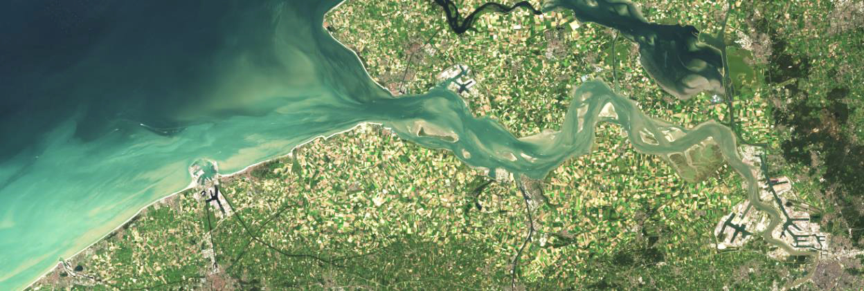
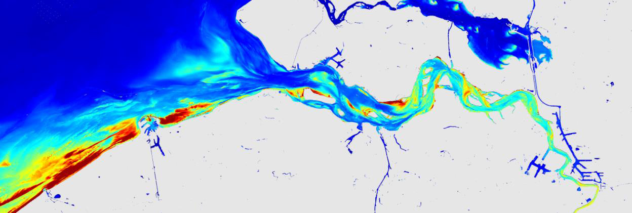
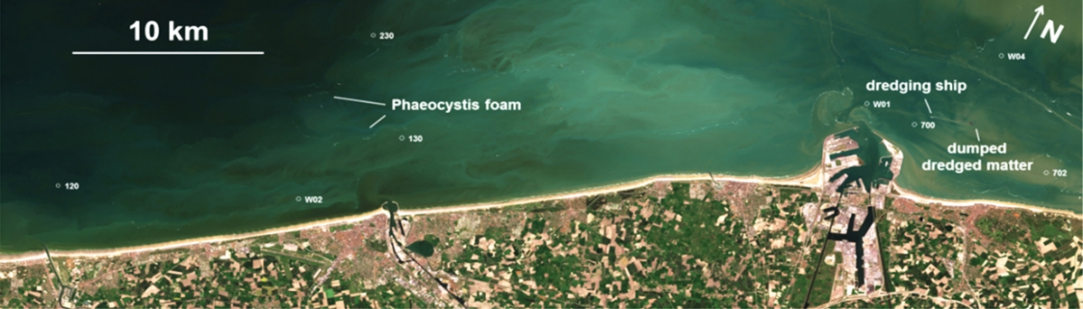
 Sentinel-2 image in true colours of the study area (10 m resolution) and Suspended Particulate Matter product (SPM)
To monitor the eutrophication status of the Belgian coastal zone and to detect potentially critical situations as quickly as possible, permanent operational surveillance is essential.
Traditional seaborne monitoring is still considered the main monitoring tool today. But this only provides point information and is very expensive.
Satellites to see better
Remote sensing offers solutions that have been explored by the MULTI-SYNC project (Multi-scale synergy products for advanced coastal water quality monitoring) led by the Royal Belgian Institute of Natural Sciences (RBINS) and financed by the STEREO programme of the Belgian Science Policy Office (BELSPO). The use of satellite images for monitoring combines many advantages. In addition to reduced cost, they provide information over the entire stretch of the Belgian territory of the North Sea and this with great temporal and spatial resolution. In addition, the image processing benefits from a technique called DINEOF that interpolates values in cloudy zones (regions where data of the ocean cannot be detected) developed by the ULg-GHER, partner of the project.
From scientific research to application
The degree of water eutrophication can be determined by their chlorophyll-a concentration, an indicator of phytoplankton biomass.
Using daily data from optical sensors specifically dedicated to ocean colouring (SeaWiFS, MODIS, MERIS, VIIRS, Sentinel-3), the researchers of the MULTI-SYNC project have developed an approach to map chlorophyll-a concentrations and other products like total suspended matter at high resolution.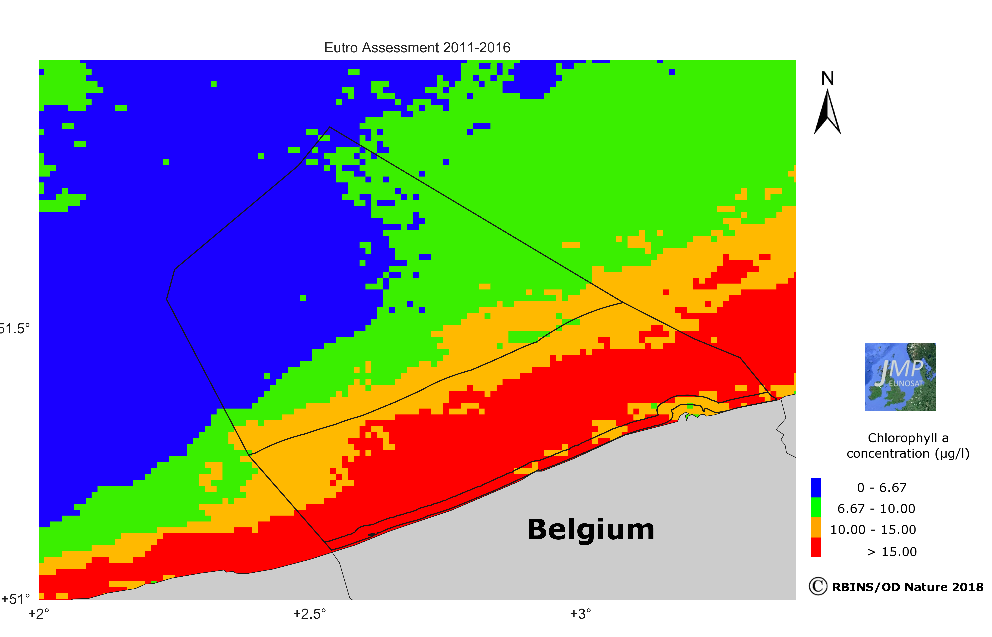 Eutrophication of the Belgian coastal zone. Regions with the highest concentrations (Chl P90 > 15µg L-1) are indicated in red. This map is made using MERIS satellite products with a spatial resolution of 1 km.
Thanks to these products, they can provide a spatial overview of the eutrophication status of the Belgian coastal area, where the problem areas are directly visible in red. These maps are integrated in the eutrophication assessment report provided by Belgium within the framework of European directives and therefore make it possible to directly support the actions necessary to achieve its objectives in terms of water quality.
 Sentinel-2 image of May 1st, 2016 (true colour image on top, and chlorophyll-a product below) showing a near-shore algal bloom near Ostend
In MULTI-SYNC, researchers aim to improve this service by developing new methods for using typical low-resolution ocean color data in synergy with high-resolution satellite data as provided by Sentinel-2. This type of satellite is able to provide chlorophyll-a products with a spatial resolution of up to 10 m, which allows the detection of near-shore algal blooms, undetectable by traditional ‘ocean color’ satellites or by in situ monitoring by boat.
Source text : Website Belgian Earth Observation