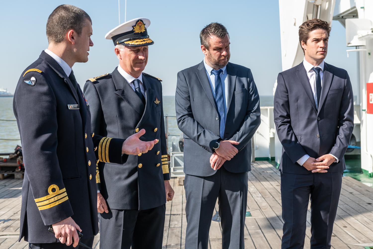
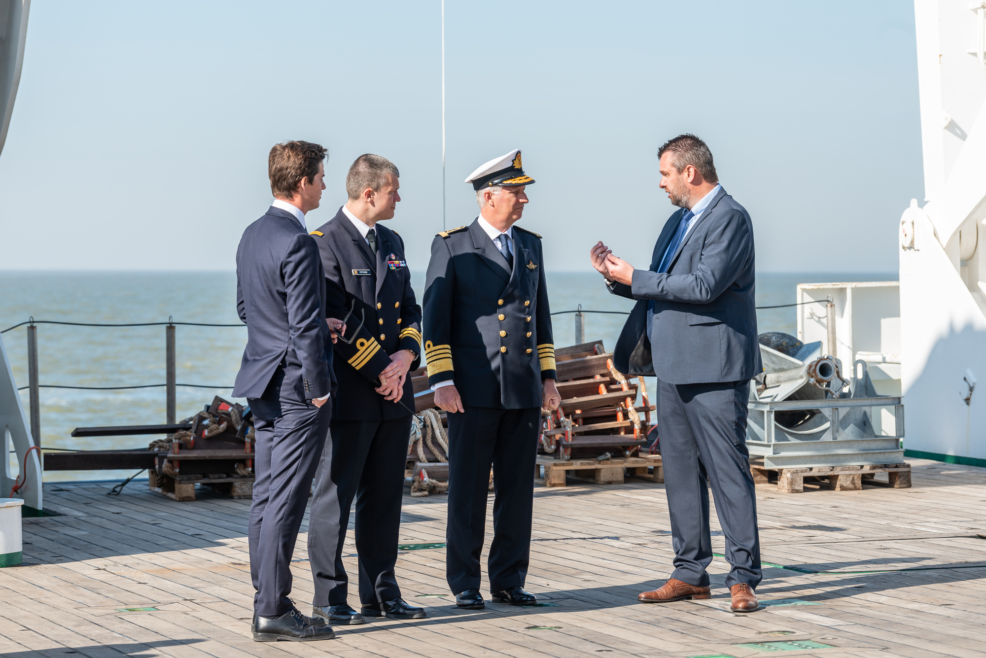
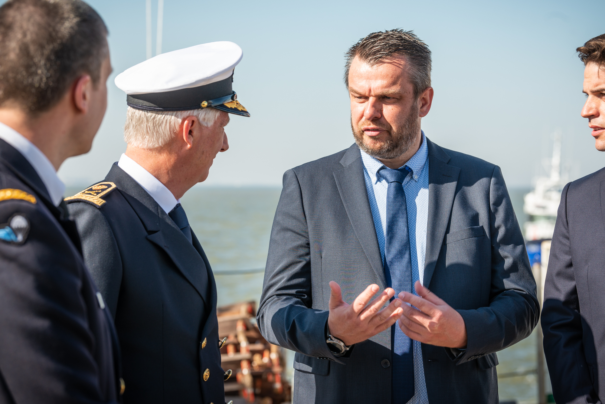
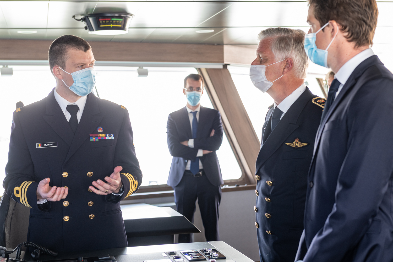
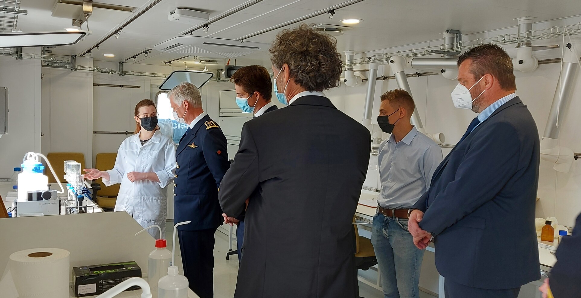
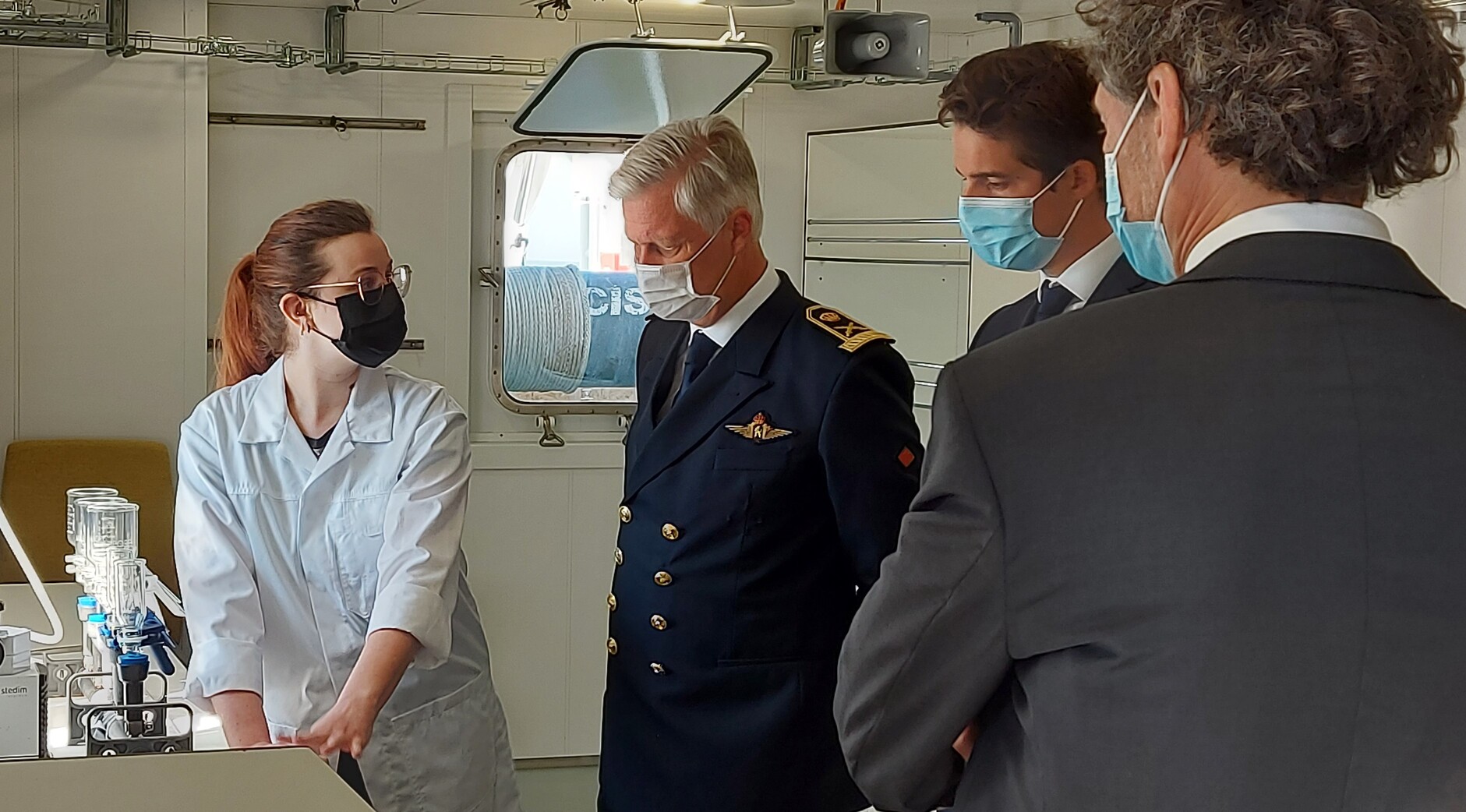
On Thursday 21 April 2022, His Majesty King Philippe visited the new research vessel RV Belgica. On this occasion, the Belgian Head of State and Commander-in-Chief of the Belgian Army (the naval component provides the bridge personnel and the homeport of Zeebrugge) was received and accompanied by Mr. Thomas Dermine, Secretary of State in charge of Science Policy, Mr. Arnaud Vajda, President of the Board of Directors of the Belgian Science Policy Office (BELSPO), Mrs. Patricia Supply, General Director a.i. of the Royal Belgian Institute of Natural Sciences (RBINS), Mr. Léandre Brehier, Administrative and Financial Director of Genavir, and of course by RV Belgica Captain Gaëtan Motmans and RBINS coordinator of the RV Belgica Mr. Lieven Naudts.
During a short trip at sea, the importance and functioning of the RV Belgica were extensively explained. This attracted great interest from King Philippe, which translated into many questions to those involved.
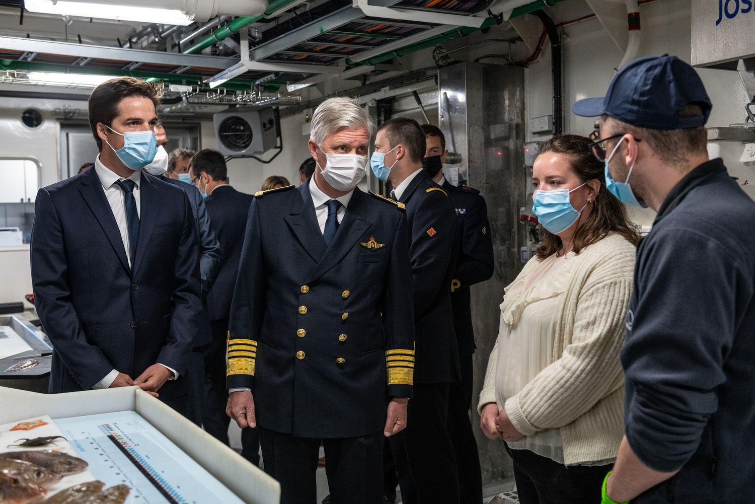
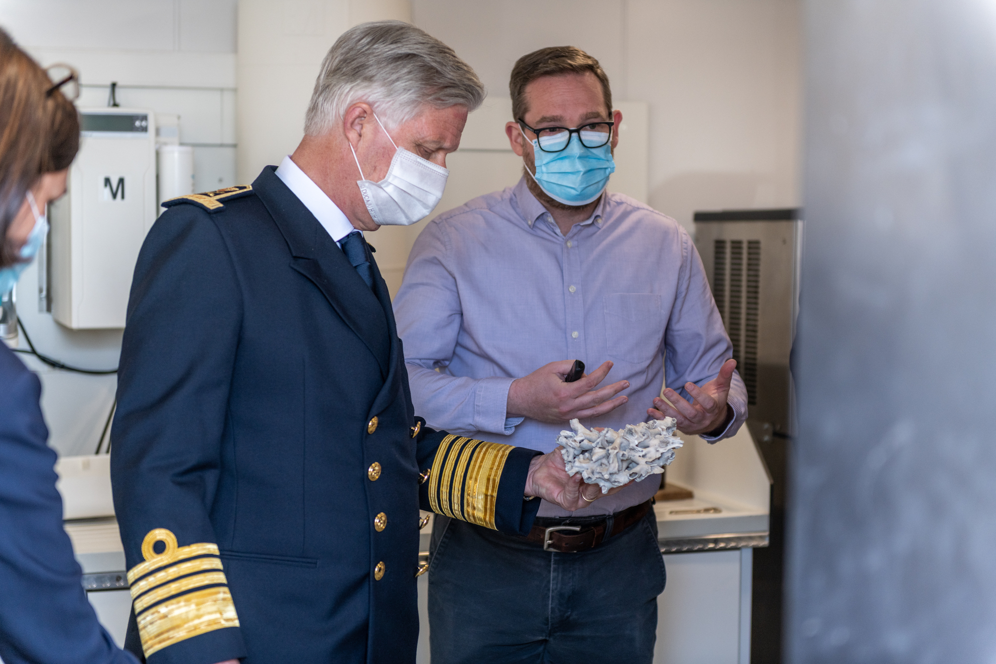
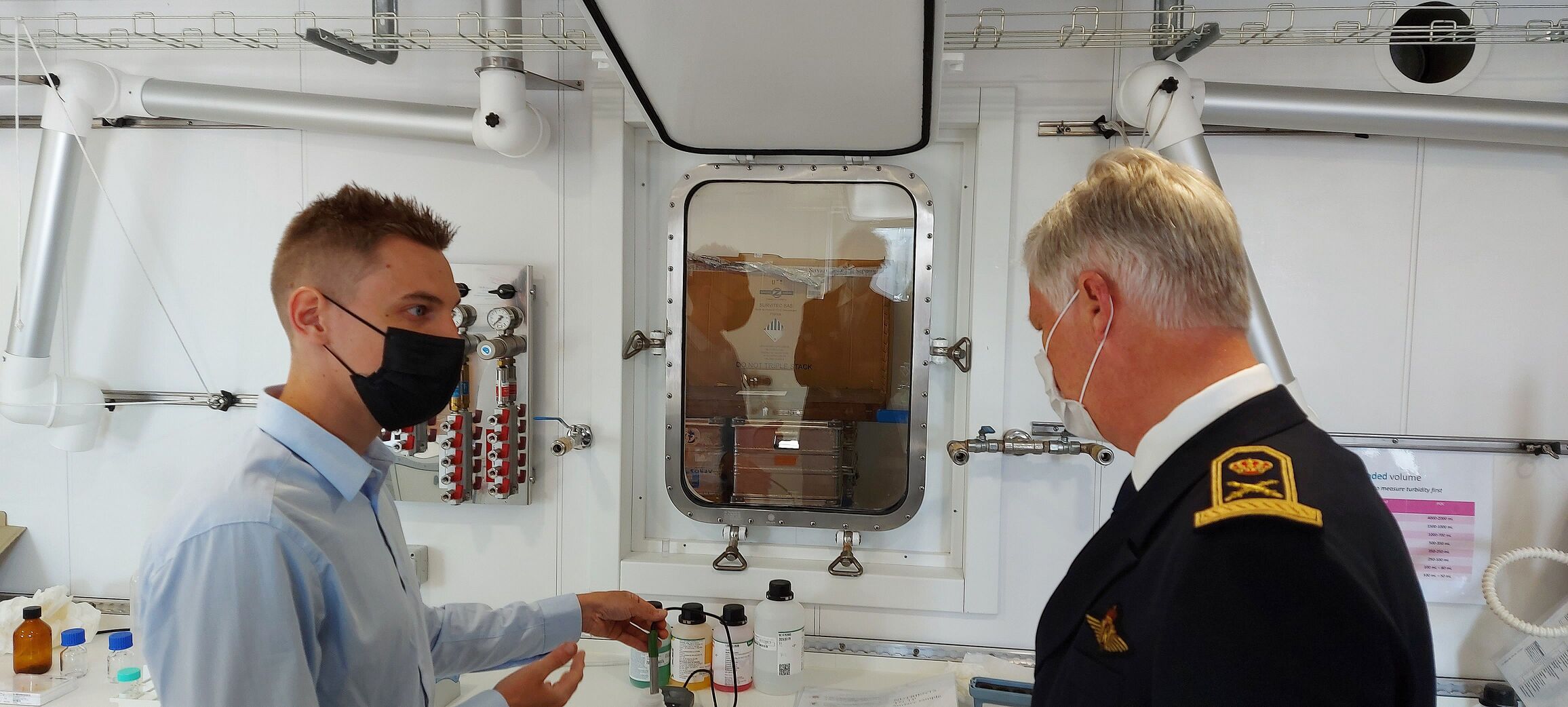
The programme started with an expert explanation of the ship and its scientific programme by Captain Gaëtan Motmans and Belgica coordinator Lieven Naudts. Their words formed the perfect stepping stone to some demonstrations of the various scientific activities that Belgian and international scientists can carry out thanks to the RV Belgica, and which put our country at the forefront of marine scientific research internationally. Attention was paid to biological, chemical, physical, geological and hydrodynamic research, and the demonstrations included both sampling (water and seabed samples) and laboratory activities (with thanks to the crew of the RV Belgica, and to Laura Lemey and Coenraad Deputter – ILVO, David Van Rooij – Ugent, and Kyra Gesquiere and Tom Scholdis – KBIN). Subsequently, King Philippe took the time for more extensive converstion with Belgica regulars. In addition to the persons mentioned above, 2nd Commander Anthony Willaert, Chief Engineer Antoine Samzun and Chief Electrician Andrejs Jankins of the RV Belgica were given the honour to talk with the King, as well as Mr Patrick Roose, Operational Director Natural Environment of the RBINS, Mrs Alice Matossian (Ugent), Mr Kris Hostens (ILVO) and Mr Michael Fettweis (RBINS).
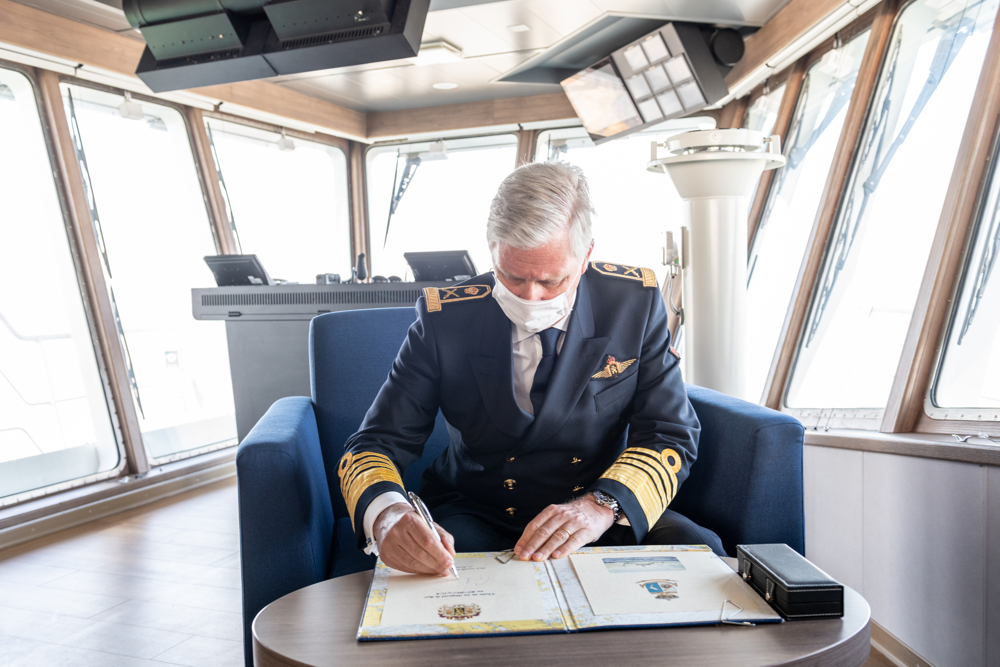
On the occasion of his visit, King Philippe also signed the Golden Book of the new RV Belgica.
After the event, the RV Belgica got ready for her first international campaign, the same afternoon she set sail for the Mediterranean Sea.
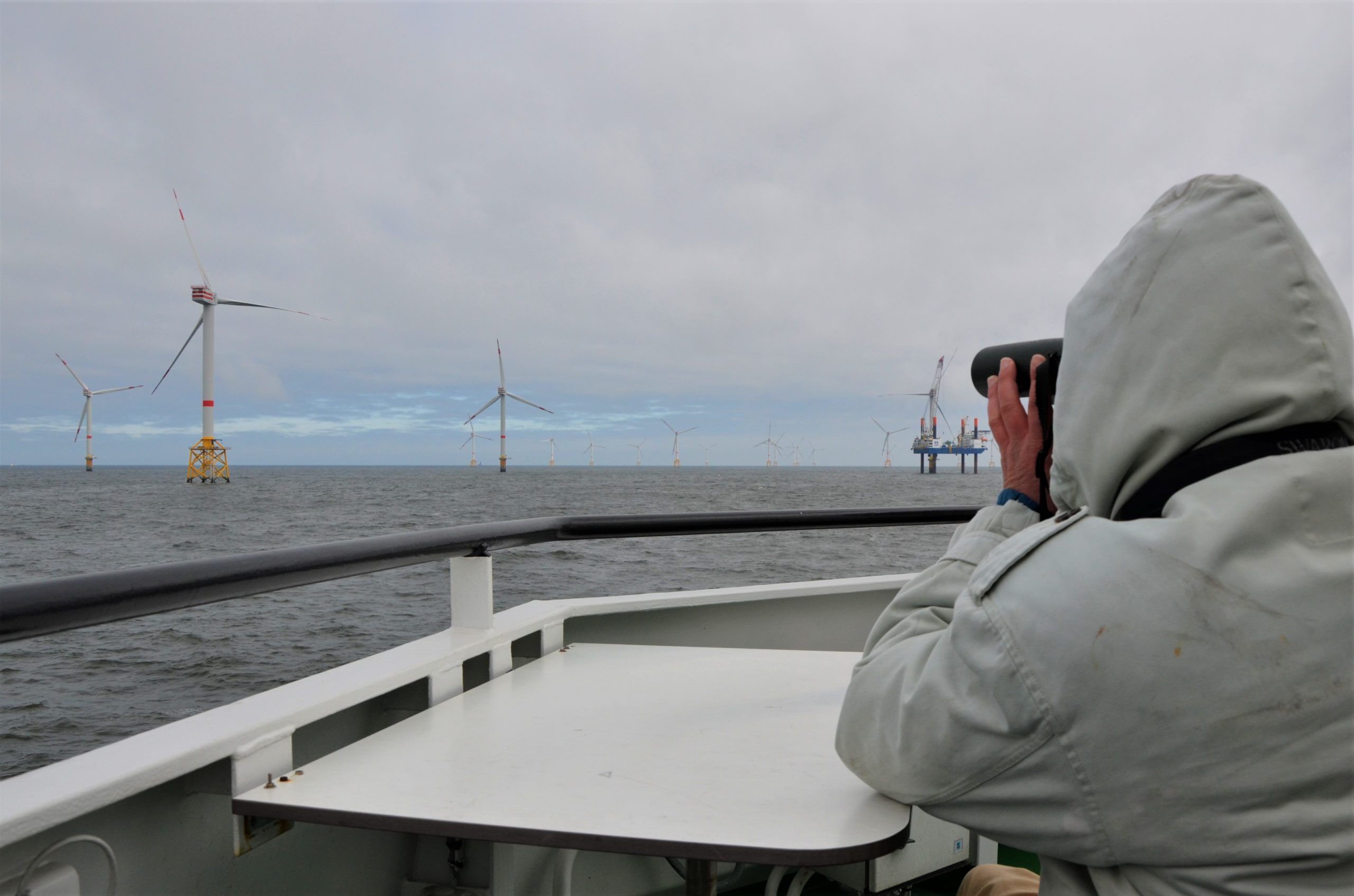
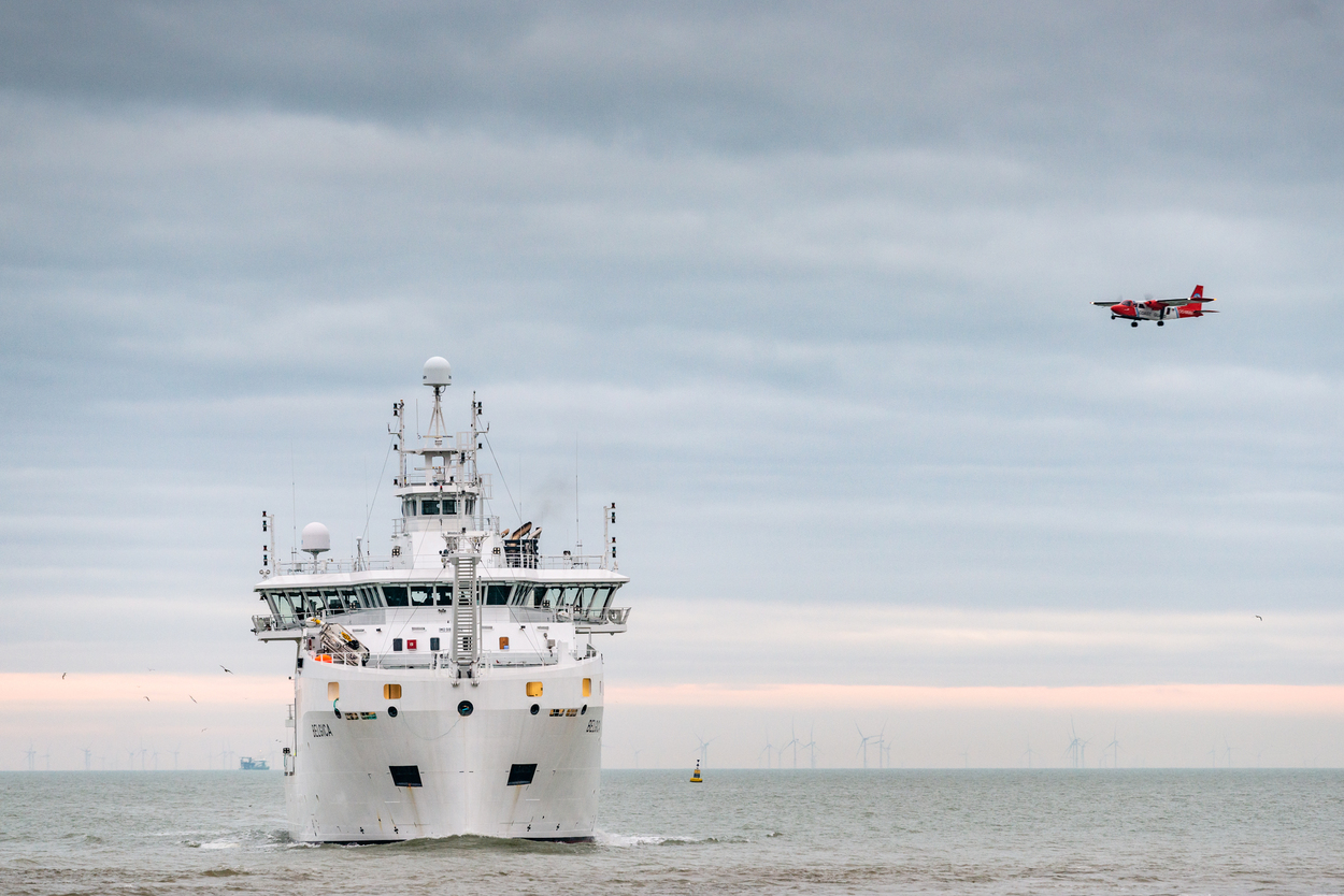
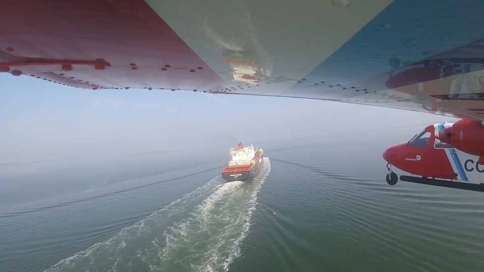
In 2021, the Royal Belgian Institute of Natural Sciences (RBINS) performed a total of 248 flight hours over the North Sea in the framework of the national programme of aerial surveys. Thirteen cases of operational discharges by ships have been observed. Additionally, suspected sulphur values have been measured in the smoke plumes of 16 vessels, while 23 vessels had suspected nitrogen values in their exhaust plumes. In 2021, a black carbon sensor was added to the sniffer setup to measure the amount of black carbon in ship emissions as well. With this capacity expansion, Belgium keeps on playing an international pioneering rolein the field of ship emission monitoring. Notwithstanding the COVID-19 pandemic, the aircraft also successfully participated in an internationally coordinated surveillance mission of the oil and gas installations in the central part of the North Sea and an international pollution control mission in the Skagerrak Strait. Two seasonal marine mammal counts were carried out successfully. Additionally, the aircraft executed 2 on call flights in response to emergencies at sea: a collision between 2 vessels without pollution and a small power boat with transmigrants drifting at the windmill parcs.
A total of 248 flight hours have been performed in the framework of the national North Sea aerial survey programme in 2021. This programme is organised by the Scientific Service MUMM (Management Unit of the Mathematical Model of the North Sea) of the Royal Belgian Institute of Natural Sciences, in collaboration with the Ministry of Defence. Due to the elaboration and application of an extensive Covid-19 switching plan, the initially foreseen target of flight hours was reached, despite the Covid-19 pandemic.
Most of the flight hours were for national flights (177 hours):
119 hours for pollution control: 54 hours for the detection of discharges of oil and other harmful substances (MARPOL Annex I, II and V) and 65 hours for the monitoring of sulphur and nitrogen emissions from ships (MARPOL Annex VI/ SO2 and NOx ECA – Emission Control Area enforcement, see further);
45 hours for fishery control, on behalf of and in cooperation with the Flemish Fishery Inspection Services;
2 “on call” hours in response to specific alerts: a collision without pollution and a search for a small power boat with transmigrants drifting in the wind farms.
2 hours in the framework of a pollution combating exercise.
9 hours for marine mammal monitoring.
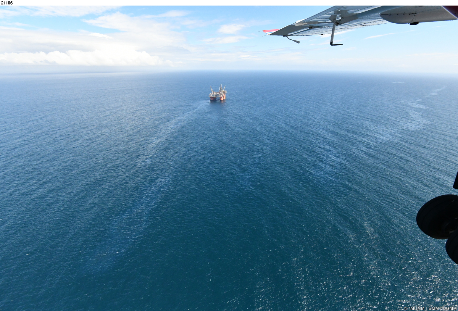
Additionally, 71 hours have been spent on international flights, of which 34 hours for the monitoring of sulphur and nitrogen emissions in Dutch waters on behalf of the Dutch Government (Human Environment and Transport Inspectorate) and, in the framework of the BONN Agreement, 19 hours for the Tour d’horizon-mission for aerial surveillance of offshore oil and gas installations in the North Sea and 18 hours for the Super-CEPCO mission, a mission to monitor discharges from ships in the Skagerrak Strait.
Operational discharges from ships
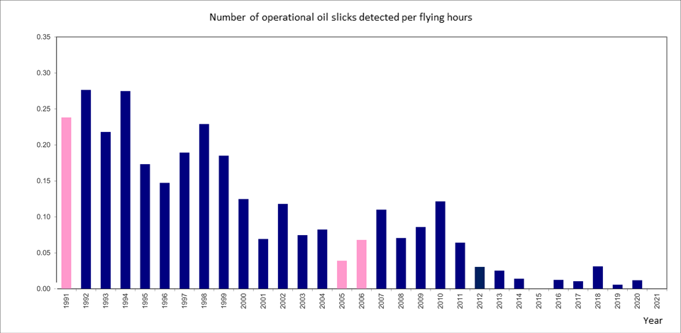
Since no accidental pollution took place in the Belgian sea areas in 2021, only operational ship discharges were observed. No operational oil pollutions were observed. These are deliberate discharges, which can be either legal or illegal, as stipulated in the various annexes to the MARPOL Convention.
None of these cases involved proven operational oil contamination. This is a confirmation of the decreasing trend in the figures showing that the number of oil pollutions has been greatly reduced in the last decade (see graph below).
Additionally, no violations with regard to Annex V of the MARPOL legislation related to the discharge of garbage and solid bulk materials were observed.
Thirteen cases of operational pollution from ships were observed:
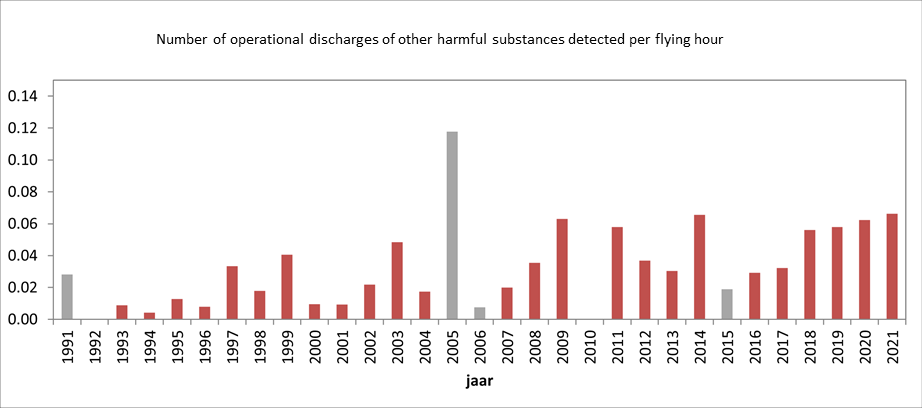
Eleven contaminations by hazardous liquids other than oil (MARPOL Annex II), one of which could be linked to a ship. An inspection was requested in the next port of call, which showed that it concerned an authorized discharge of FAME (fatty acid methyl ester). Three of these contaminants were verifications by the aircraft of a satellite detection alert. This Clean Sea Net (CSN) satellite surveillance service is offered by the European Maritime Safety Agency (EMSA) and regularly sends alerts from satellite detections of possible marine contaminants in the Belgian surveillance area.
2 pollution detections on radar of an unknown (not visually verified) liquid, at night time. Both detections were also a verification of a CSN satellite detection alert. Feedback was provided to EMSA for each verification.
Contamination by harmful liquid substances other than oil is still a common problem, which, as reported in previous years, even appears to be on the rise (see next graph). It should be noted here that this often concerns legal discharges that are in accordance with international discharge standards, as contained in Annex II of the MARPOL Convention. Since 2021, the MARPOL Annex II discharge standards have also been tightened for so-called ‘persistent floaters’ such as paraffin-like substances, for which no violations were observed.
Oil pollution in Belgian ports and the Western Scheldt
During the transit flights from Antwerp airport (the aircraft’s home base) to the North Sea, two oil slicks were observed in the port of Antwerp, which could not be linked to a ship. In the port of Ostend 2 oil slicks were observed as well but again it was not possible to identify the polluter from the aircraft with certainty. All findings were immediately reported to the competent authorities to ensure follow-up.
Monitoring of sulphur and nitrogen emissions from ships at sea
Due to application of a ‘sniffer’-sensor in the aircraft our country is known as a pioneer in the international combat against air pollution from ships at sea. The sensor makes it possible to measure multiple pollutants in the emissions of ships on site.
Sulphur measurements have been on the program since 2016. In order to monitor compliance with the stringent fuel sulphur content limits for ships sailing in the North Sea Emission Control Area, 57 sniffer fights (89 hours) were conducted in 2021, both above the Belgian surveillance area and the Dutch waters on behalf of the Dutch Government (Human Environment and Transport Inspectorate). Of the 1015 vessels of which the sulphur exhaust was measured at sea, 16 showed a suspiciously high sulphur value. These cases were systematically reported to the competent maritime inspection services for a further follow-up in port.
Due to the successful integration of a NOx sensor in 2020, the aircraft can also measure the concentration of nitrogen compounds (NOx) in the smoke plumes of ships to monitor and enforce the restrictions that apply in the North Sea from 1 January 2021 with regard to nitrogen emissions from ships. Belgium was the first country operationally ready to monitor and enforce these restrictions. In 2021 the nitrogen emissions of 1004 ships were inspected and 23 suspicious values were reported.
Since 2021, a new sensor has been added to the sniffer set-up: a black-carbon sensor. This sensor measures the amount of black carbon in the exhaust plumes of ships, which is a measure for the soot concentration. When exceptionally high soot concentrations are measured, the competent maritime port authorities are asked to take a fuel sample. These samples are analysed in the labs of MUMM in Ostend. With this black carbon sensor and oil sample analysis, new insights will be obtained about the role of the global shipping industry in the emissions of black carbon, which possibly might lead to international regulations to limit black carbon emissions in the future.
The annual TdH-mission for the surveillance of offshore platforms in the central part of the North Sea (in Dutch, German, Danish, Norwegian and British waters), performed in the framework of the Bonn Agreement, was conducted in July 2021. The Belgian surveillance aircraft detected 20 pollutions, of which 18 consisted of oil and 2 of an unknown liquid substance which could not be visually verified due to low clouds.
Nineteen spills could be directly linked to offshore installations. One oil spill could not be linked to a platform or ship. All detections were systematically reported for further follow-up to the competent Coastal State, in accordance with agreed international procedures.
In 2021 the Belgian Coastguard aircraft also participated in an international Super-CEPCO (Coordinated Extended Pollution Control Operations) mission. During such a mission, surveillance aircrafts from different North Sea countries jointly carry out continuous surveillance over a certain (high-traffic) zone for several days. During the 2021 mission, hosted by Norway, planes from 6 North Sea countries gathered in Oslo to perform pollution control flights over the Skagerrak Strait for 3 days. On the flight to Oslo, the Belgian Coast Guard aircraft observed 1 operational MARPOL Annex II discharge in German waters and 1 small oil spill without polluter in the Oslofjord.
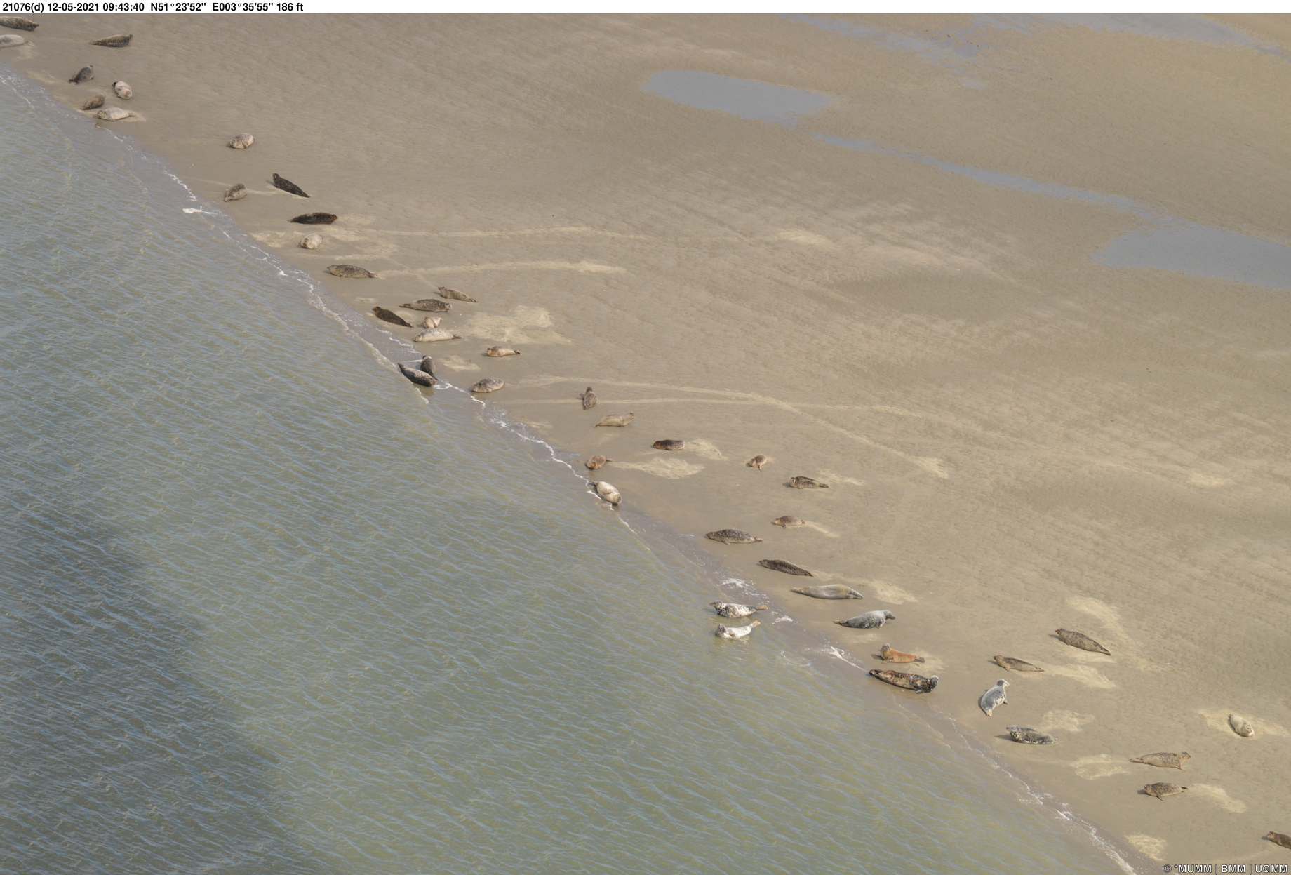
Monitoring of Marine Mammals
In 2021, RBINS conducted two surveys in Belgian waters to determine the distribution and density of harbour porpoises. Such surveys are also carried out in other North Sea countries in a standardized manner, in order to obtain long-term data that yield a bigger picture of the seasonal population dynamics of harbour porpoises (Phocoena phocoena) and other marine mammals in the North Sea.
As in 2020, the surveys in 2021 were conducted in June and September. An equal number of harbour porpoises were observed during both surveys: 52, including 4 and 9 calves respectively. The average estimated density in Belgian waters was higher during both surveys than in 2020: an average of 0.81 (0.52-1.28) and 0.78 (0.44-1.35) respectively for harbour porpoises per km² sea area, or in a total an estimation of 2700 animals.
Maybe more striking than the number of harbour porpoises was the number of seals: in June there were nine animals, including (based on size) at least one grey seal. In September, 20 seals were seen, of which (at least) seven were identified as grey seals, the highest number of seals ever recorded during an aerial survey.
Emergency interventions: collision at sea and transmigration issues
On 13 March 2021, there was a minor collision between two ships in the Westhinder anchorage area. The ships involved were the XING ZHI HAI (bulk carrier) and the ASTREA (tanker). The later was at anchor. The Coast Guard aircraft was activated that day and confirmed that there was only minor damage to both ships and that there was no contamination.
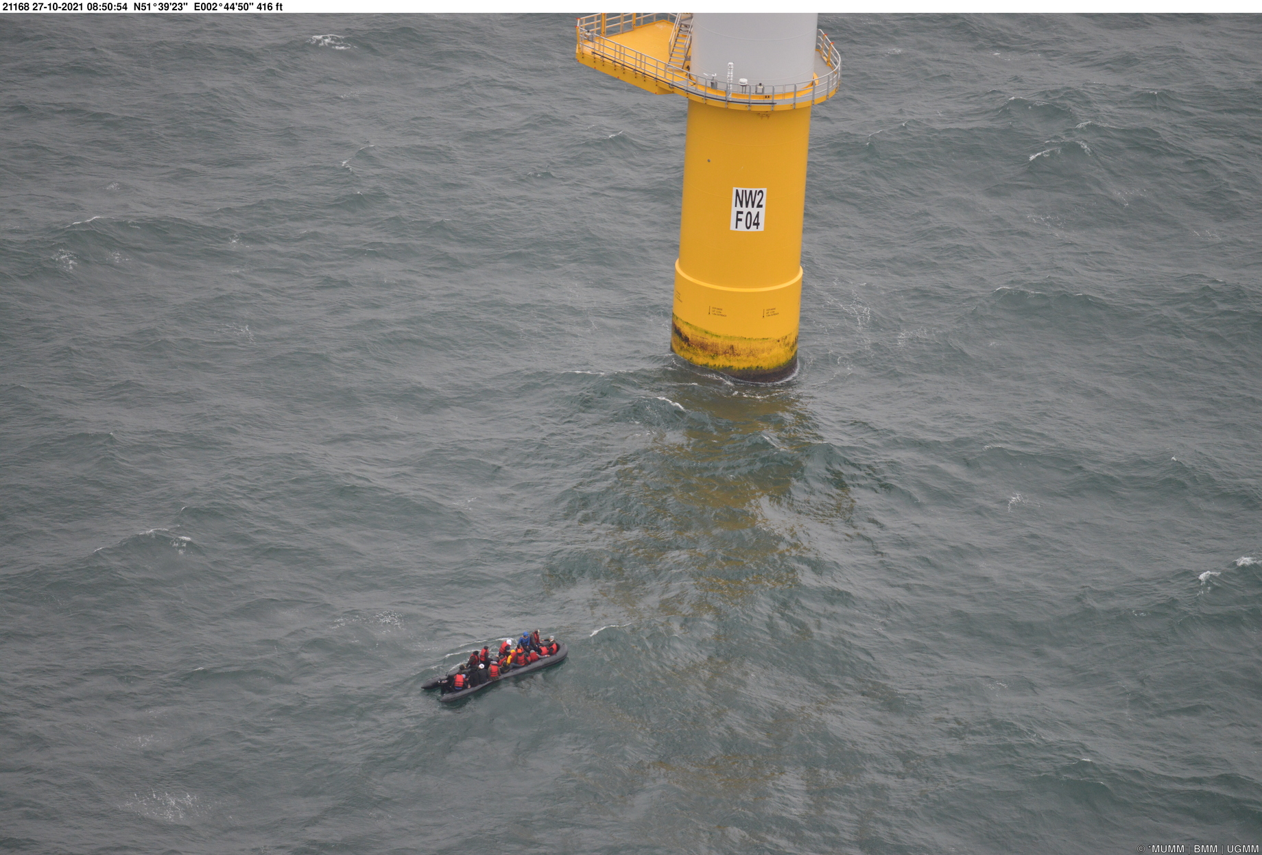
The aircraft also regularly flies in support of the Coast Guard, also in areas for which the MUMM is not specifically authorized or the aircraft is not specifically equipped for. For example, the crew regularly documents various observations (other than environmental) that are systematically reported to the Coast Guard centers and authorized partner organisations. The surveillance aircraft was unfortunately confronted several times in 2021 with the increased transmigration problem in and around our waters.
On 27 October 2021, while the aircraft was in operations on the coast, it was called by Coast Guard Central Services to report that a small boat carrying transmigrants was in distress near the wind farms. The aircraft was able to take off quickly and was the first coastguard platform on site. It was able to inform the competent authorities about the situation.
It concerned a rubber boat with 24 people on board that was adrift towards the wind farms. The rescue helicopters from Koksijde and a Navy vessel then arrived on the scene and managed to bring all those on board to safety. Throughout the year, other observations linked to transmigration also took place, but without people on board, these usually concerned abandoned boats or life jackets.
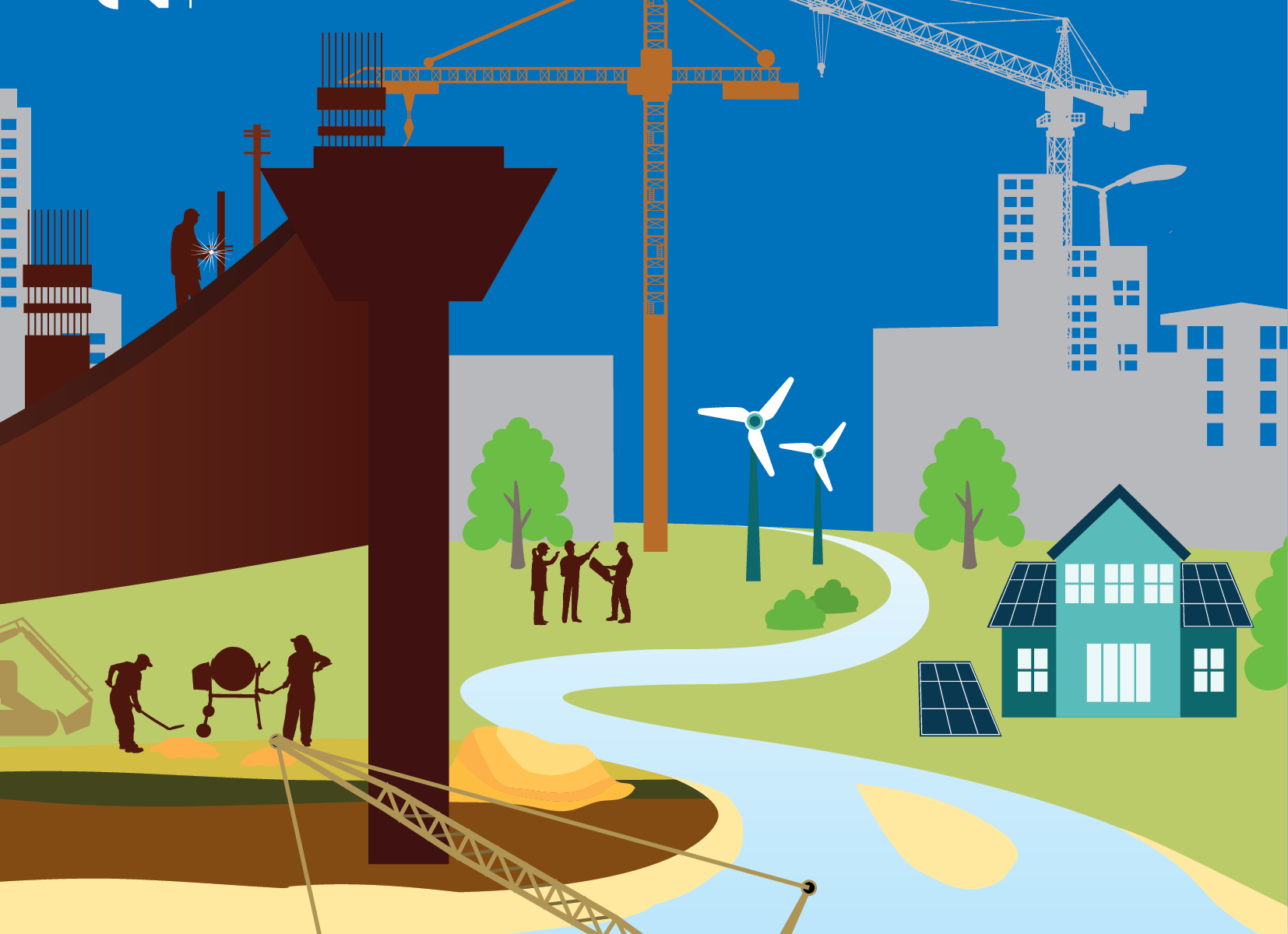
Sand is vital for building the foundations of our society. Currently, around 50 billion tonnes of this raw material are extracted worldwide each year, and the growing world population is only increasing demand. The environmental and social impacts are forcing us to rethink our dealings with sand. In a new report launched today by the United Nations Environment Programme (UNEP), experts from around the world make recommendations to switch to better practices for the extraction and management of sand. Experts from Belgium were also involved. New developments in Belgian policy proactively anticipate an increasing demand for marine sand.
50 billion tonnes, this is the amount of sand (and gravel) that we as a world population consume every year, making it the second most used resource in the world after water. Enough to build a wall 27 metres wide and 27 metres high around planet Earth. Despite the strategic importance of sand, its extraction, use and management are largely unregulated in many parts of the world, with numerous environmental and social consequences that are largely overlooked. Where sand plays an active role in the ecosystem, such as in rivers, coasts and shallow seas, extraction can lead to erosion, salinisation of aquifers, loss of storm protection and impacts on biodiversity, which in turn threaten our water supply, food production, fisheries or the tourism industry, among others.
Increasing demand
Sand is vital for building the foundations of our society: our houses, roads, bridges, hospitals, schools, dams, but also, for example, photovoltaic panels to produce renewable energy, … these are just some of the many applications of sand that we have developed. Sand can justifiably be called the unrecognised hero of our development.
We have become accustomed to easily accessible sand supplies, with the result that sand is often used faster than it can be replenished by natural geological processes. As the world population is growing rapidly, and the proportion of the urban population is expected to increase to over 68% by 2050, the demand for sand will only increase.
10 recommendations to avert a crisis
It is therefore high time to reassess our dealings with sand, and to recognise sand as a strategic resource. This is stated in the new report Sand and Sustainability: 10 strategic recommendations to avert a crisis‘ launched today by the United Nations Environment Programme (UNEP). In this report, experts from around the world and from various sectors bring together recommendations to move towards better practices for the extraction and management of sand.
The recommendations include establishing integrated policy and legislative frameworks, mapping sand resources, promoting resource efficiency and circularity, responsible procurement and restoring degraded ecosystems. The major objective of this report is to encourage policy makers at all levels of government to adopt relevant policies and standards and promote best practices in line with local sand dependencies and development needs.
The 10 recommendations
Recognise sand as a strategic resource that provides critical ecosystem services and is the basis for building vital infrastructure in developing cities around the world.
Consult with all stakeholders (involved and impacted) on decision-making and implementation of sand extraction.
Enable the transition to a regenerative and circular economy.
Implement strategic and integrated policy and legislative frameworks, in line with local, national and regional realities.
Property rights and regulated access to sand resources through mineral rights and permits contribute to sustainable sand mining.
Map, monitor, and report on sand resources for transparent, science-based and data-driven decision-making.
Promote the development of best practice guidelines and national standards, as well as a coherent international framework.
Reduce the use of sand and replace it with alternatives and recycled sand products where possible.
Buy sand in an ethical, sustainable and socially conscious way.
Restore ecosystems and compensate for losses by increasing the knowledge base, integrating mitigation measures in mining operations, and promoting nature-based solutions.
Pro-active management of marine sand resources in Belgium
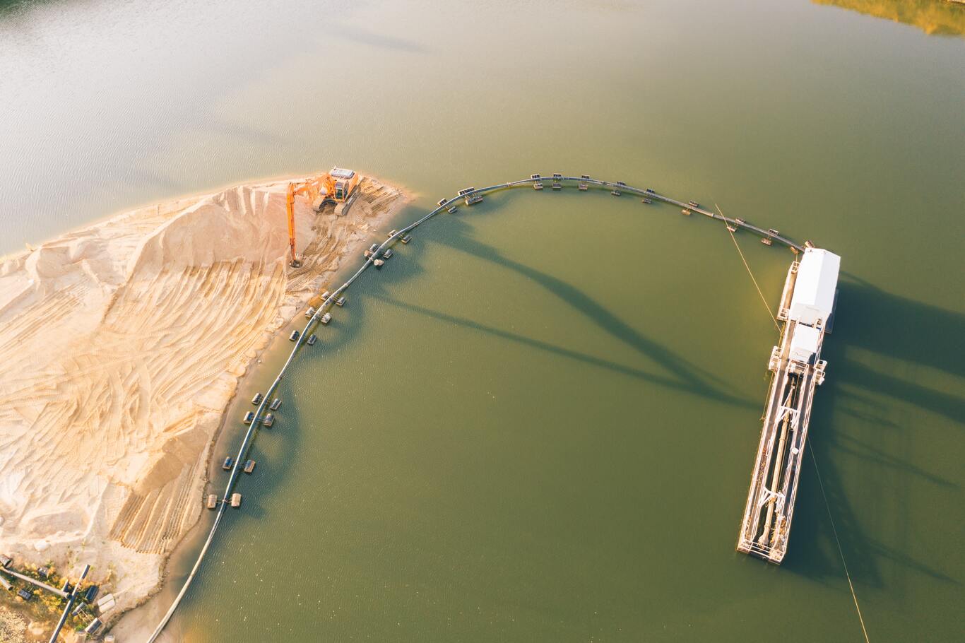
The demand for sand, and in particular marine sand, is steadily increasing in Belgium. The Continental Shelf Service of the Federal Public Service Economy manages Belgium’s sea sand resources and does so in a proactive manner, relying on the best available knowledge and monitoring methodology. Building on research results, an innovative policy is in force that imposes a lower limit on extraction based on the geological reserve, as well as criteria to minimise the impact on the seabed environment. This new benchmark has been in place since 2020, is being closely monitored, and represents a real paradigm shift in favour of sustainable management of the resource.
An evaluation of the marine sand exploitation in the Belgian part of the North Sea leads to the conclusion that the management of our marine sand stock is already in line with recommendations 1, 4, 5, 6, 7 and 9 of the new UNEP report. Recommendations 2, 3 and 8, which focus on the transition to a circular sand economy, are obviously also very important to implement, and fit into a larger transition framework which in the meantime should not prevent us from continuing the current marine sand exploitation within the established sustainable environmental and socio-economic boundaries. Based on the monitoring results (bathygeomorphology, sediment and benthic biota) obtained before, during and after the sand extraction in various Belgian sand extraction zones, recommendation 10 on ecosystem restoration is not critical for the Belgian part of the North Sea.
Belgian contribution to the UNEP report
Vera Van Lancker of the Royal Belgian Institute of Natural Sciences and professor at Ghent University was responsible for the recommendation on sand mapping and use, environmental monitoring and reporting with emphasis on the need for decision support systems (Recommendation 6). Globally, but also regionally, the quality and quantity of available sand is hardly known. However, the demand for sand is unprecedentedly high and increasing, with large-scale mining possibly becoming the new norm. However, the knowledge base to support such extraction is minimal. The joint consideration of geological, environmental and socio-economic parameters is therefore of paramount importance for informed decisions. With increasing extraction, and possible scarcity, the dependencies between man and nature, but also between sandy and poor regions, are put to the test. For a more systematic understanding of these dependencies, and to support (cross-border) decision-making, the need for data, knowledge and information, as well as predictive science, is greater than ever.
Vera: “The challenges of increasing sand use are great, whereby contemporary practices and associated impacts may not be appropriate. An accelerated mapping of sand resources is needed for which structural cooperation offers the most perspective. This requires more standardisation in the classification of raw materials, which also takes into account the environmental and socio-economic dimension. Predictive modelling of extraction scenarios and man-nature dependencies is becoming more important.”
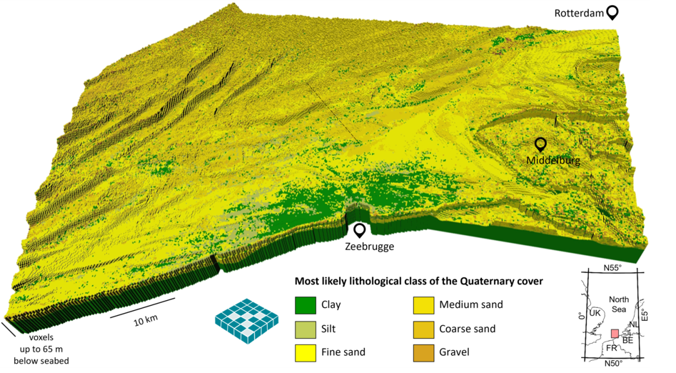
Transnational subsurface resource model of the Quaternary sediments of the territorial sea and exclusive economic zone of Belgium and the Netherlands (south of Rotterdam). (Source: Van Lancker et al. 2019 p.32)
Aurora Torres, Marie Skłodowska-Curie Postdoctoral Fellow at the Université Catholique de Louvain, led the recommendation on restoring degraded ecosystems (Recommendation 10), together with other experts. Sand is fundamental to maintaining biodiversity and the variety of ecosystem services that meet societal needs. Policy makers, industry and other stakeholders are therefore encouraged to take measures to avoid and minimise risks to biodiversity and ecosystem services, restore ecosystems and compensate for remaining losses. Also in the perspective of the UN targets for ecosystem restoration (2021-2030), further efforts are needed to better document the impacts of mining on biodiversity and ecosystem services, to improve the effectiveness of mitigation and restoration efforts, and to ensure the use of science-based assessment and monitoring as a basis for impact assessment, mitigation planning and compensation. Finally, sand also contributes to the restoration and protection of land, freshwater systems or coastal areas against erosion or flooding. Nature-based solutions and ‘building with nature’ approaches are strongly recommended here.
Aurora: ” Transitioning to a circular economy requires that we become less dependent on natural systems as material suppliers. When extraction is deemed necessary, sand resources must be obtained in a responsible manner that prevents or minimises damage to ecosystems and people.”
Astrid Smeets and colleagues of Bureau Brussels contributed to recommendations on how to include sustainability in the entire supply chain from the origin of sand to its user, and how to achieve a broader societal change (Recommendations 3 and 9). These range from (re)educating architects to use alternative materials, to a fiscal policy directing financial flows towards alternatives to sand or more sustainable extraction and use. In order to create a stimulating policy, it is important that governments and companies come together to share and apply best practices. By tackling a more sustainable sand policy at an international level, one can learn from local solutions that already exist and which, with minor adjustments, can easily be applied on the other side of the world. This is both time and cost efficient.
Astrid: “The transition to a more sustainable raw materials policy will also be felt here in Belgium. We see Europe tackling the sustainability of supply chains at an unseen pace with, among others, the EU Taxonomy and supply chain liability. Companies and governments will have to account for the impact of their activities on people and the environment. In addition, they will have to demonstrate how sustainable they and their suppliers are. Sand will undoubtedly also be on the agenda in the near future. With the ten recommendations from the report, governments, knowledge institutions, the business community and consumers can get started to avert a major crisis. The sooner we start looking for solutions, the better for people, planet and our economy.”
ANNEX 1: More information on marine sand extraction in Belgium
Numbers and more information on the management of marine sand resources in the Belgian part of the North Sea, the scientific basis, and the ecological impact:
Continental Shelf Service: General – Study Day 19 Nov 2021 – A 360° perspective on Sea Sand (French – Dutch)
The FPS Economy, SMEs, Self-employed and Energy, Continental Shelf Service, is the competent government agency for sand extraction at sea. Together with the Royal Belgian Institute for Natural Sciences (RBINS) and the Flanders Research Institute for Agriculture, Fisheries and Food (ILVO), the physical and biological changes in sand extraction areas are monitored, and recommendations are formulated to minimise the impact. During three-yearly study days, the results are presented in an integrated way, and attention is also paid to the broader sustainability framework.
Royal Belgian Institute for Natural Sciences (RBINS). Federal Scientific Institute that combines fundamental and applied research, among others for estimating the effects of human activities in marine waters. With regard to sand extraction, efforts are being made to better understand the variability of sediment characteristics and processes, to model the activity-pressure chain effects on the marine environment, and to formulate recommendations for a more sustainable use of marine resources. To this end, the RBINS coordinated the Belspo TILES project that mapped the quality and quantity of sand stocks. Further valorisation and new initiatives are being developed within the framework of the European ‘Geological Service of Europe’ action, in which the European Geological Services are joining forces in support of societal challenges.
Université Catholique de Louvain, Earth and Life Institute, has as a major goal the design of sustainable solutions to some of the biggest challenges facing our societies (e.g. transitions to sustainable land use, the influence of globalisation on decisions, and the interactions between public and private governance). UCLouvain is collaborating with Michigan State University to investigate important links between sand use, economic activity, environmental pressures and social impacts (SANDLINKS: https://cordis.europa.eu/project/id/846474).
Bureau Brussels is a public affairs consultancy supporting businesses, public authorities and non-profit organisations in the European policy-making process. Bureau Brussels supports for clients in various fields such as women’s health care, circular economy, sustainability, digital and financial sectors. From a circular point of view and a chain approach, the topic of ‘sand’ has also been on the agenda for a number of years.
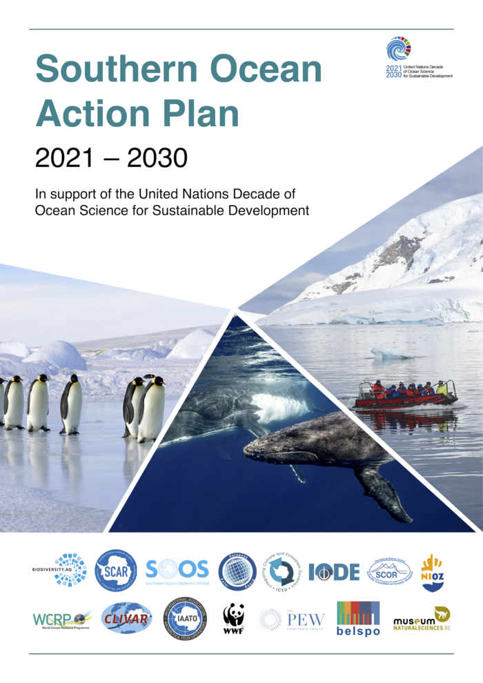
In the Southern Ocean, human presence and the combined effects of various forms of pollution, transport, infrastructure, and the pursuit of living resources, together with accelerated climate change, are exerting increasing pressures on the environment. These changes have the potential to alter the role of the Southern Ocean in regulating global climate and other systems, which will in turn impact a host of other important ecosystem services. Being well adapted to stable environmental conditions, with unique traits, Antarctic species are considered more vulnerable to environmental perturbations and pollutants, compared to species from more northerly latitudes. The vast, remote and harsh environment of the polar regions means that no single nation can develop and implement a research and data strategy to understand and manage these regions.
The UN Ocean Decade and the Southern Ocean Community
In 2017, the United Nations proclaimed a Decade of Ocean Science for Sustainable Development (hereafter referred to as the UN Ocean Decade) from 2021 until 2030 to support efforts to reverse the cycle of decline in ocean health. To achieve this ambitious goal, this initiative aims to gather ocean stakeholders worldwide behind a common framework that will ensure ocean science can fully support countries in creating improved conditions for sustainable development of the world’s oceans. The initiative strives to strengthen the international cooperation needed to develop the scientific research and innovative technologies that can connect ocean science with the needs of society at the global scale.
The UN Ocean Decade Societal Outcomes align strongly with the remit of the Antarctic Treaty (see below). The Southern Ocean community, that involves not only the scientific research community but a much broader group with representatives of the business and industry sector as well as governance and management bodies, therefore recognises the need to develop and implement a coordinated, international plan that builds on our existing understanding of how human interaction with the Southern Ocean can benefit people and societies in ways that will also contribute to the protection and conservation of the unique characteristics of these regions.
Uplifting Southern Ocean Actions to Global Standards
The Southern Ocean is underrepresented at the international level, despite playing an important role in regulating climate and many other systems at the global scale. The Southern Ocean Task Force will benefit from the UN Ocean Decade in order to provide a platform to underline the importance of the Southern Ocean and highlight its relevance in the Earth System. Owing to its well-established operation, the Southern Ocean community is uniquely placed to join the United Nations Decade of Ocean Sciences for Sustainable Development.
Based on the recommendations in the Implementation Plan of the UN Ocean Decade, the Southern Ocean community engaged in a stakeholder-oriented process to develop the Southern Ocean Action Plan. As part of this global effort, the Southern Ocean Task Force identified the needs of the Southern Ocean community to address the challenges related to the unique environmental characteristics and governance structure of the Southern Ocean. Through this community-driven process, synergies within the Southern Ocean community and beyond were identified in order to elaborate an Action Plan that provides a framework for Southern Ocean stakeholders to formulate and develop tangible actions and deliverables that support the UN Ocean Decade vision.
The Southern Ocean Action Plan
With funding obtained via the Belgian Science Policy Office (BELSPO), the Royal Belgian Institute of Natural Sciences (RBINS) took on a leading role in coordinating the Southern Ocean Task Force and guiding the Southern Ocean process.
The Southern Ocean Decade and Polar Data Forum Week 2021, co-organised in September 2021 by RBINS and the European Polar Board, was one of many concrete initiatives. The week-long event gathered 400+ participants with diverse backgrounds, which allowed for cross-fertilisation of ideas between researchers, data managers, policymakers, business, industry representatives, etc. The discussions and collaborative work culminated in the publication of the Southern Ocean Action Plan, that was publicly launched during a webinar on April 12th, 2022.
The Action Plan describes the bridges we need to achieve the Southern Ocean we want, with respect to
Funding: Securing sufficient and long-term funding, and coordination of the funding, is particularly crucial for the Southern Ocean, as many areas are inaccessible throughout the winter season. Therefore, there is a need to coordinate calls to improve the technological capabilities to operate in and observe inaccessible areas year-round, to transport, maintain and rapidly analyse samples, and to support the establishment of a sustained collaborative network of long-term observatories.
Crossing boundaries: Transcending national efforts internationally, linking research disciplines, and co-designing global polar research priorities, are crucial for a long-term and integrative research strategy.
Identifying and connecting stakeholders: Improving the dialogue at the science-policy interface, ensuring that societal needs are reflected and addressed through research, and linking the industry with research, infrastructure and logistics, will illustrate the potential of available knowledge and the uptake by stakeholders (including decision-making) and lead to better management practices and strengthened protection of the fragile Southern Ocean region.
Data, observations and modelling: Informed decision making to achieve the ocean that we want relies upon appropriate scientific input, which itself relies upon scientific data. In order to make the best possible use of such data, we must improve spatial and temporal coverage, ensure that data are fully utilized, maintain data series and continually make these available to new generations of researchers, and make maximal use of modelling and new and novel techniques (such as Artificial Intelligence and Machine Learning Techniques).
Capacity building, inclusion and diversity: The current capacity of the Southern Ocean community is not sufficient to address all of the issues that are now being faced, many of which have important societal implications. Therefore, there is a need to ensure diversity of voices at the table (at all stages of planning, research, funding and data sharing), to invest in capacity building, and improve technology for better access to data and information.
“Through the publication of the Southern Ocean Action Plan, the Southern Ocean Task Force aims to mobilise the Southern Ocean community and inspire all stakeholders to seek engagement and leverage opportunities to deliver innovative solutions that maintain and foster the unique conditions of the Southern Ocean” says Annemie Rose Janssen of the RBINS, and lead author of the Action Plan. “This framework provides an initial roadmap to strengthen links between science, industry and policy, as well as to encourage internationally collaborative activities in order to address existing gaps in our knowledge and data coverage.”
As such, and being part of the UN Ocean Decade, the Southern Ocean Action Plan aims to contribute to the achievement of the UN Agenda 2030 and its Sustainable Development Goals in a polar context. Only in this way can we achieve a clean, healthy & resilient, productive, predicted, safe, transparent & accessible, and inspiring & engaging Southern Ocean.
We thank the Belgian Science Policy Office (BELSPO) for the financial support under BELSPO contract n°FR/36/ AN1/AntaBIS and BL/36/FWI34_PUNDOS-PPODS in the Framework of EU-Lifewatch.
The Antarctic Treaty was signed in 1959 by the 12 countries whose scientists had been active around Antarctica in 1957-58, including Belgium (there are 54 members nowadays). It entered into force in 1961 and describes, among other things, the intentions to only use Antarctica for peaceful purposes, to guarantee the freedom of scientific investigation in Antarctica, and to make scientific observations and results from Antarctica freely available.
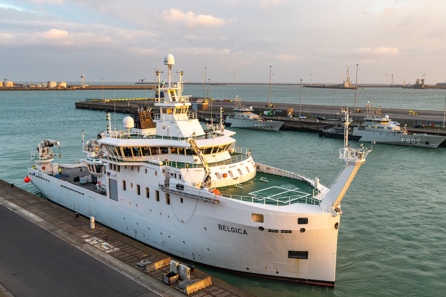
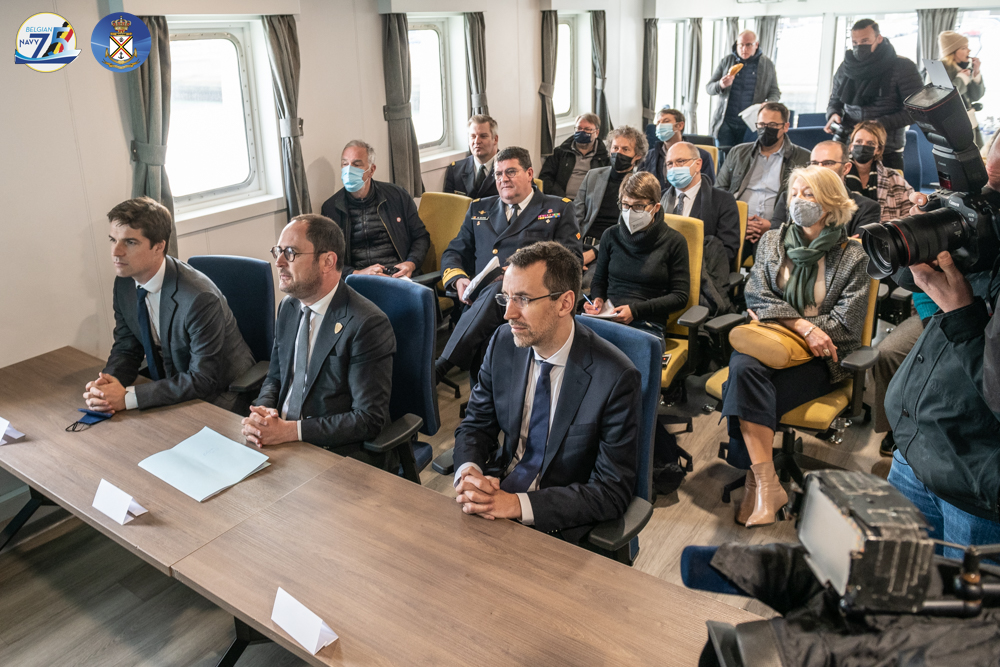
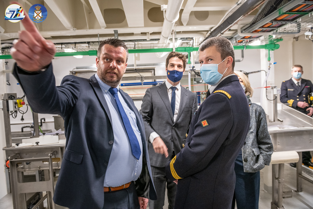
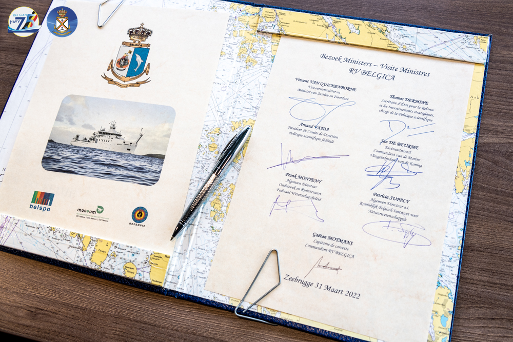
On Thursday 31 March 2022, the Deputy Prime Minister and Minister for Justice and the North Sea, Mr Vincent Van Quickenborne, and the State Secretary for Relance and Strategic Investments, in charge of Science Policy, Mr Thomas Dermine, visited the new Belgian research vessel ‘RV Belgica’ (‘RV’ stands for ‘Research Vessel’). The presence of the Minister of Defence, Mrs Ludivine Dedonder, was also foreseen, but unfortunately she had to excuse herself. During the visit, the emphasis was on the unique cooperation between the three policy areas with regard to the management, operation and deployment of the vessel. Special attention was also paid to the new scientific challenges that Belgian and international marine scientists will face thanks to the new RV Belgica. The visit took place at the naval base of Zeebrugge, the home port of the new RV Belgica.
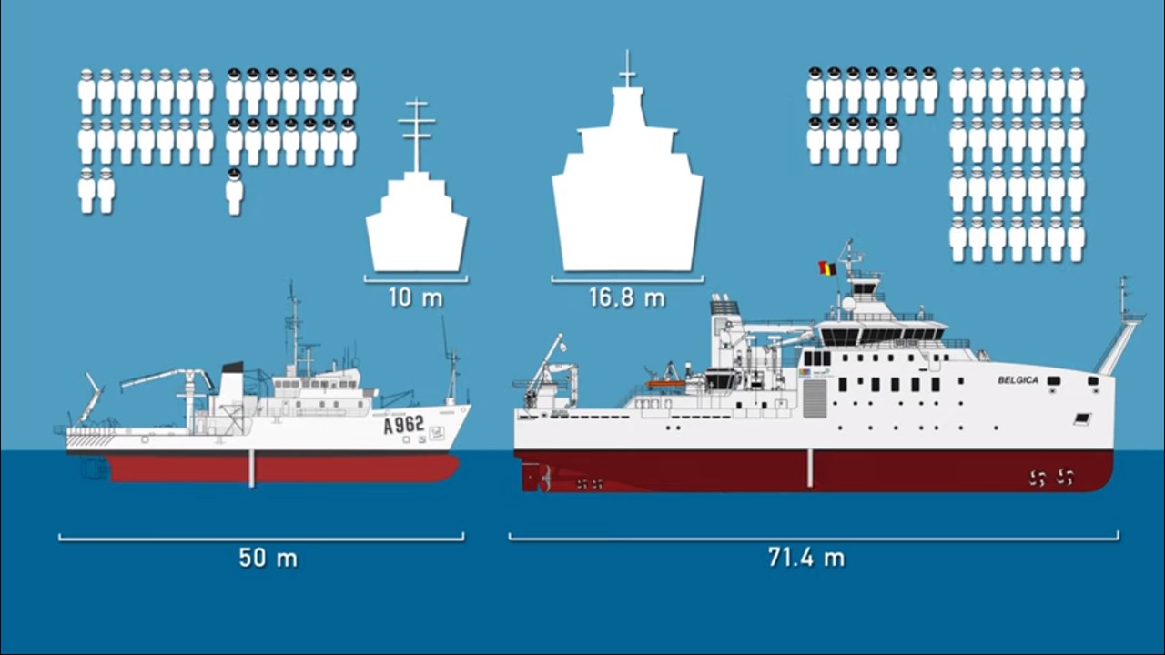
Since Belgium disposed of a marine research vessel in the form of the former RV A962 Belgica (1984 – 2021), our scientists have been punching above their weight in both national and international contexts with regard to marine research and monitoring, marine spatial planning and Blue Economy. The ship also played an important role in the training of marine scientists. The need for a high-performance national research ship cannot be underlined enough. After more than 1,000 scientific campaigns, more than one million kilometres travelled and 37 years of service, the old RV Belgica needed to be replaced so that Belgium can remain at the forefront of marine science and technology.
The new RV Belgica arrived in Belgium on 13 December 2021 and, after the necessary tests and training, started her scientific activities on 27 January 2022. It was the culmination of a long process: feasibility and financial studies on a possible replacement were carried out in the period 2005-2014, on 28 October 2016 the Council of Ministers decided to build a new research vessel, on 31 March 2017 the public contract for the construction was launched, and on 16 March 2018 the contract was finally awarded to the Spanish Freire Shipyard (Vigo). After a design study, the construction started concretely on 13 February 2019 with the cutting of the steel. The keel laying on 27 March 2019 and the first launch on 11 February 2020 were important milestones in the construction process.
The federal government’s departments of Science Policy, Defence and the North Sea not only worked closely together to realise the new RV Belgica, but are also major users and clients of the ship. The ministerial visit of 31 March was filled with a guided tour of the ship and expert explanations about the ship and her missions by Corvette Captain and Captain of the RV Belgica Gaëtan Motmans, and by Dr. Lieven Naudts, coordinator RV Belgica at the RBINS. Finally, the Golden Book of the new Belgica was signed.
Thomas Dermine, Secretary of State for Science Policy: “The new RV Belgica has the most modern equipment on board and has four times more laboratory space than the previous Belgian research vessel. This will allow the scientific community to address new challenges from the Mediterranean Sea to above the Arctic Circle. The RV Belgica will contribute significantly to Europe’s world leadership in marine exploration.”
Vincent Van Quickenborne, Deputy Prime Minister and Minister of the North Sea: “The new Belgica is an icon for the research world and invaluable for North Sea policy. Among other things, it is responsible for monitoring the effects of sand extraction, wind farms and the Paardenmarkt munitions dump. In our North Sea, we are pioneers in many areas: windmills, autonomous shipping, marine spatial planning and also scientific research. With this ship, Belgian scientists can punch above their weight in marine research.”
The cooperation between the policy areas translates into the practical aspects of the operation and management of the RV Belgica: the Belgian Science Policy Office (BELSPO) represents the Belgian State as the owner of the RV Belgica, the Royal Belgian Institute of Natural Sciences (KBIN) manages the calendar, budget and scientific instrumentation of the multidisciplinary research vessel, and the Belgian Navy component provides the bridge personnel and the home port of Zeebrugge. In this way, the cooperation model around the former Belgica, which dates back to the 1960s and can be considered a success, is continued. The new Belgica now also involves a new partner: the private French operator Genavir, which also manages the French oceanographic fleet, is responsible for the integrated management and operation of the ship.
Missions and specifications
The new multidisciplinary RV Belgica guarantees the observance of national and international obligations of our country and ensures the continuity of support to marine sciences (fishery, biology, geology, climate, chemistry, …). Thus, scientific research by universities and research institutes as well as monitoring of the state of Belgian and surrounding marine waters are part of the tasks. The monitoring activities support, among others, a series of dossiers which fall under the competence of Minister for the North Sea Van Quickenborne, such as the national implementation of the EU Marine Strategy Framework Directive and the documentation of the ecological impact of various human activities at sea. In this way, the knowledge necessary to support the Blue Economy is built up. Think for example of sustainable fishing, wind farms at sea, sand and gravel extraction, mining activities in the deep sea, energy storage off the coast, etc. Just like the former RV Belgica, the new research vessel will also be active in the European EUROFLEETS network, which allows international scientists to obtain ship time on foreign research ships.
However, the new RV Belgica also allows the scientific community to focus on new challenges. Indeed, compared to its predecessor, the new ship is larger (71.4 m compared to 50 m), and offers more space to scientists (four times more laboratory space with the capacity to take up to 28 scientists on board). The new RV Belgica is also equipped with state-of-the-art scientific equipment that, among other things, allows samples to be taken to a depth of 5,000 m. It is also a silent ship (important for fisheries research, among other things), with a light ice strengthening to be able to conduct research in Arctic areas during the summer. Although the North Sea remains the main focus area, the research area extends further: northwards to above the Arctic Circle, further south including the Mediterranean and Black Seas, and westwards to the Atlantic Ocean. The vessel has an autonomy of 30 days and will carry out research for up to 300 days at sea each year.
Since the start of operations on 27 January 2022, several research groups have conducted their first scientific campaigns with the new RV Belgica. The experiences were evaluated very positively. So far, the focus has been on the Belgian part of the North Sea, but in 2022, some international campaigns are already on the agenda. This year, the new Belgica will also be active in English, Irish, French, Spanish, Portuguese and Italian waters. For 2023, a first polar expedition is being looked forward to, with Greenland in the crosshairs. The Belgian Navy is also looking forward to many data collected by the Belgica, for example, in the future the new mine-fighting vessels will use Belgica information when searching for mines on the sea floor.
The new RV Belgica will be inaugurated on Saturday, 25 June in the city of Ghent. This will happen in the presence of Her Royal Highness Princess Elisabeth, who accepted to be the godmother of the research vessel. During the weekend of 25 and 26 June, the general public will also have the opportunity to visit the ship and learn more about various scientific activities. The press will receive more details about the full programme, press moments and registration possibilities in due time.
More information on the new RV Belgica can be found on the following websites:
https://www.belspo.be/belspo/NewRV/index_en.stm – Website RV Belgica (BELSPO) – Additional detail on the timeline to the new Belgica, the construction process and specific research projects funded by BELSPO.
EDEN2000 studies: Belgium leading the way in Europe
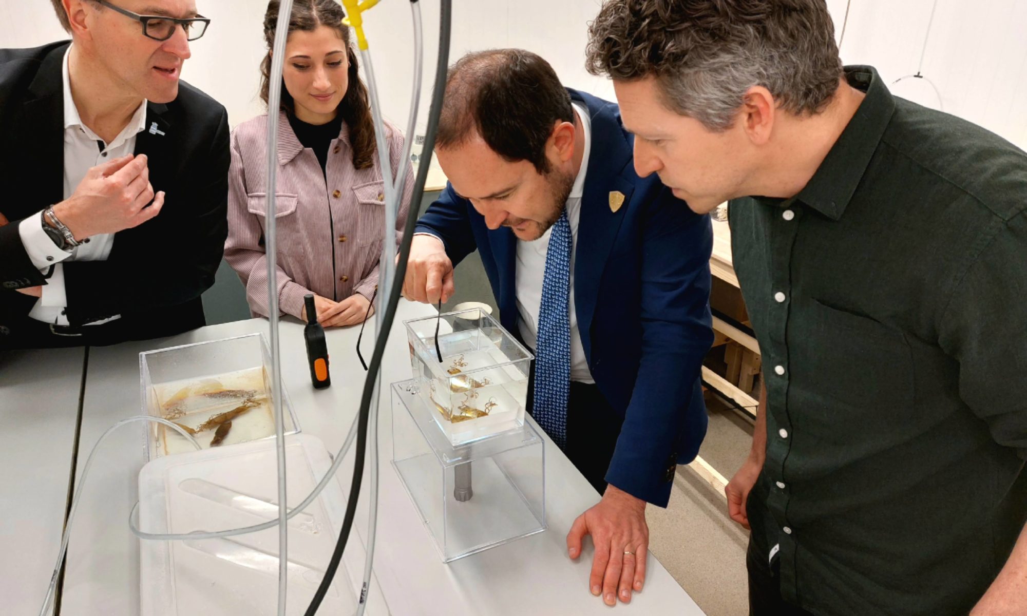
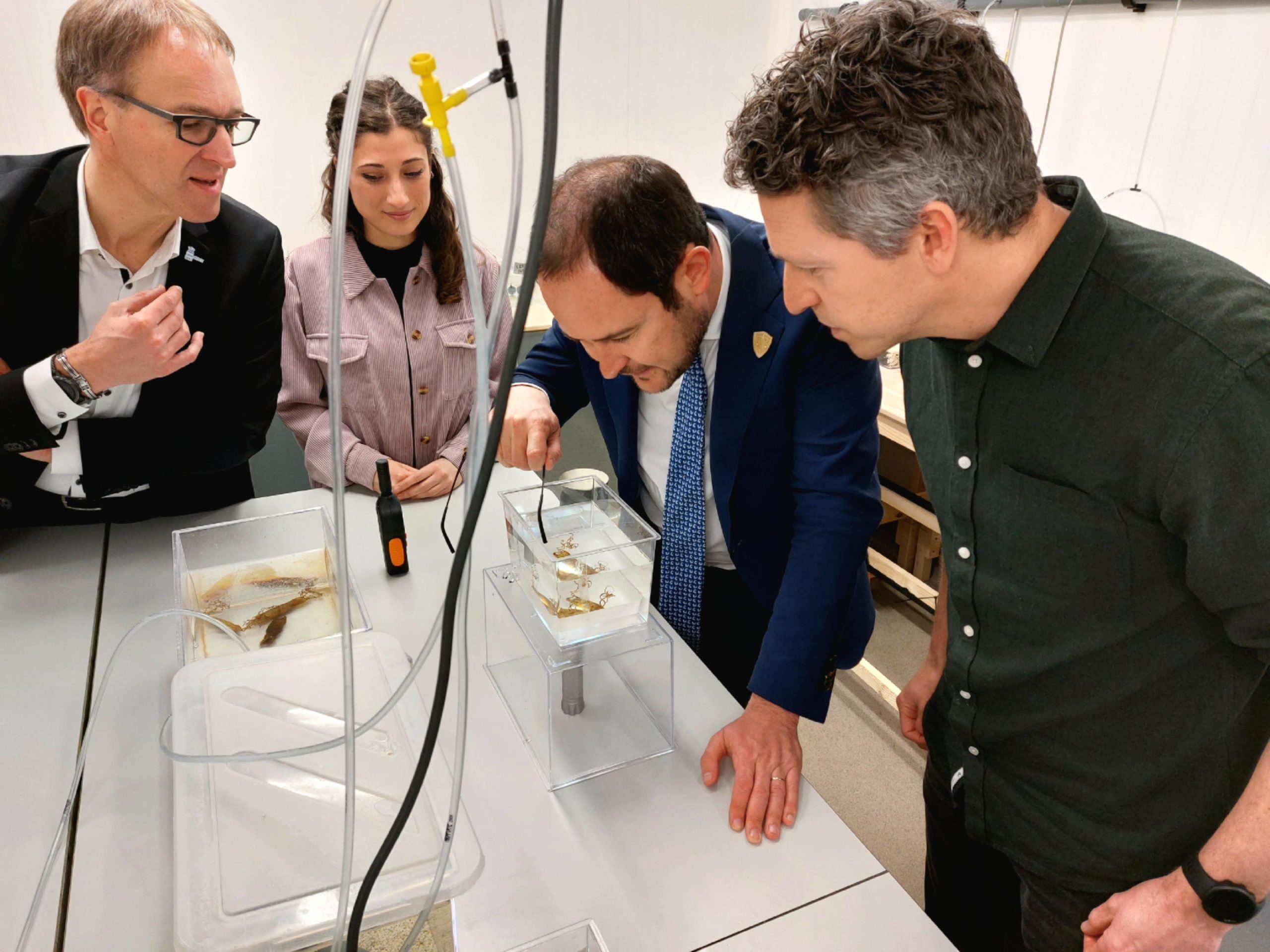
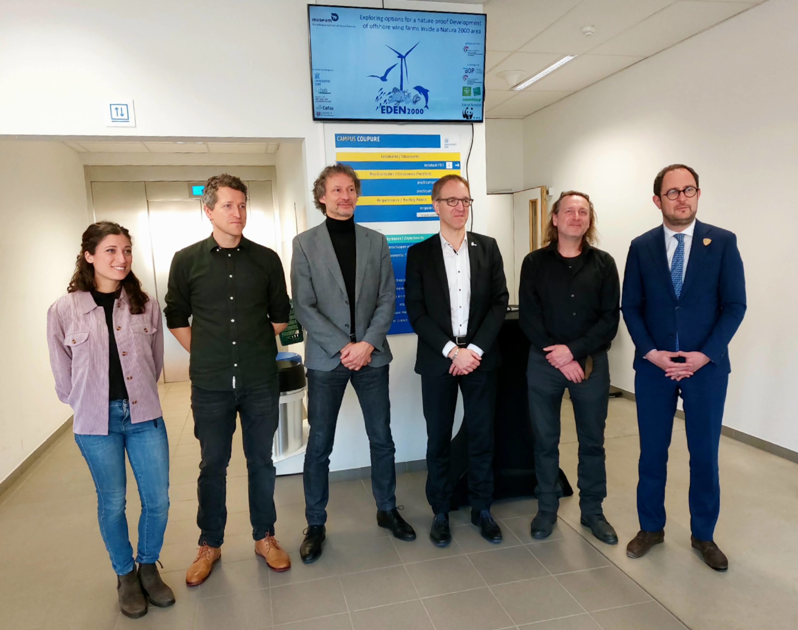
Wind farms at sea are important for our energy supply. The current wind turbines in the Belgian North Sea provide energy for 2 million Belgian households. With the Princess Elisabeth Zone, this share will be increased and all Belgian households will be able to enjoy green energy from the North Sea. In the Marine Spatial Plan 2020-2026, three additional zones have been designated for renewable energy. Two of them are located in or adjacent to a Natura 2000 area, in which the present biodiversity must be extra protected. It is crucial, also for the development of wind farms in these zones, to maintain this protection and even strengthen it where possible. The EDEN2000 project wants to provide an answer to the question of under what conditions we can achieve this through 25 separate studies that are currently underway. These studies will be included in a tender to be put on the market next year. On 22 March 2022, Deputy Prime Minister and Minister of the North Sea Vincent Van Quickenborne visited the UGent Faculty of Agriculture where one of these studies is being carried out. That lab research focuses on the effects of electromagnetic fields on the development of marine animals.
Wind farms at sea are important for our energy supply. The current wind turbines in the Belgian part of the North Sea provide green energy for 2 million Belgian households. This currently makes our country number six in the world in terms of offshore wind capacity. With the new Princess Elisabeth Zone, we are increasing this share and all Belgian households will be able to enjoy green North Sea energy.
The Belgian part of the North Sea already contains 37% nature reserve and our country will now also be the first European country to build wind farms in a nature reserve, more specifically in the Natura 2000 area ‘Vlaamse Banken’. This is an area in which the biodiversity must be extra protected. In particular, the shallow sandbanks and gravel beds form refuges for endangered species such as the Dead man’s fingers (Alcyonium digitatum) and the Mermaid’s glove (Haliclona oculata). Belgium wants to ensure that these nature reserves are not disturbed by the construction of wind turbines and to maintain and even strengthen their protection where possible.
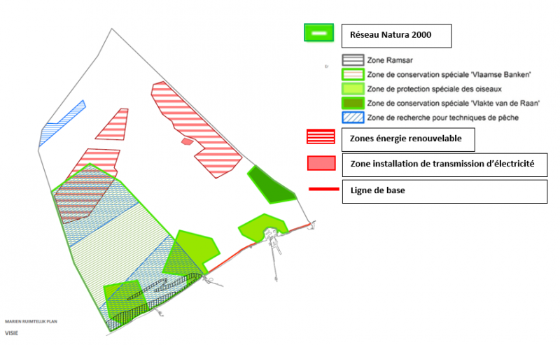
Natura 2000 areas and renewable energy zones. (Source: Marine Spatial Plan 2020-2026)
EDEN2000: research with many aspects
The construction of these wind farms not only requires an environmental permit, but also an additional Natura 2000 permit. This assesses whether or not a project at sea will have significant effects on the species and habitats to be protected.
The Belgian part of the North Sea has been studied closely for a long time. Through the Winmon.be project, the state of the marine environment in the first offshore wind farms has been monitored and a lot of knowledge has been acquired. However, there are still many gaps in the scientific knowledge about the impact of wind farms on nature in the North Sea. These gaps concern both knowledge on how to avoid negative impacts and how to enhance positive impacts.
The EDEN2000 project (Exploring options for a nature-proof Development of offshore wind farms inside a Natura 2000 area) must therefore, via 25 separate studies that were started in 2019 and will be completed by the end of this year, provide an answer to the question of under what conditions we can realise the wind farms in nature reserves.
These include the mapping of gravel beds, the impact on habitat, the influence of wind turbines on seabirds and the impact of techniques and materials used on the biodiversity present.
On 22 March 2022, Deputy Prime Minister and Minister of the North Sea Vincent Van Quickenborne visited the UGent Faculty of Agriculture where researchers affiliated with the Royal Belgian Institute of Natural Sciences (RBINS) and UGent are conducting one of the studies of the EDEN2000 project. The lab research there focuses on the effects of electromagnetic fields on the development of marine animals such as the small spotted catshark (Scyliorhinus canicula), common cuttlefish (Sepia officinalis), European lobster (Homarus gammarus) and common squid (Loligo vulgaris). These species are expected to reproduce successfully again in the gravel beds once the wind farm is developed and bottom-disturbing fishing is eliminated.
Knowledge of the sensitivity of these species to electromagnetic fields, combined with detailed knowledge of the location of the valuable gravel beds, will be used to determine an ecologically sound positioning of cables in the wind farm.
On 18 March, the federal government decided to accelerate the transition to renewable energy with additional investments in offshore wind energy. Minister Van Quickenborne is backing this commitment and points out that the final report of the nature studies will be ready in early 2023.
Vincent Van Quickenborne, Deputy Prime Minister and Minister of the North Sea:“The development of the Princess Elisabeth Zone is important for the energy supply of our country. What makes the Belgian offshore so special is that we will be the first country to build wind turbines in a nature reserve. We can do this because we have already built up a lot of scientific expertise on the environmental impact of wind farms. We will therefore be able to determine the boundary conditions very precisely and strictly in the tender procedure. No fewer than 25 nature studies will be conducted for this purpose.”
Steven Degraer, marine ecologist Royal Belgian Institute of Natural Sciences: “Deploying a thorough scientific knowledge of the marine environment and how it is affected by human activities at sea is the guarantee for an ecologically responsible blue growth. This knowledge not only allows us to avoid negative effects in a very targeted way, but also to reinforce positive effects.”
More information
EDEN2000 is a cooperation between vice prime minister and minister of the North Sea Vincent Van Quickenborne, the Marine Environment Service of the FPS Public Health, the Royal Belgian Institute of Natural Sciences – OD Nature, 4Sea (an umbrella organisation of NGOs) and the Belgian Offshore Platform. The results of this scientific research will be included in the tender conditions for the construction of wind turbines.
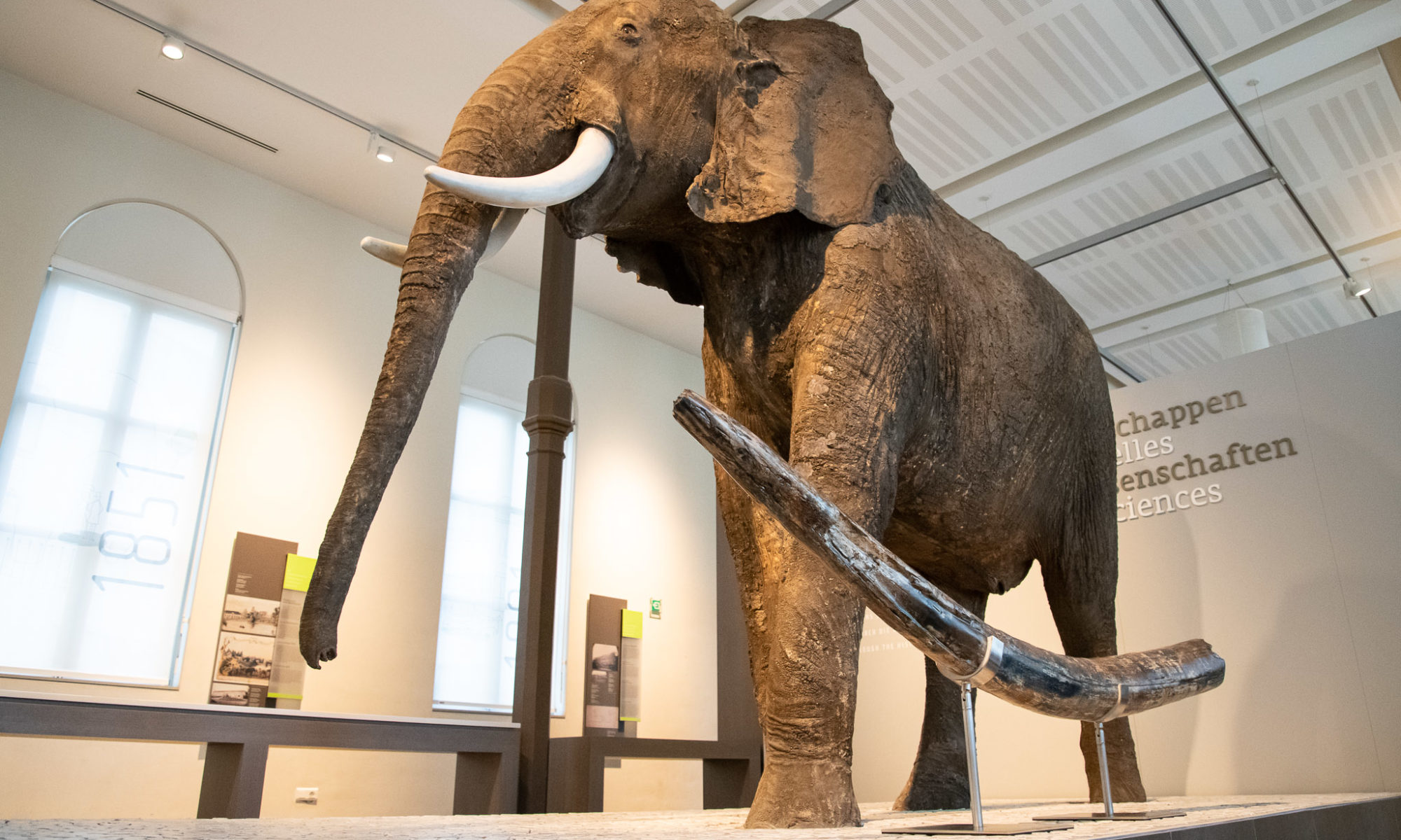
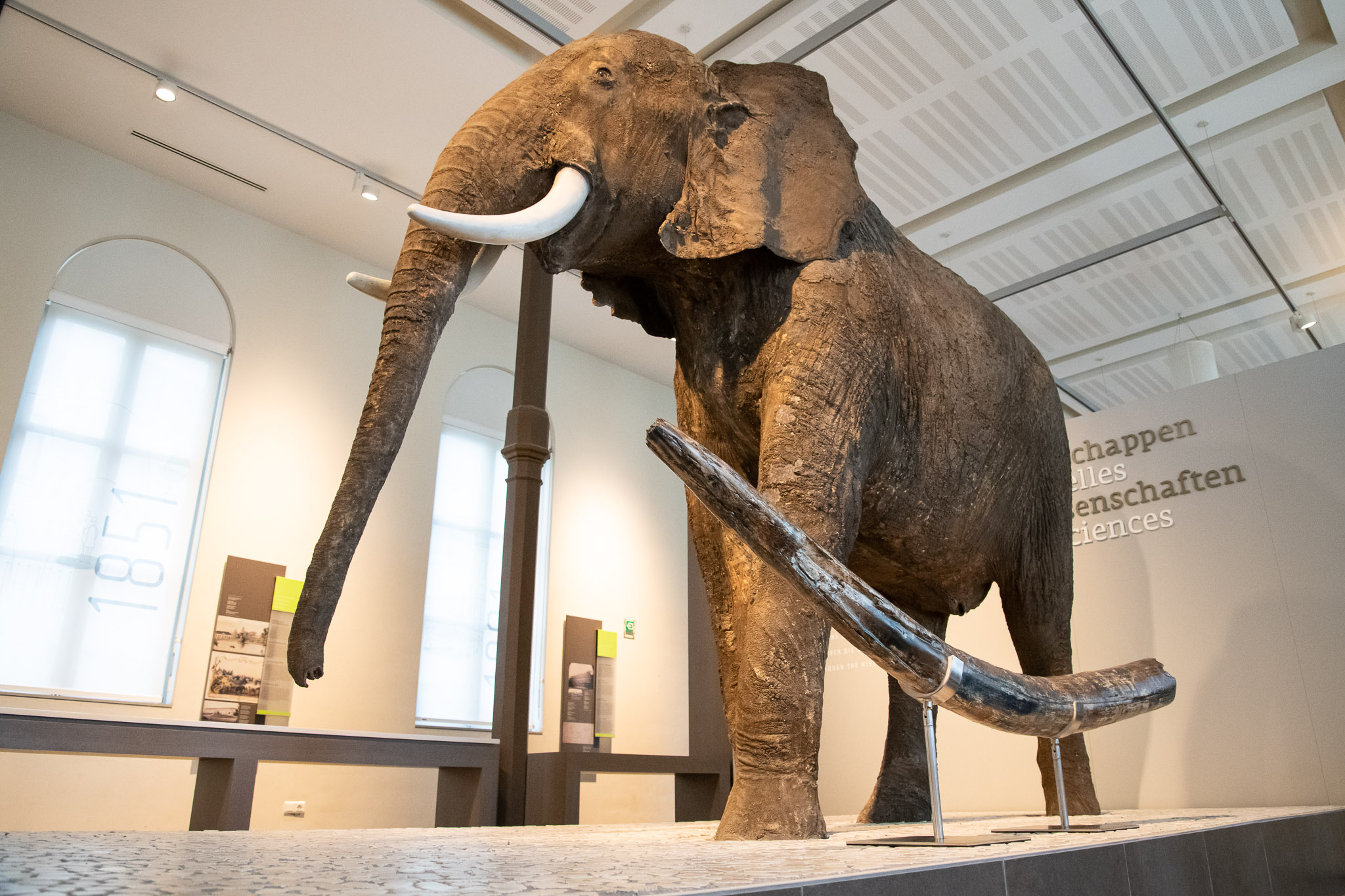
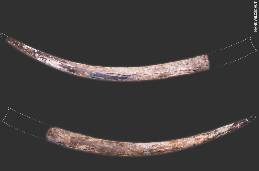
Early July 2020, a Dutch shrimp trawler in Belgian territorial waters hauled up nothing less than an elephant tusk in its nets. The 60 kg, 2.37 m long fossil does not belong to a mammoth, as is often the case in our regions, but appears to have come from a Palaeoloxodon antiquus. This is a type of forest elephant that inhabited the area in between ice ages. It is the first time that such an intact specimen has been found here. The tip and part of the base of the tooth are missing. A reconstruction shows that the entire tusk was more than 2.8 m long. Palaeoloxodon antiquus was a giant that was bigger than the elephants that roam the Earth today! The tusk belongs to an adult male individual about 3.5 metres tall. The age of the fossil is estimated between 130,000 and 115,000 years.
Thanks to the joint efforts of Deputy Prime Minister and Minister of Justice and the North Sea, Vincent Van Quickenborne, and State Secretary for Recovery and Strategic Investments in charge of Science Policy, Thomas Dermine, the Royal Belgian Institute of Natural Sciences was able to add the tusk to its collections. From Tuesday 8 February 2022, the general public can admire the tusk at the Museum of Natural Sciences in Brussels.
The tusks of the contemporary African Bush Elephant (background) are small feat next to the fossil tusk of the straight-tusked elephant (foreground). (Image : RBINS/T. Hubin)
Who was the straight-tusked elephant?
Palaeoloxodon antiquus is a forest elephant that disappeared from our regions before the mammoth. The species was widespread in Europe and thrived mainly during the warmer periods between two ice ages (the interglacials). This discovery is remarkable because there was little evidence of its former presence in Belgium. Palaeoloxodon antiquus was long considered the ancestor of the Asian elephant (Elephas maximus) but is now considered a close relative of the current African forest elephant (Loxodonta cyclotis). Palaeoloxodon antiquus probably originated on the African continent, but it is still little known how widespread this species was in prehistoric times.
Based on the geology of the site, its precise location and the finds of other mammal remains, it is estimated that the tusk dates from the last interglacial period of the Eemian, a period in the Late Pleistocene (approximately 130,000 to 115,000 years ago).
The fossil tusk of the straight-tusked elephant is almost intact, only small parts of the tip and the base are missing.
A trench full of fossils
The tusk was fished in “Het Scheur”, a channel in the Belgian part of the North Sea off the coast of Zeebrugge. Dredging is regularly carried out there to enable large ships to enter the Scheldt or Eurogeul. This causes erosion of the banks of the trench. Many mammal fossils have come to the surface in this way. These include the remains of the southernmost Pleistocene walrus colony in the world, the bones of ancient whales that swam here tens of millions of years ago, and the remains of mammoths.
The region where the tus kwas found has changed dramatically in appearance throughout history. It has alternated between sea and land, was covered by an icecap during ice ages, and was a tidal landscape with forests in between the ice ages. This explains why many fossils of very different organisms are found here. However, a tusk of a straight-tusked elephant tooth was never among them.
The fact that this tusk has remained intact is thanks to the fishing method. When fishing for shrimp, no chains are used and the bottom of the net rolls freely on and over the bottom thanks to rubber “wheels”. The shrimp roll in while the net remains free of stones and other unwanted bycatch. Fossils are very rarely caught with this type of net.
A detour to the Museum of Natural Sciences
The Dutch fishermen sold the tusk to North Sea Fossils, a private fossil dealer in Urk, the Netherlands. Afterwards, it was initially studied by researchers associated with the Rotterdam Museum of Natural History.
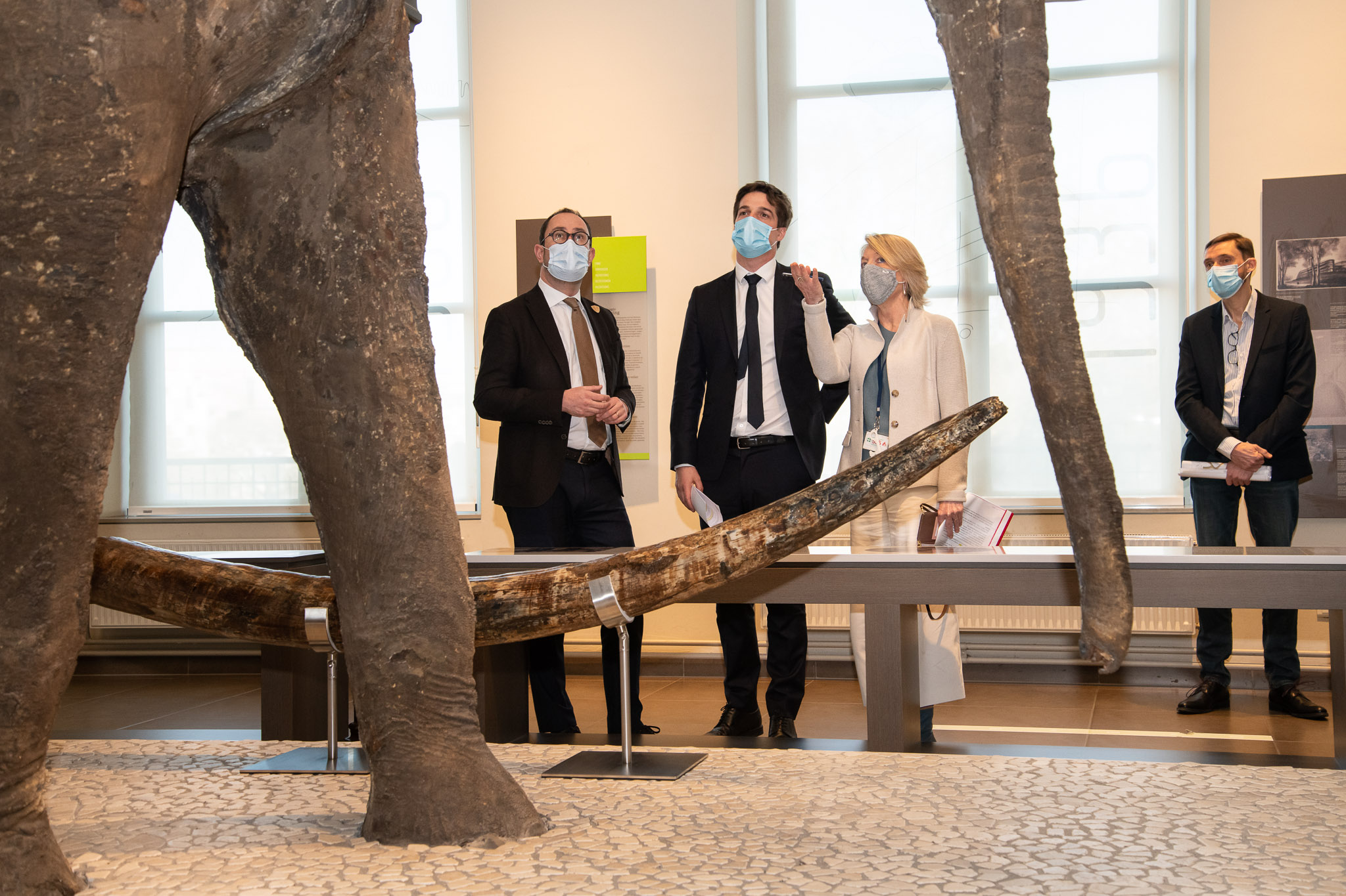
Thanks to the joint efforts of the Minister for the North Sea, Vincent Van Quickenborne, and the State Secretary in charge of Science Policy, Thomas Dermine, negotiations were started to recover the Belgian fossil. Finally, the Royal Belgian Institute of Natural Sciences was able to include the tusk in its collections, where it will remain available for research and is also made accessible to the public. From Tuesday 8 February 2022, the general public will be able to admire the tusk at the Museum of Natural Sciences in Brussels. The signing of the declaration of donation took place on 7 February 2022, on the occasion of the inauguration of the fossil tusk.
Minister Van Quickenborne, State Secretary Dermine and General Director Supply admire the tusk of the straight-tusked elephant in the Museum of Natural Sciences. (Image: RBINS/T. Hubin)
A new cooperation agreement
The discovery of the fossil tusk was also the occasion for drawing up a cooperation protocol within the framework of the law on the implementation of the UNESCO Convention of 2 November 2001 on the protection of underwater cultural heritage and the protection of valuable shipwrecks. In this agreement, the Governor of West Flanders, the Directorate General of Maritime Affairs (FPS Mobility and Transport), the Royal Belgian Institute of Natural Sciences, the Flemish Heritage Agency and the Flanders Marine Institute henceforth formalise the cooperation regarding the protection of the underwater cultural heritage, including the paleontological heritage, and the protection of valuable shipwrecks. The agreement ensures that future discoveries at sea will also be recorded, studied and, where necessary, made accessible to the public.
Minister Van Quickenborne:“Our North Sea reveals its treasures only sparsely. Yet the objects we find there are an important part of our heritage. Since last year, we have a new law that automatically protects heritage older than 100 years. More than 55 historic shipwrecks have already been recognised. Thanks to this law, we can now also include fossils in our heritage. The signing of the cooperation agreement is the final piece of this new law. In this way, the tusk of the straight-tusked elephant will not disappear into a private archive. Instead we can let everyone enjoy the richness of our North Sea heritage. At the same time, the scientists connected to the RBINS can research it and thus refine their knowledge of the prehistory in our regions.”
Secretary of State Dermine:“The fossilised tusk of a straight-tusked elephant, which was found off the coast of Zeebrugge, has, after a short wander, found its way to where it belongs. The RBINS is Belgium’s most important research centre for palaeontology and is renowned worldwide. The fossil, which is more than 115 000 years old, is being studied at the RBINS and is linked to other treasures in the huge collection of no less than 3 million fossils. This way, it forms a piece of the puzzle in the picture of life in our regions in ancient times, which is brought to life in the Museum of Natural Sciences. From 8 February onwards, the tusk can be admired by the 350,000 visitors who come to the Museum every year.”
General Director a.i. RBINS Patricia Supply: “Earth sciences, including palaeontology but also geology and archaeology, have always been an important field of research at the RBINS. It has allowed us to build up a reputable level of palaeontological knowledge and expertise. The acquisition and exhibition of the tusk of a forest elephant is closely linked to the objectives of the RBINS: in addition to scientific research and services, the management and development of heritage and scientific collections, and the dissemination of knowledge in the natural sciences are also core tasks of the institute. Today, the tusk is given a very prominent place in our museum, near the mammoth of Lier and the African elephant that once lived in the Brussels zoo.”
In a new annual report, the scientists that monitor the environmental impact of offshore wind farms in the Belgian part of the North Sea summarise their latest findings. Once again, some surprising revelations are included. The results show that life in and around the wind parks has not yet reached stability 13 years after construction. Examples include that the biodiversity of fouling communities on wind turbines increases again after a decline in previous years, and that seabird movements are more spatially and temporally variable than previously known. The risk for songbird collisions is now better understood, and mitigation measures are proposed for periods of intense bird migration. Artificial reefs between turbines keep developing, with some fish species being attracted to the growing amount of food that these provide. Echolocation data indicate that underwater noise mitigation measures effectively reduce the impact of pile driving on harbour porpoises.
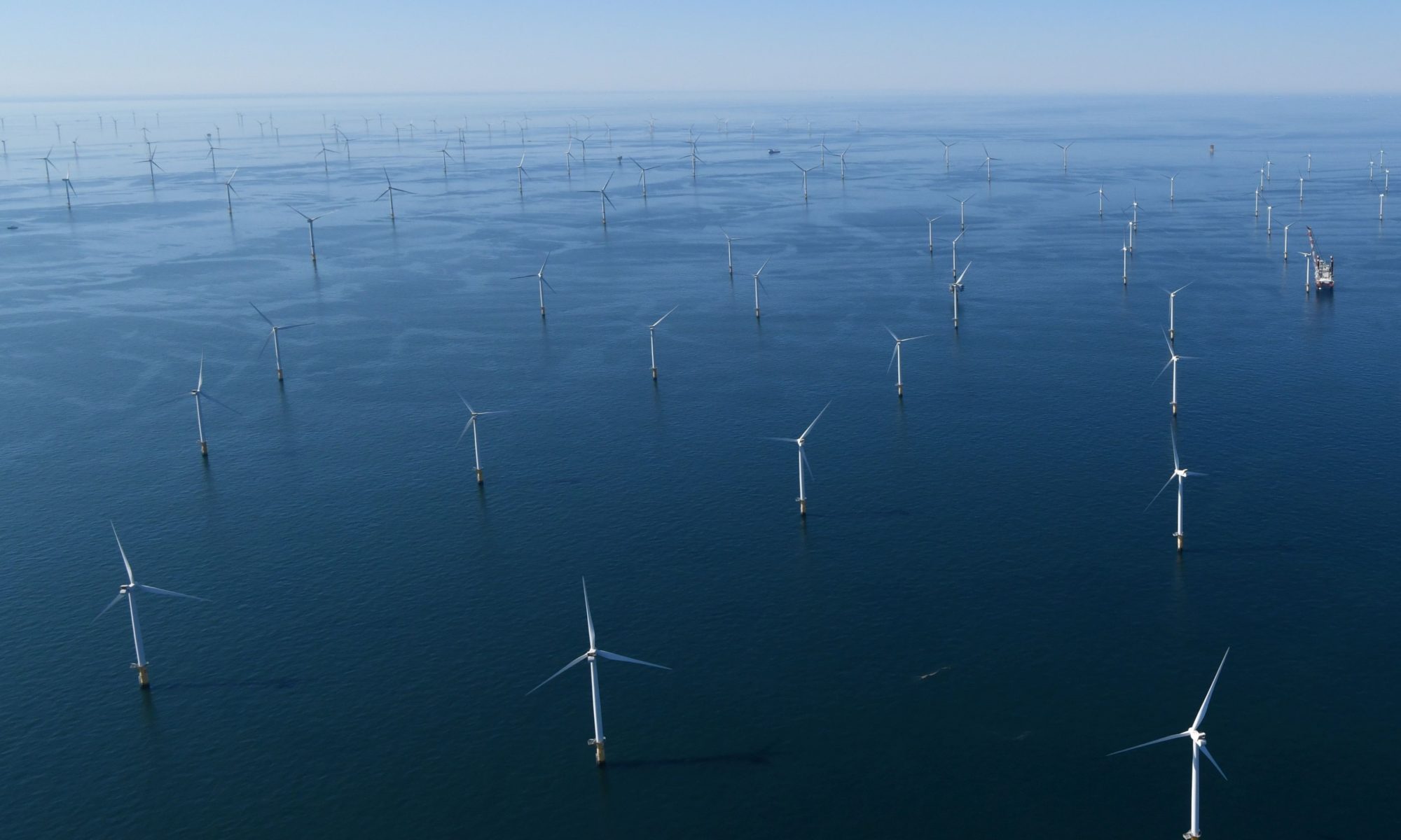
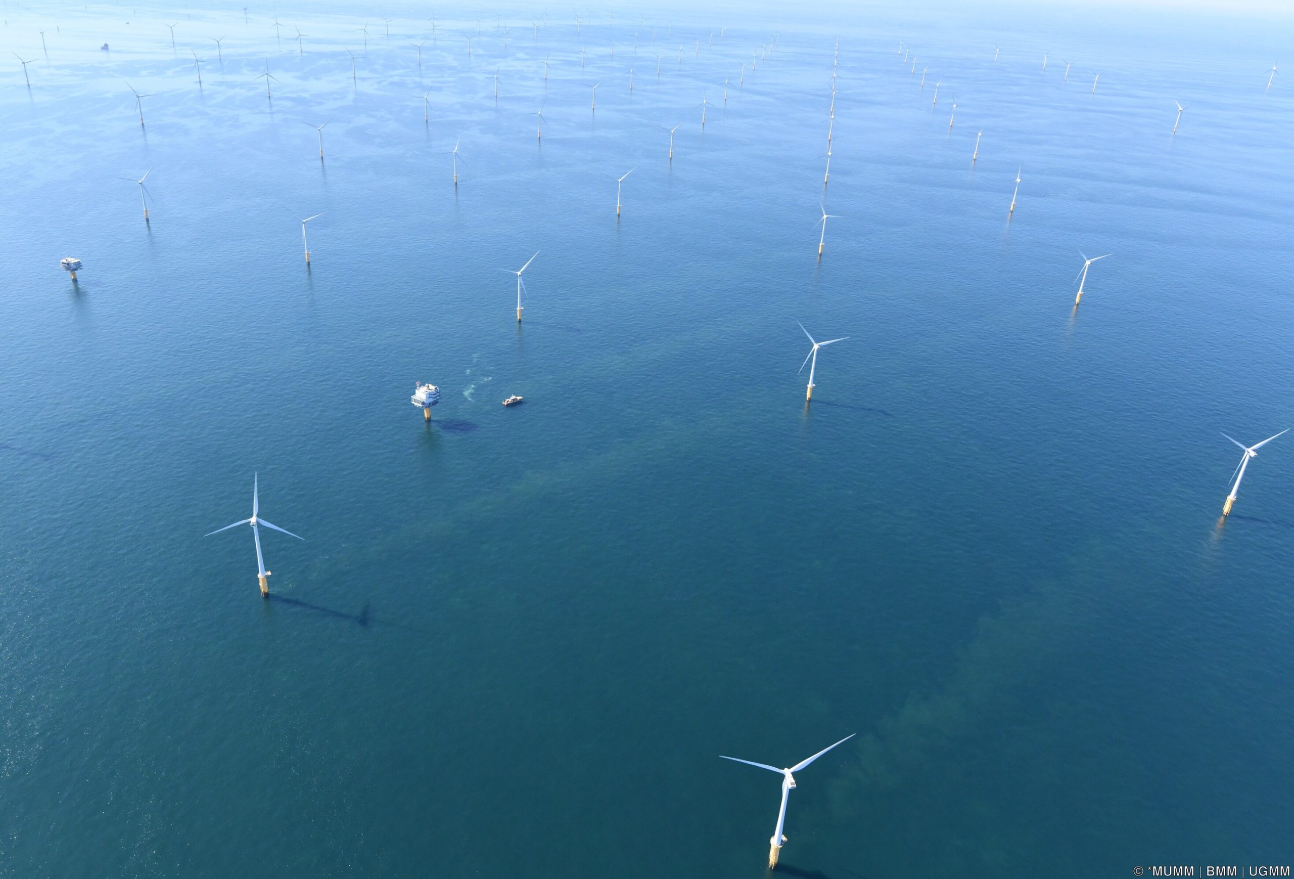
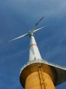
On 31 December 2019, Belgium submitted a National Energy and Climate Plan to the European Commission which envisions a target figure of 17.5% for the contribution of the production of electricity from renewable energy sources by 2030. Offshore wind farms in the Belgian part of the North Sea are expected to make an important contribution to achieve that goal. They are in fact already doing so, as currently 10 % of the total Belgian electricity demand, or 50% of the electricity demand of all Belgian households, is already produced by offshore wind farms. This is realised by a total of 399 turbines in eight wind farms, grouped in a zone of 238 km² along the border with the Netherlands. After 12 years of construction, this zone was fully operational from the end of 2020 and accounts for an installed capacity of 2.26 Gigawatts (GW) and an average production of 8 TWh. This puts Belgium in the 5th place worldwide in the production of this form of energy. A second area for renewable energy of 285 km² is foreseen by the new Belgian marine spatial plan (2020-2026), aiming for an installed capacity of 3.1 to 3.5 GW in this zone.
Zones for renewable energy, including offshore wind farms, in the Belgian part of the North Sea. Eastern zone = first phase that is completely operational, western zone (Hinder North, Hinder South and Fairybank) = second phase, construction foreseen from 2023 onwards (source: Marine Spatial Plan 2020-2026).
Science, policy and industry pulling in the same direction
Prior to installing a wind farm, a developer must obtain a domain concession and an environmental permit. The environmental permit includes terms and conditions intended to minimise and mitigate the impact of the project on the marine ecosystem. As required by law, the permit also imposes a monitoring programme to follow up the effects on the marine environment.
For offshore wind farms in the Belgian part of the North Sea, the monitoring programme WinMon.BE documents the extent of the anticipated and unexpected impacts on the marine ecosystem and aims at revealing the processes behind these impacts.
Growing insight into the environmental impact
The WinMon.BE scientists started monitoring the impact of offshore wind farms in Belgium at the start of the construction of the first wind turbines in 2008. This has allowed them to develop extensive knowledge and expertise with regard to the monitoring methods and the actual environmental impact. “Belgium now has the longest time series of data on the environmental impact of offshore wind farms in the world, and many countries are looking at the Belgian example for inspiration to start up similar programmes.” says Steven Degraer (RBINS/MARECO), coordinator of the WinMon.BE consortium. “The time series has already revealed unique insights but we are still regularly confronted with surprising results that lead to new knowledge. This illustrates the importance of maintaining the follow-up effort in the long term and substantiates why we need to remain flexible in our interpretations and in adjusting human activities at sea.”
In their latest report, the WinMon.BE partners present an overview of the newest scientific findings of the Belgian offshore wind farm environmental monitoring programme, based on data collected up to and including 2020. They zoom in on patterns of attraction, avoidance and habitat use at various spatial scales (wind farm-, turbine- and microhabitat-scale) and across different ecosystem components (marine mammals, birds, fish and invertebrates that live on the seabed and turbines), and demonstrate the benefits of the increasing knowledge to design appropriate measures to mitigate undesired impacts or promote desired effects.
Overview of the results
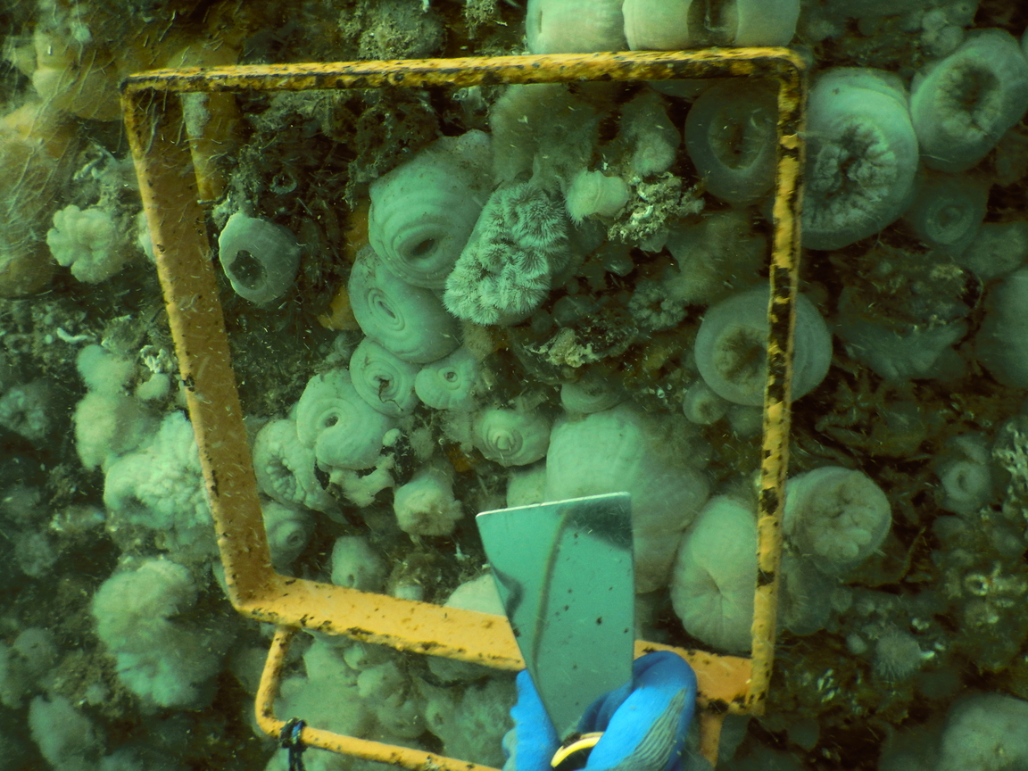
Effects on the seabed and the associated life
The start of the monitoring in the wind farm closest to the coast showed that this area harbours very diverse seafloor-inhabiting biological communities. The response of these valuable communities to long-term turbine presence and fishery exclusion will be carefully followed up in the next years.
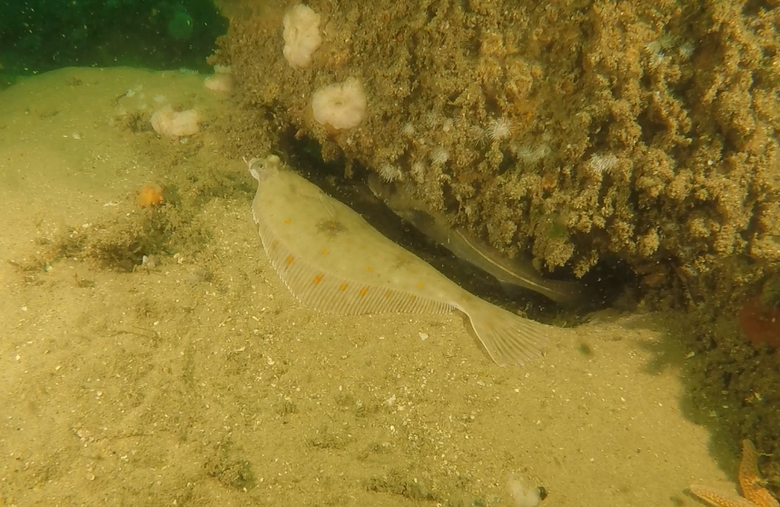
In the longer-established wind farms, the colonisation by marine organisms and the effects on the seabed were continuously monitored. Initially, colonisation by invertebrates and fish with a preference for hard substrates in the immediate vicinity of individual wind turbines was particularly noticeable. Ten years after construction, it is now observed that these local effects are expanding towards the soft sediments in between the turbines. Artificial reefs are being formed, with more epibenthic and fish species that are associated with hard substrates now also dwelling on the soft sediments. The species involved include blue mussel (Mytilus edulis), anemones, common starfish (Asterias rubens), green sea-urchin (Psammechinus miliaris), hairy crab (Pilumnus hirtellus) and European seabass (Dicentrarchus labrax). For epibenthic species, this also leads to significantly higher overall densities and biomass inside the farms.
Attraction of fish to the offshore wind farms mainly takes place at the scale of individual turbines. Plaice (Pleuronectes platessa), a commercial flatfish species, is attracted to the sandy patches between the scour protection layer around offshore wind turbines, as they provide optimal food and shelter opportunities. Benthopelagic fish like pouting (Trisopterus luscus) and cod (Gadus morhua), that traditionally linger around the turbines and their foundations, were already previously shown to be attracted to the developing artificial reefs, as these offer excellent feeding opportunities for these species.
In the maturing biofouling communityon the turbine foundations, species interactions start playing an important role. Shells of blue mussels provide secondary hard substrate habitat attractive to colonizing organisms, and thus contribute to an increase in species diversity. A comparison of the species composition of the early (mussels not prevalent) and mature (mussels prevalent) colonizing communities showed that 21 out of 47 identified species were uniquely growing on mussel shells. These were all sessile species, mainly molluscs, arthropods, annelids and bryozoans. This effect counteracts the impoverishment of species richness that was found before as result of the abundant presence of the plumose anemone (Metridium senile).
Pile driving activities during the construction of offshore wind farms causes considerable noise pollution. Harbour porpoises (Phocoena phocoena), well established cetaceans in the Belgian part of the North Sea, are known to avoid areas with excessive sound levels. Therefore, the application and effects of potential mitigation measures received much attention. By comparing acoustic monitoring datasets from 2016 (when no mitigation was applied yet) and 2019 (application of Double Big Bubble Curtains) it was determined that underwater noise mitigation measures effectively reduce the spatial and temporal extent of avoidance of the construction area by harbour porpoise.
And above the water surface?
Displacement of seabirds caused by offshore wind farms has proved to be a complex process. Attraction to and avoidance of wind farms by seabirds has multiple causes including visual disturbance induced by the turbines and the presence of offshore rest and foraging opportunities, and may in part also be explained by the absence of fisheries in Belgian wind farms. The ongoing monitoring now starts to provide more insight in the spatial and temporal variation of seabird responses. Spatial variation may result from differences in local habitat quality, wind farm size and configuration as well as its location relative to bird colonies and favoured feeding grounds. Temporal variation may depend on the life cycle of the species. In this context, it now appears that GPS-tagged adult lesser black-backed gulls (Larus fuscus) from nearby breeding colonies are not attracted by the Norther wind farm, while the conspecifics that were shown to be attracted to the more offshore Belwind farm included migrating and immature individuals. In the longer term, some seabirds may also habituate to the presence of offshore wind turbines. This could be the case for northern gannet (Morus bassanus), common guillemot (Uria aalge) and razorbill (Alca torda), that seemed to avoid the wind parks in the past but were all present in good numbers during the most recent monitoring survey.
When flying at rotor height, migratingsongbirds are also at risk of collision with offshore wind turbines. The intensity of songbird migration is especially high at night, as was confirmed by continuous bird radar surveys in a Belgian offshore wind farm. The collision risk increases when weather conditions deteriorate. An effective measure to reduce bird collisions is to temporarily idle turbines when these events occur at wind turbine rotor height. A modelling study shows that a total of 682 songbird collisions would have been avoided in autumn 2019 if the turbines of all Belgian offshore wind farms had been idled when bird fluxes exceeded 500 birds per km and hour at rotor height. Although we don’t know what species are concerned, it is unlikely that these songbird collisions have a significant effect at the population level. Whether this will still be the case for the cumulative effects of all planned wind farms in the North Sea is unknown at this time.
The Monitoring Programme WinMon.BE is a cooperation between the Royal Belgian Institute of Natural Sciences (RBINS), the Research Institute Nature and Forest (INBO), the Research Institute for Agriculture, Fisheries and Food (ILVO) and the Marine Biology Research Group of Ghent University, and is coordinated by the Marine Ecology and Management team (MARECO) of the Royal Belgian Institute of Natural Sciences.
WinMon.BE is commissioned by the Federal Government as part of the environmental permit conditions for offshore wind farms. For the monitoring, use was made of the research vessel Belgica (ship time on RV Belgica was made available by BELSPO and RBINS – OD Nature), the research vessel Simon Stevin (operated by the Flanders Marine Institute) and the observation aircraft of RBINS.
No doubt you have all heard the great news : The new RV Belgica has safely arrived in Belgium on 13 December 2021, all tests, training, checks and paperwork were completed and, above all, the scientific activities have started!!
Time to feed the enthusiasm of future users and visitors, as well as all sympathisers, with a brand new teaser video !!
The honour of starting up the scientific activities went to RBINS : on Thursday 27 January, RV Belgica set sail for scientific programmes under the supervision of our colleagues Michael Fettweis (Biogeochemical monitoring of suspend particulate matter within hydrodynamic boundary conditions) and Xavier Desmit (Biogeochemical particle interactions and feedback loops on the Belgian Continental Shelf).
For more information on the RV Belgica, her programme and activities, please visit the updatedwebsite:


 On 31 December 2019, Belgium submitted a National Energy and Climate Plan to the European Commission which envisions a target figure of 17.5% for the contribution of the production of electricity from renewable energy sources by 2030. Offshore wind farms in the Belgian part of the North Sea are expected to make an important contribution to achieve that goal. They are in fact already doing so, as currently 10 % of the total Belgian electricity demand, or 50% of the electricity demand of all Belgian households, is already produced by offshore wind farms. This is realised by a total of 399 turbines in eight wind farms, grouped in a zone of 238 km² along the border with the Netherlands. After 12 years of construction, this zone was fully operational from the end of 2020 and accounts for an installed capacity of 2.26 Gigawatts (GW) and an average production of 8 TWh. This puts Belgium in the 5th place worldwide in the production of this form of energy. A second area for renewable energy of 285 km² is foreseen by the new Belgian marine spatial plan (2020-2026), aiming for an installed capacity of 3.1 to 3.5 GW in this zone.
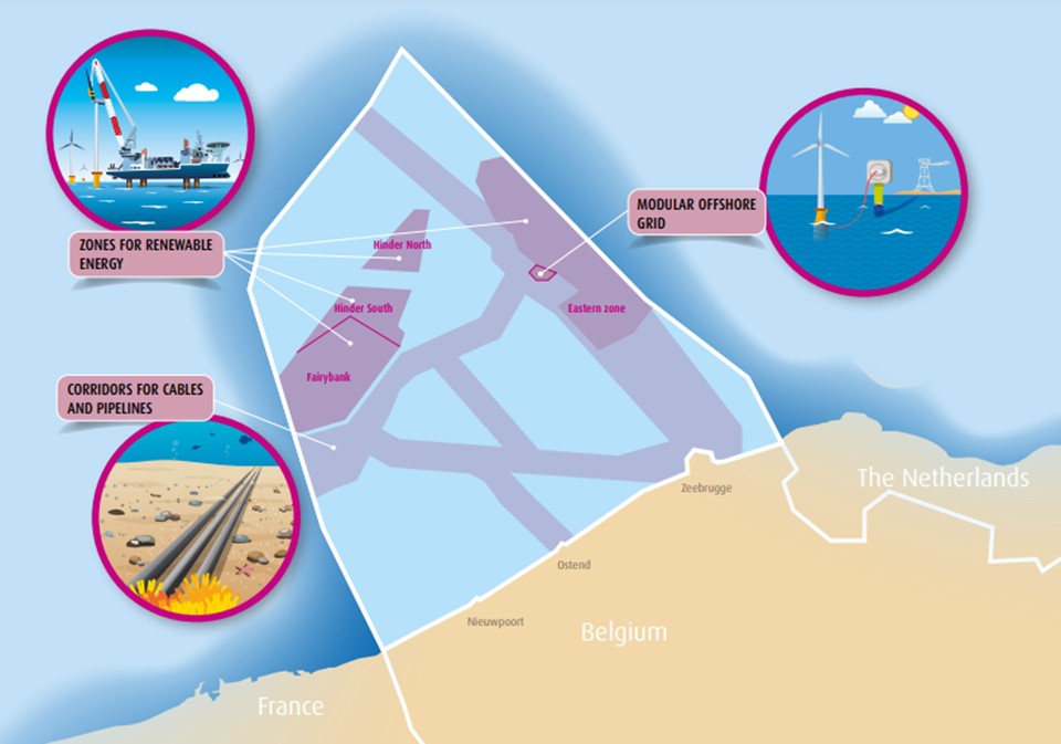
 In their