
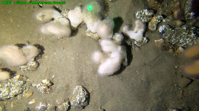
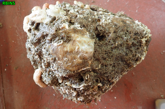
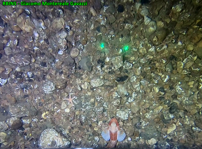
Scientists of the Royal Belgian Institute of Natural Sciences discovered a hotspot for underwater life in the Belgian part of the North Sea. In the farthest offshore Belgian waters, beneath one of the busiest shipping lanes of the world, full-fledged colonies of long-living fauna, linked to a seafloor composed of considerable amounts of rocks and stones, were found. Ecologically important species have been observed, including numerous colonies of the soft coral ‘dead man’s fingers’. The gravel bed also housed the first living specimen of the European flat oyster on the Belgian seabed in decades. In Belgium, this species has recently only been found on artificial structures such as wind turbines and quay walls.
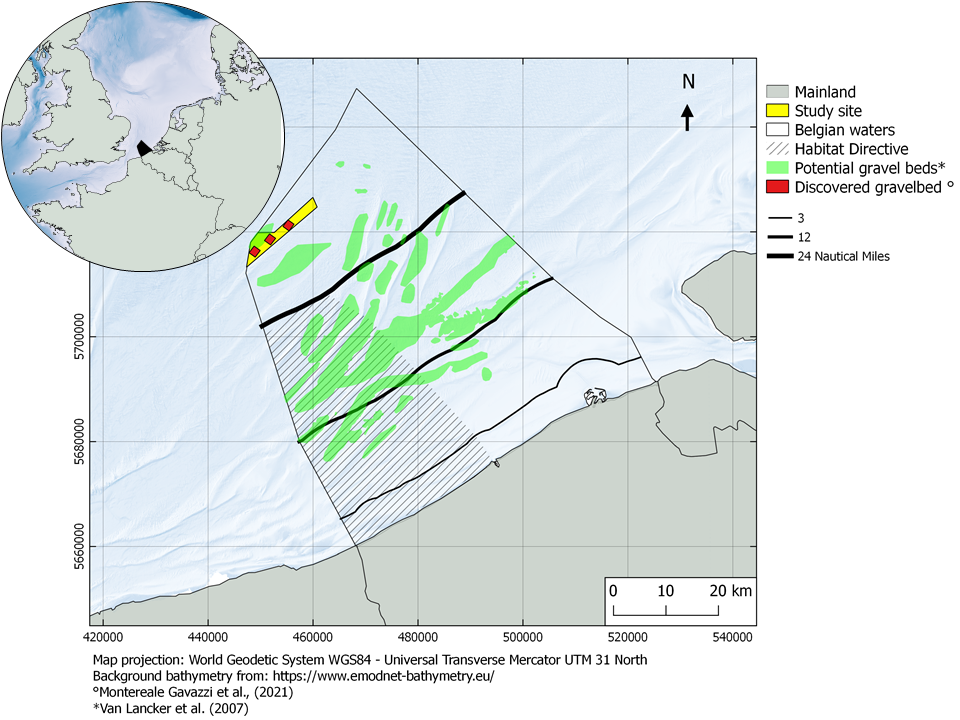
The Belgian part of the North Sea represents a small portion of the Greater North Sea, covering only about 0.6 % of its surface area. Despite its size, the diversity and extent of human commercial activities, ranging from intense routed navigation, commercial fisheries, to infrastructural development for the production of renewable energy, and the extraction of marine sands, result in amongst the most intricate marine spatial plans of Europe. Belgian waters are known as a predominantly sandy seafloor environment, renowned for the widespread presence of large sandbanks, historically known as a major hazard to navigation.
It’s not just Sand in the Belgian North Sea
Nonetheless, the existence of natural hard substrates, generally referred to as gravel beds and composed of lag deposits (leftover coarse sediments from which the finer material was washed out by wind, currents, tides), pebble, cobble, and boulder stones, has been known for long, and is relatively well documented both historically and recently. Regional sediment distribution maps show that approximately 15% of the Belgian seafloor consists of potential gravel beds, the majority of which are to date, geologically and biologically unexplored. Globally, the ecological relevance of this substrate type is an undisputed fact as, under the right conditions, stones can become home to a diverse fauna and flora, creating biological reefs, and representing ecologically unique areas within the otherwise vast and predominantly sandy and muddy seafloor.
The earliest available documentation linking the Belgian ‘stony’ grounds with a highly distinctive fauna originates from the 20th century explorations (1898 – 1939) of Professor Gustave Gilson, a Belgian pioneer oceanographer and former director of the Royal Belgian Institute of Natural Sciences (RBINS). However, our gravel areas have greatly diminished due to intensive and pervasive fishing activities, ploughing the sediment, and overturning the stones, and in places, even removing them from their natural location by direct harvesting along with the fish catch, resulting in loss of this unique habitat. After all, stones from the North Sea can be very decorative (a.o., because of the calcareous overgrowth of tube worms, making these stones, to some, an embellishment of the garden) and removing them from a fishing ground eliminates the risk of damage to the nets when they are recaptured. The resulting process of habitat degradation is such that the gravel bed habitat, and several of its typical species, have been brought to the brink of local extinction. A characteristic example of species loss from these offshore grounds, mainly due to overexploitation, is that of the once proliferating European flat oyster (Ostrea edulis), a species of high ecological importance, but also of great commercial interest.
Favourable Ecological Conditions
Despite the overall degraded state of the Hinder Banks gravel beds, recent research by scientists of the Royal Belgian Institute of Natural Sciences has documented the existence of various small refuge areas with fragile and resilient typical fauna. Therefore, a large area of the Hinder Banks gravel beds was designated as a ‘Special Area of Conservation’ (Vlaamse Banken) in 2012 and became part of the Belgian Natura 2000 network.
Over the past four years, extended research on the distribution of the gravel bed areas in the farthest offshore Belgian waters beyond the Hinder Banks region led to the discovery of a natural gravel bed habitat in seemingly favourable ecological conditions, right beneath the main shipping lane. Using state-of-the-art oceanographic instruments on board the former Research Vessel A962 Belgica, 5 km2 of this “underwater biodiversity hotspot” was mapped and observed with unprecedented detail.
The seemingly favourable ecological conditions are inferred from the widespread presence of typical gravel bed species colonising the stones, including numerous colonies of the soft coral dead man’s fingers (Alcyonium digitatum; approximately 200 colonies / 80 m2). Additionally, it was the first time in decades that a live specimen of the European flat oyster was recorded from the Belgian seafloor. This species has recently only been found in Belgium on artificial structures such as wind turbines and quay walls.
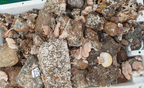
Other ecologically important species include a range of bivalve and gastropod shells, crustaceans, fish, sea chervil (Alcyonidium diaphanum), hornwrack (Flustra foliacea) and sea beards (Nemertesia antennina).
Such an area is highly ecologically relevant: hard-substrate habitats provide unique ecosystem services. The structural complexity of stony seafloors provides microhabitat for a range of animals which live either attached on the stones or amongst the created cracks and crevices. Organisms that live attached to the stones can have quite complex morphology, often resembling plant structures, which can serve as a secondary substrate for other organisms to attach. Such biogenic substrates can be soft or hard and are created by various animals, from reef and tube-building worms to erect and arborescent hydrozoans and bryozoans. This increased structural complexity not only promotes the occupancy by a diverse fauna, but also acts as ideal spawning and nursery ground, shelter and/or feeding areas for several other species in their various life stages. Since many of these animals feed by filtering the water mass, they contribute to waste remediation and water clarity. Indeed, where foundation species such as kelp forests, seagrasses and macroalgae canopies are scarce, as for the predominantly sedimentary seafloor of the Southern North Sea, the ecological importance of hard substrate-habitats increases substantially.
Sheltered by a Shipping Lane
Given the turmoil of human activities, of which commercial fishing in particular, the discovery was surprising. Indeed, inspection of regional commercial fishing intensity maps in this study area, accounting for the activity of Belgian, French, Danish, German, Dutch, and British fleets, showed that a fishing hotspot exists here, as the area is fished more than five days every year. However, a more detailed investigation of the local fishing patterns revealed that activities are mostly limited to the use of passive and mid-water gears, with only a minor use of bottom destructing gears. This suggests that the busy shipping lane perhaps acts as a prevention against bottom disturbing fishing activities, allowing for the typical fauna to develop. The discovery was made in one of three search zones for seabed protection that have been laid down in the Marine Spatial Plan 2020-2026 of the FPS Health, Food Chain Safety and Environment. In these search zones, it is possible to install protection zones for bottom integrity, which is currently being worked on. The aim is to protect valuable natural elements by only allowing fishing techniques that do not disturb the seabed.
The scientific findings on the detailed mapping of the natural gravel bed and ecological analysis are summarised in a 2021 paper published in the Journal of Remote Sensing. In this study, underwater acoustics and videography were combined to map the habitat’s distribution and to study the effect of stone size with respect to their colonisation by the typical fauna.
“We are currently continuing to monitor this new area and the Hinder Banks region, now using the new RV Belgica“ Giacomo Montereale Gavazzi, first author of the publication, says, “but the discovery already suggests that biological communities that are associated with gravel beds can persist and recover in Belgian waters”. In the framework of future marine spatial planning and nature conservation and restoration, “this area may serve as an example for this habitat elsewhere in Belgian waters and generally, in the wider Southern North Sea region”. Moreover, “The fact that such animals exist in this area raises the expectation that shipping lanes throughout the North Sea could represent corridors of natural hard substrate biodiversity hotspots”.
Vincent Van Quickenborne, Deputy Prime Minister and Minister of the North Sea: “For the first time in decades, a living specimen of the European flat oyster has been found on the Belgian seabed. This find is all the more special because it was made in a gravel bed in ecologically good condition under one of the busiest shipping lanes in the world. This is a zone where anchoring is prohibited but fishing is allowed. This does not happen very often as there is a mandatory sailing direction here, so fishermen cannot sail back and forth here. The discovery of the gravel bed was done in one of the three search zones for bottom protection that have been laid down in the Marine Spatial Plan 2020-2026. We are now going to give this gravel bed extra protection. As Blue Leader, we not only have to protect the ocean far away, but also the special nature in our own North Sea.”
The RBINS seafloor mapping efforts are realised by the research groups MARECO (Marine Ecology and Management) and SUMO (Suspended Sediment and Seabed Monitoring), in the framework of research on gravel bed ecology, seafloor integrity and national environmental monitoring studying the effects of human activities. Bathymetric data from Flemish Hydrography, as well as fisheries data from the Flanders Research Institute for Agriculture, Fisheries and Food, further provided the necessary context to the study.