
New satellite-based water quality products for the Belgian part of the North Sea are now publicly available. For this purpose, the Institute of Natural Sciences, in collaboration with VITO, expanded the existing Terrascope portfolio from land and atmosphere to the sea, covering offshore waters, coastal zones and the ports of Zeebrugge, Ostend and Nieuwpoort.
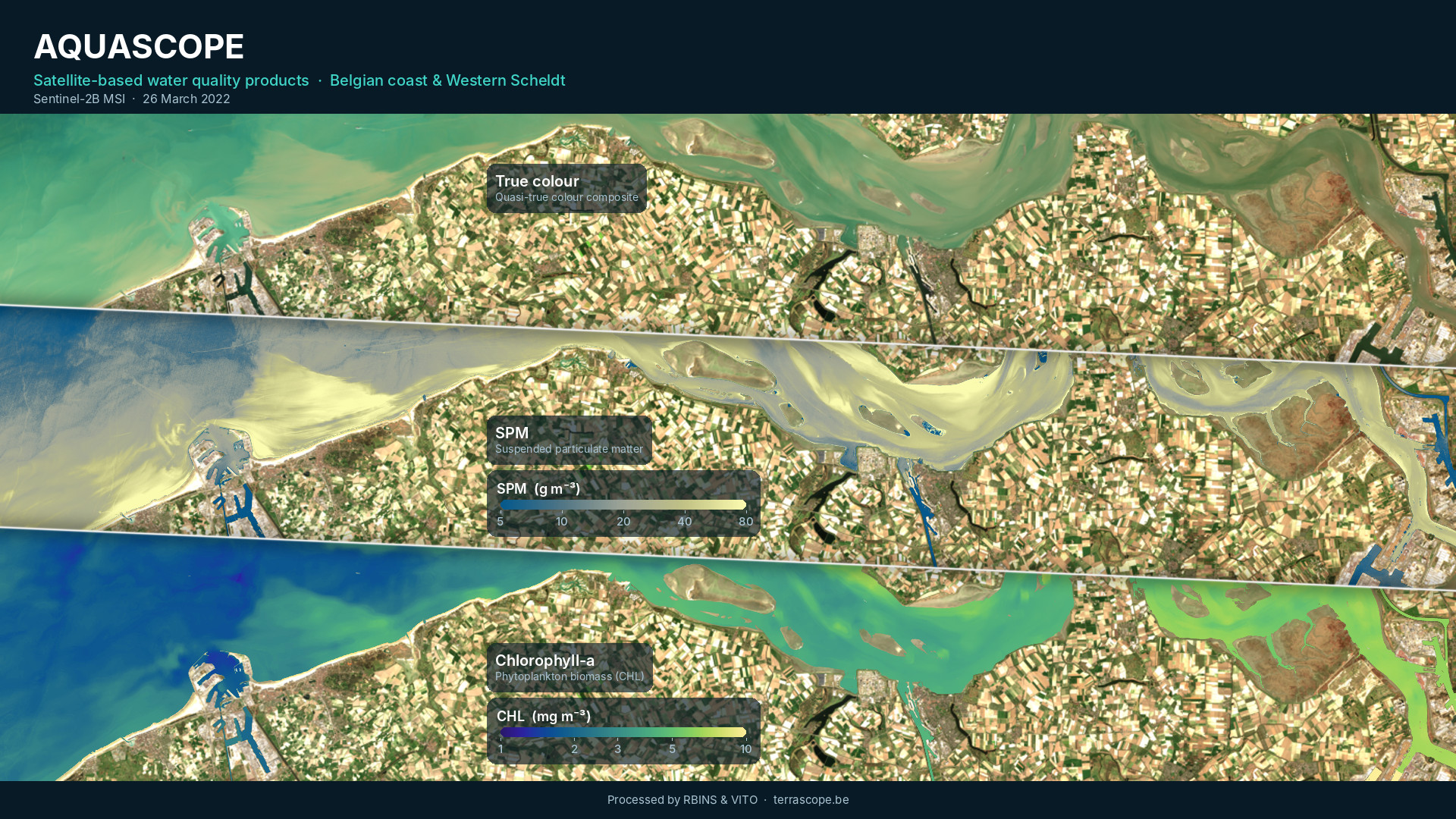
Terrascope is the Belgian Earth Observation platform providing easy access to satellite data, products and services. Traditionally focused on land and the atmosphere, Terrascope is now expanding its portfolio to the marine environment with new Aquascope water-quality data products for the Belgian North Sea.
Through Terrascope, users can explore and access these new aquatic products alongside other Earth observation data. In addition to viewing satellite data, Terrascope provides services to find and download data, analyse time series and process data to gain further insights into environmental changes and dynamics.
Explore the Belgian North Sea with Aquascope data products
Using data from a range of satellites (Sentinel-2, Sentinel-3 and Landsat 8 and 9), Aquascope provides data from 2015 to near real time, with recent observations processed within 24 hours. The available products cover a range of marine and coastal parameters, providing valuable information for monitoring environmental conditions and assessing the impacts of human activities at sea.
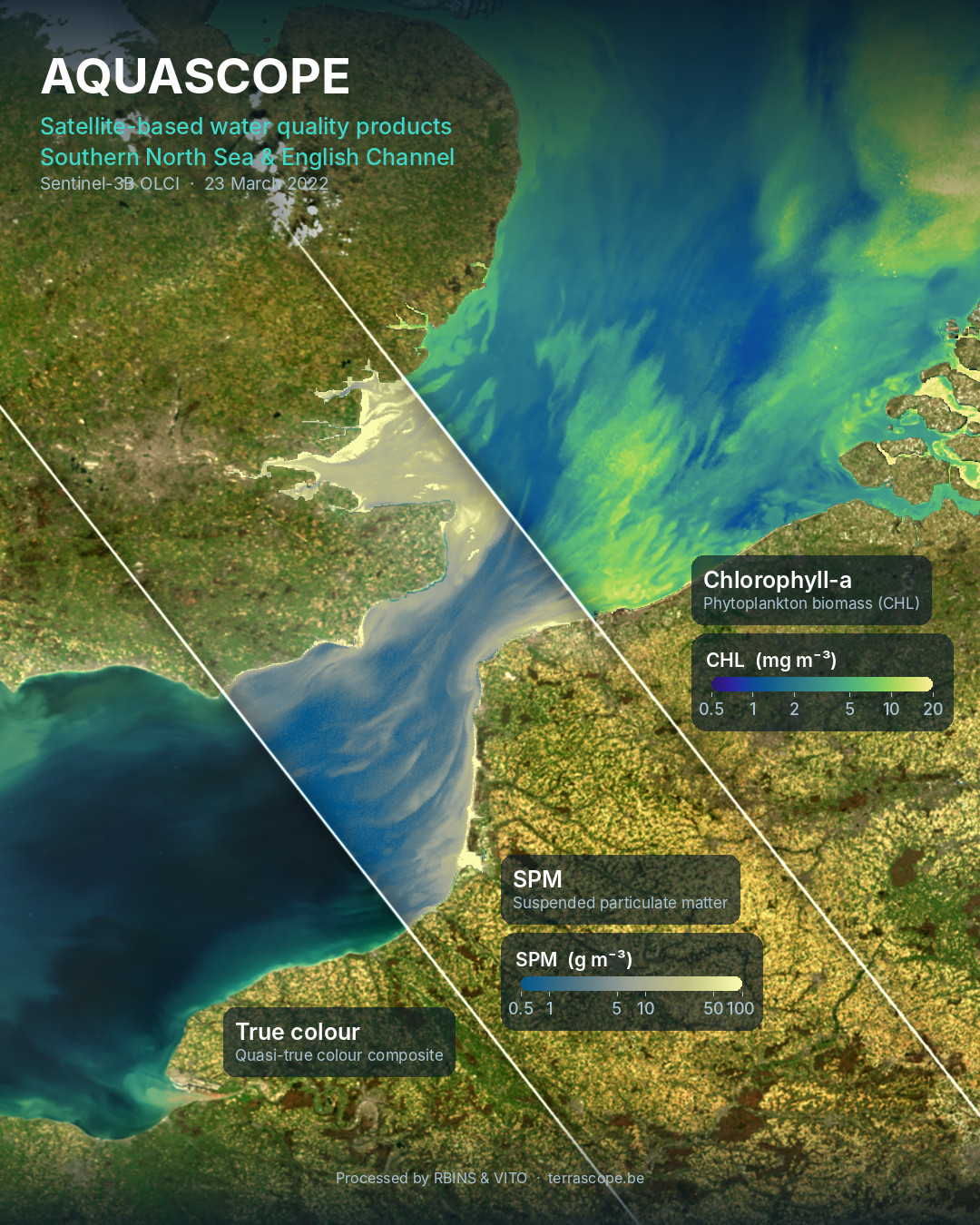
Quasi-true-colour (RGB) imagery and remote sensing reflectance (Rrs) allow users to visualise the sea surface as observed by satellites and explore its optical properties, helping to characterise coastal and marine environments.
Suspended particulate matter (SPM) and turbidity (TUR) products provide insights into sediment concentrations and water clarity. They can be used to track sediment transport, monitor dredging activities and coastal protection works, and assess the potential impacts of offshore infrastructure on the marine environment.
Chlorophyll-a (CHL) products provide information on phytoplankton biomass, supporting the assessment of water quality, the monitoring of phytoplankton dynamics and the study of eutrophication in coastal and marine waters.
Sea surface temperature (SST) products provide access to high-resolution temperature maps that combine thermal observations from Landsat and Sentinel-3. These data help users investigate the spatial and temporal variability of sea surface temperatures and monitor changes in the marine environment.
With spatial resolutions ranging from 10 metres for Sentinel-2 to 500 metres for Sentinel-3, the Aquascope products support both large-scale analysis and detailed investigation of coastal features such as sediment plumes. The processing algorithms are tailored to the turbid and nutrient-rich conditions of Belgian waters and validated using WATERHYPERNET radiometers, in-situ sampling stations and buoys in the Belgian North Sea.
More aquatic products coming soon
Over the coming months, Aquascope will expand its range of products to support coastal monitoring and early warning, providing users with improved tools to observe and assess changes in the marine environment.
Gap-filled, multi-resolution products for chlorophyll-a, suspended particulate matter and turbidity will combine data from Sentinel-2 and Sentinel-3 to generate daily, cloud-free maps.
Algal bloom detection and eutrophication assessment will help users identify and monitor algal blooms and assess the environmental conditions associated with eutrophication. These products will support marine environmental assessments and reporting obligations under the EU Marine Strategy Framework Directive (MSFD) and the OSPAR Convention.
Floating object detection will enable the identification of certain features at the sea surface, including foam lines that can form following Phaeocystis algal blooms and subsequently wash ashore. Monitoring these features can help improve our understanding of their occurrence and distribution along the coast.
Marine heatwave monitoring will focus on identifying periods of unusually warm seawater, which are becoming more frequent and intense as a result of climate change. By tracking these events and their evolution, Aquascope will help users better understand changes in sea surface temperatures and assess potential impacts on marine ecosystems.
Access the data
Aquascope data can be accessed through a range of Terrascope services, allowing users to explore, process, download and integrate the available products into their own workflows and applications.
Users can explore the products directly in the Terrascope viewer, which provides a convenient way to visualise satellite imagery and environmental data. For more advanced analyses, the Terrascope cloud services offer tools and computing resources to process the data online, without requiring users to download and manage large datasets locally.
Those who wish to access the underlying datasets can use the Terrascope STAC browser to discover and download products. Finally, the Web Map Tile Service (WMTS) allows users to integrate the data into GIS software and web applications, facilitating the visualisation and use of satellite-derived information alongside other geospatial datasets.
Together, these services make Aquascope data accessible to a broad range of users, from those who simply want to visualise coastal and marine conditions to researchers and professionals conducting more advanced analyses.
Aquascope is funded by the Belgian Science Policy Office (BELSPO) under the Terrascope II programme.