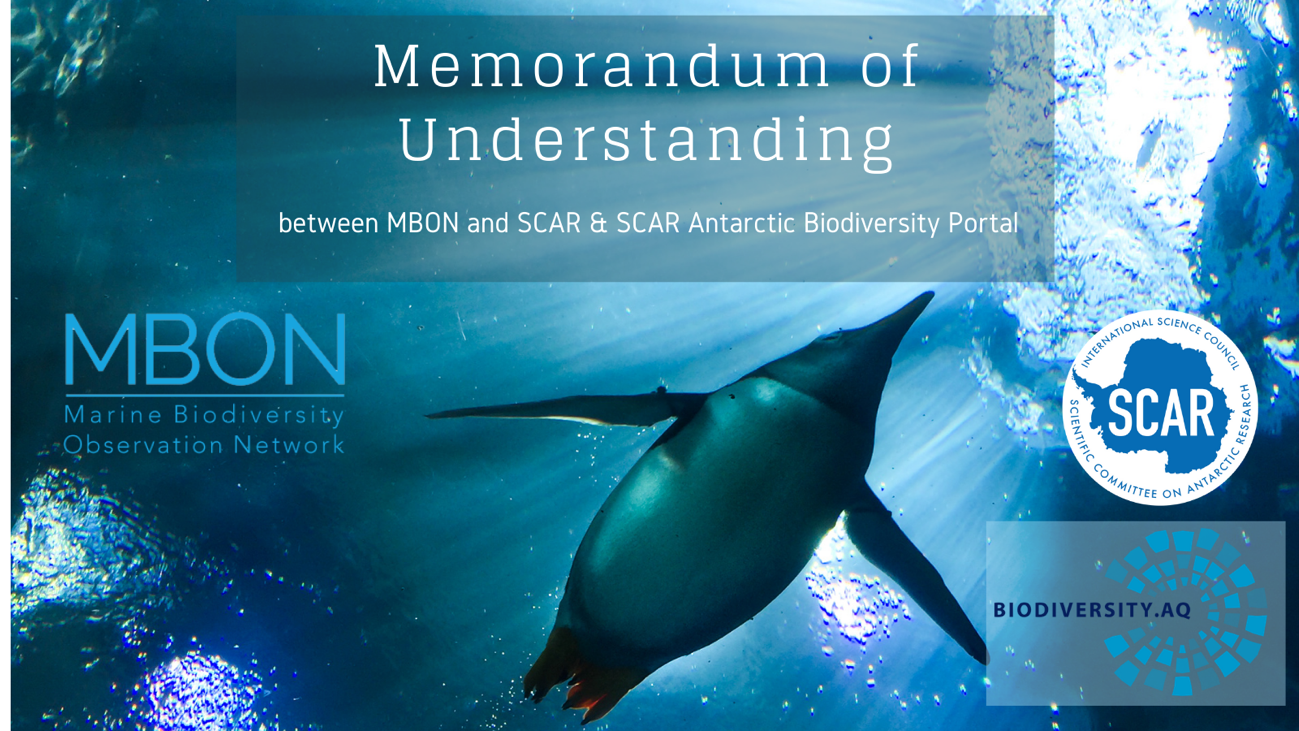
The Marine Biodiversity Observation Network (MBON), the Scientific Committee on Antarctic Research (SCAR), and the SCAR Antarctic Biodiversity Portal share a common vision on the building and coordination of a global ocean biodiversity observation system. The common goal is to systematically assess the state and trends in the ocean’s biodiversity, including biological resources and ecosystems, and how these will change in the future.
This observing system will provide the data, information and knowledge that people need to effectively conserve and sustainably use marine life, not only in the 4 traditional oceans but also the 5th Ocean recently recognized by National Geographic. The Southern Ocean, the ocean around the Antarctic continent, and all ocean water beyond Exclusive Economic Zones (EEZ) represent such a “commons” to humanity. Minding these waters from the surface to the abyss, and especially life in these areas, will inform progress towards safeguarding the environment and protecting the integrity of the ecosystem of the seas surrounding Antarctica as outline in the Convention for the Conservation of Antarctic Marine Living resources (CCAMLR), the global 2030 targets of the UN Sustainable Development Goals (including SDG 14) and the UN Ocean Decade, and the new 2050 targets and indicators of the Convention on Biological Diversity (CBD).
The agreement between MBON, SCAR, and the SCAR Antarctic Biodiversity Portal recognizes an ongoing cooperation to reinforce ocean biodiversity observing capacity, and to make use of the best available resources and expertise. The entities agree to collaborate respecting the principles of reciprocity, mutual benefit and results sharing, as well as to strengthen the exchange of ideas and integration with global marine data initiatives such as the Global Ocean Observation System (GOOS), the Ocean Biodiversity Information System (OBIS), the Ocean Best Practices System (OBPS), and others.
The actors:
The Marine Biodiversity Observation Network (MBON) is the key biodiversity pillar of the Group on Earth Observations Biodiversity Observation Network (GEO BON) for the marine realm. The MBON is a community of practice that facilitates the coordination of individual monitoring programs and existing networks focused on local, regional, and thematic aspects of marine biology and biodiversity, to improve standards and best practices in the collection, management, and publication of marine biodiversity data and the status and trends of ecosystems and their services.
The Scientific Committee on Antarctic Research (SCAR) is a thematic organisation of the International Science Council (ISC), and was created in 1958. SCAR is charged with initiating, developing and coordinating high quality international scientific research in the Antarctic region (including the Southern Ocean), and on the role of the Antarctic region in the Earth system. SCAR provides objective and independent scientific advice to the Antarctic Treaty System and other organizations such as the United Nations Framework Convention on Climate Change (UNFCCC) and the Intergovernmental Panel on Climate Change (IPCC) on issues of science and conservation affecting the management of Antarctica and the Southern Ocean and on the role of the Antarctic region in the Earth system.
The Antarctic Biodiversity Portal (biodiversity.aq) is an international effort of SCAR, that is hosted at the Royal Belgian Institute of Natural Sciences (RBINS). It finds it roots in the Census of Antarctic Marine Life and started in 2005. It seeks to increase our knowledge and understanding of Antarctic and Southern Ocean biodiversity. The SCAR Antarctic Biodiversity Portal is the regional thematic node of the Ocean Biodiversity Information System (OBIS), the Global Biodiversity Information Facility (GBIF) and works closely together with the Southern Ocean Observation System (SOOS). It provides support to publish Southern Ocean biodiversity data and to improve standards and best practices in the collection, management, and publication of marine biodiversity data.
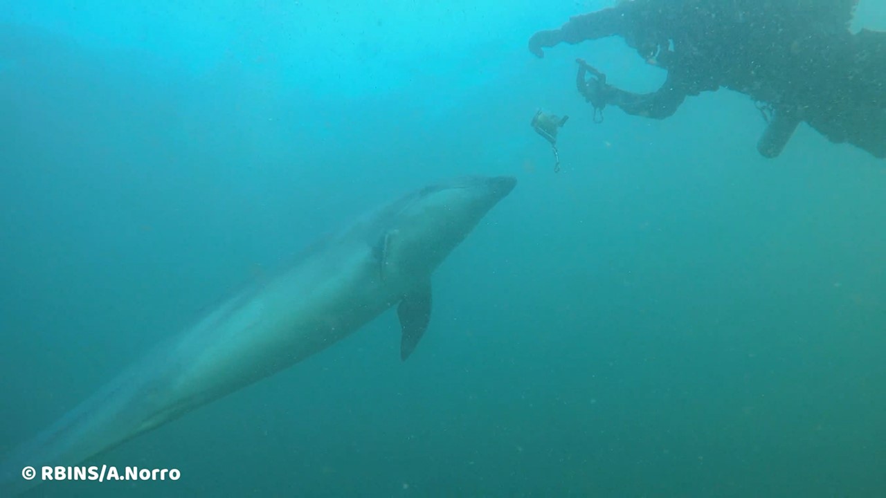
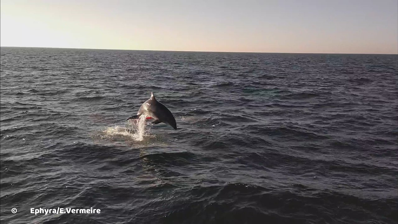
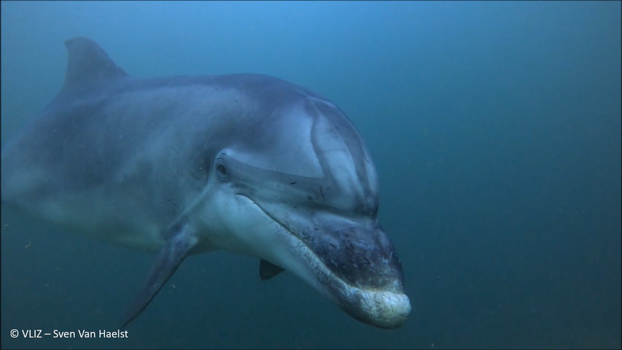
On 26 February, two Bottlenose dolphins accompanied scientists during an entire dive near the Westhinder measuring platform in the south-western part of the Belgian North Sea. Such social behaviour is known from solitary dolphins, including a Bottlenose dolphin that has been in this area for a long time, but is rather exceptional for a pair. The divers took advantage of the opportunity to shoot some beautiful images. Bottlenose dolphins seem to have become more common in Belgian marine waters in recent years. However, more recreation at sea, the growing ease with which images can be taken and the frequent sharing of information on social media also play a role in this perception.
On Friday 26 February 2021, scientific divers Alain Norro of the Royal Belgian Institute of Natural Sciences (RBINS), Sven Van Haelst of the Flanders Marine Institute (VLIZ) and Marc Van Espen (RBINS volunteer) received an underwater visit from two Bottlenose dolphins (Tursiops truncatus). The encounter took place near the Westhinder measuring platform in the southwestern part of the Belgian part of the North Sea. Sven also saw the dolphins three days earlier in this area, but then they kept their distance. Now, however, they sought out the divers from nearby, and Alain and Sven seized the opportunity to shoot some unique images. E. Vermeire was also able to add video material from the Ephyra.
Following this event, we list a few facts and uncertainties about Bottlenose dolphins in Belgian waters.
Bottlenose Dolphins in the North Sea and in Belgium
The Bottlenose dolphin may be considered part of the North Sea fauna, with established populations along the Normandy and Breton coasts (English Channel; approx. 400 specimens), and along the North Sea coast of England and especially Scotland (max. 150). There used to be a permanent population along the Belgian and Dutch coasts until half a century ago. The international agreement ASCOBANS (Agreement on the Conservation of Small Cetaceans of the Baltic, North East Atlantic, Irish and North Seas), in which the RBINS represents Belgium, estimates the total European Atlantic population (including the North Sea) of coastal Bottlenose dolphins at 2000 individuals. No reliable estimates are available for the Bottlenose dolphins living in oceanic Atlantic waters.
For a long time, the species seemed to be a rare occurrence in the Belgian waters. Since the turn of the century, often only a few sightings per year were recorded, and in some years none at all. Groups were even rarer, and the same can be said about long-term residents (e.g. August-November 2010 near Ostend, September 2014 near Knokke). From 2015 onwards, however, we see a change and Bottlenose dolphins are reported more frequently in Belgium. A dozen observations per year is no longer exceptional, and both groups and solitary specimens are found. The latter category includes a Bottlenose dolphin which has been regularly sighted for extended periods (months at a time) along the Belgian-French sea border since 2015, in the same area where the encounter of 26 February took place. More details on the occurrence of Bottlenose dolphins in Belgian waters can be consulted in the annual marine mammal reports of the RBINS (published since 2014).
Origin and Explanations for the Increasing Number of Observations
Animals which appear in our waters most probably originate from the Normano-Breton population or from the population of the east coast of Scotland. Cases of Bottlenose dolphins seen in Dutch waters could be linked to both populations by specific characteristics (e.g. scarring or damage to fins).
The population trend of the Bottlenose dolphin in the North Sea area and the Atlantic Ocean is not accurately known. It is therefore difficult to estimate the extent to which the recently increased number of Belgian reports is related to this. However, it is certain that different sightings sometimes refer to the same long-staying dolphin and therefore do not indicate an increase in numbers. Furthermore, marine biologists are now collecting data using a wider range of research techniques : dolphins and other marine mammals are no longer counted during expeditions with scientific vessels only, but are also documented by aerial counts and underwater acoustic monitoring. It is also noticeable that observations by non-scientists flow through better to the scientific databases (marinemammals.be, waarnemingen.be/ observations.be). Amongst others, the frequent sharing on social media leads to the fact that encounters with dolphins come to the attention of scientists more often. An increasing presence of recreational users at sea and the growing ease with which photos and film images can be taken may also play a role.
Reflections on Social Behaviour
Bottlenose dolphins, both solitary and in groups, are curious and playful animals. They like to approach ships and regularly swim along, often in the bow wave. Whether they also gain a biological advantage from this, we do not yet fully understand. However, true social behaviour towards humans is usually only seen in solitary animals. There are four stages of behaviour: in stage 1 the animal settles in a certain area but does not approach people ; in stage 2 it follows vessels, examines ropes and shows interest in people in the water (but keeps its distance) ; in stage 3 it accepts and seeks contact, and in stage 4 it may show aggressive, dominant or even sexual behaviour (although people usually interpret this as overly friendly behaviour).
The solitary Bottlenose dolphins that have been present in Belgian waters in recent years can be classified in stages 1 and 2, which means that at most they seek out and follow people. The latter also applies to the Bottlenose dolphin from the Westhinder area, which has previously followed divers during their descent to the seafloor or stayed with them during deco stops. The fact that the divers could count on the interest of two Bottlenose dolphins on 26 February can be called exceptional. Based on certain characteristics, it is suspected that one of the animals was the known long-dwelling animal that now apparently found company.
The occurrence of solitary Bottlenose dolphins in the southern part of the North Sea is possibly the result of the decimation of the historical populations. Animals that are expelled from a group, or leave the group, have a hard time finding other groups to join in the vicinity because those groups simply do not exist anymore. There are a number of theories as to the cause of animals becoming social towards humans. It is possible that it concerns animals that have been through a trauma, or that have never socially adapted within the group of their own kind. In this sense, the dolphins we call social (towards humans) can actually also be considered antisocial (towards conspecifics).
Context of the Scientific Diving Mission on 26 February
The scientific diving team was on site for a maintenance mission of the continuous underwater noise monitoring station on the Westhinder platform, carried out in the framework of the research project JOMOPANS (Joint Monitoring Programme for Ambient Noise in the North Sea, INTERREG). This platform serves primarily as a light beacon, and also plays an important role as a node in the monitoring network of the Flemish Maritime and Coastal Services Agency. For the occasion, the RBINS had rented the 19 m long charter vessel Ephyra, with which the team of three divers could observe the applicable COVID-19 rules for social distance.
These and other joint scientific diving missions are organised within the framework of cooperation between various institutes, universities and government departments in the Scientific Diving Working Group, which is coordinated in Belgium within the Federal Science Policy Office (BELSPO).
Social Distancing from Dolphins
It is not impossible that bottlenose dolphins may be encountered in Belgian waters this summer. We would like to draw your attention to the fact that in such cases it is best to keep a distance from the animals, and let them approach the vessel themselves, rather than actively seeking them out. In the North Sea, too, there have been recent cases of collisions between fast boats and bottlenose dolphins, often with fatal consequences for the animals involved.
From July 1st, 2021 to September 30th, 2021 included, the Marine Environment Service from FPS Public Health is organizing two public consultations on environmental policy in the North Sea. One revolves around Natura 2000 and the other around the Marine Strategy.
Conservation objectives and Natura 2000 management in the Belgian part of the North Sea:
The Habitats and Birds Directive require that EU Member States establish protected areas (Natura 2000 areas) for the protection of habitats and species. In the Belgian part of the North Sea, 37% of its surface has so far been designated as a Natura 2000 area. The protected habitats in these areas are sandbanks, gravel beds and tubeworm beds. The harbor porpoise, harbor seal and grey seal are the protected species.
In order to get to a good management of the Natura 2000 zones, the European Commission requests that goals are fixed for conservation and development of management plans. These indicate the actions that are pursued and undertaken in the Belgian part of the North Sea to restore or maintain a favorable conservation status for the protected habitats and species.
Program of measures for the Belgian marine waters, in the framework of the Marine Strategy.
The Marine Strategy Framework Directive (MSFD) requires each European Member State to develop a marine strategy for the protection, conservation and restoration of the marine environment. The aim of this directive is to achieve a good environmental status of the North Sea and a sustainable use of marine waters.
The program of measures for Belgian marine waters includes a variety of measures on different environmental aspects such as biodiversity, soil integrity, underwater noises and water quality. These include awareness campaigns, monitoring and control, and environmental restoration measures.
DG Environment coordinates the implementation of the MSFD in Belgium. RBINS scientific service MUMM is responsible for coordinating the monitoring and evaluating the situation. This process is carried out in collaboration with various partners.
Consistency between Natura 2000 and the marine Strategy
Natura 2000 and the Marine Strategy are closely linked. Good environmental status and sustainable use of the marine environment are essential to develop Natura 2000 areas. The protection of habitats and species in these areas is likewise important for achieving the biodiversity objectives of the Marine Strategy.
In addition, a number of measures are needed to both achieve good environmental status and protect habitats and species in Natura 2000 areas. Such measures include seabed protection, gravel bed restoration and a methodology for assessing cumulative effects.
That is why the new program of measures fulfills not only the objectives of the Marine Strategy, but also the conservation objectives of the Habitats and Birds Directives. Conversely, the conservation objectives have been aligned with the updated environmental goals of the 2018 Marine Strategy Framework Directive, and the existing management plans have been revised based on the new program of measures.
These public consultations fall under the Aarhus Convention, which gives you the right to be involved in environmental decision-making.
More information:
You can find all the documents and more information on how to submit your comments at www.consult-environnement.be:
Public consultation on the conservation objectives and management plans for Natura 2000 in the Belgian part of the North Sea (FR / NL)
Public consultation on the program of measures for Belgian marine waters, in the framework of the Marine Strategy (FR / NL)
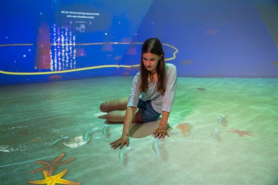
As of this summer, Mechelen is the place to be for an extraordinary day out by the sea. As of the beginning of July, Technopolis will be opening Sea Force, a brand-new exhibition where one moment you imagine yourself to be on the coast, the next moment at the bottom of the sea and not much later in the port of the future. And all that thanks to fine examples of technology. Sea Force is the first exhibition in Technopolis where, in an immersive digital environment, you are truly immersed in a future where science and technology are central. The Royal Belgian Institute of Natural Sciences is a partner in the new expo, providing expertise on monitoring and reducing the ecological impact of offshore wind farms and stimulating underwater nature in such projects.
Sea Force, a brand new exhibition in Technopolis where you can dive into the sea and the port of tomorrow, will be open from the beginning of July 2021. And you can take that quite literally. Via projections and interactive floors and walls, it seems as if you are completely submerging and are walking on the bottom of the sea where fish swim around your feet and follow you everywhere. If you look further, you will see floating solar panels, underwater farms and bubble curtains that protect porpoises from underwater noise. In short, you have never seen the sea and the harbour like this before.
This is because Technopolis is using an immersive digital space for the first time to immerse visitors in a sustainable future where science and technology are central. Sea Force is not only a visual and technological tour de force. In terms of content, the exhibition tells a particularly strong story of the future in which science and innovation make the most of the power of the sea while protecting it at the same time. Important themes such as shipping, renewable energy and food are addressed.
These themes were incorporated into fun assignments. While playing, you get answers to questions such as “Will we soon be growing our food in underwater farms?”, “Will there be artificial energy islands off Blankenberge or Ostend?” and “What is the power and importance of the sea?”. In addition, you can design your own wind turbine and bring the power on land, discover fish species with an underwater drone, investigate ways of generating and storing green energy…. A gigantic interactive port table will take you to the port (or should we say energy hub) of the future and you will discover how/if we will soon be saying goodbye to ships driven by fossil fuels.
Sea Force is an exhibition that will fascinate young and old. Young people from 12 years of age and adults alike can immerse themselves in the numerous themes that are presented and can be inspired to work (later) in the marine and maritime sector. Younger children will enjoy the visual spectacle and the technology of the immersive digital space, which allows fish and other graphic elements to follow their movements. Entry to Sea Force is included in the entrance fee to Technopolis.
UN Sustainable Development Goals
Technopolis proudly calls itself SDG (Sustainable Development Goals) Voice and uses Sea Force to inform visitors on a series of goals set by the United Nations to make the world a better place by 2030. Via Sea Force, Technopolis and its partners (goal 17 – involve stakeholders) show how important reliable and sustainable energy is (goal 7), why action against climate change is really necessary (goal 13) and how the sea can be used in a sustainable way with all due respect for life in the water (goal 14).
Stephane Berghmans, CEO Technopolis: “Sea Force is the first expo in Technopolis where you can walk into the future and see and experience with your own eyes how we can make that future more sustainable through science and innovation. This would not have been possible without the financial and substantive contribution of our partners, all of them drivers of innovation in Belgium. We hope that together we will inspire many children and young people to later contribute to our so-called “blue economy”. Tell us, which professions appeal more to the imagination than marine biologist, wind farm designer or seaweed farmer? Whatever they choose later, our message is clear: the best mates for our future are not all on shore. Everyone can and may contribute to a better world.
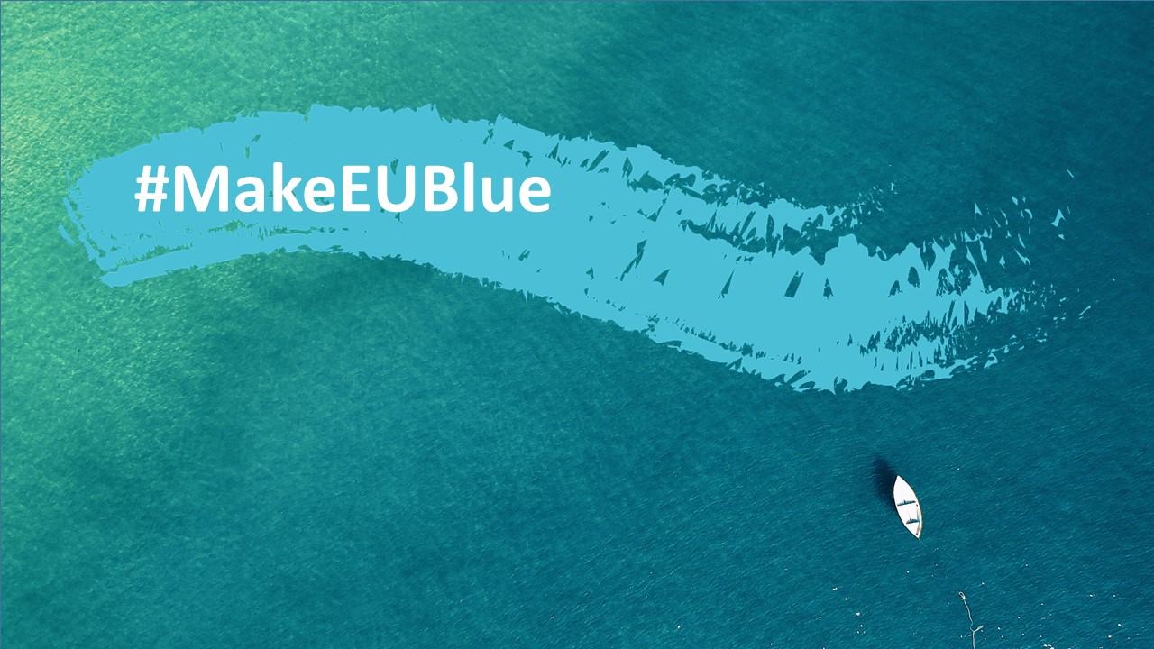
On 20 May 2021, the EU4Ocean Coalition launched the #MakeEUBlue campaign.
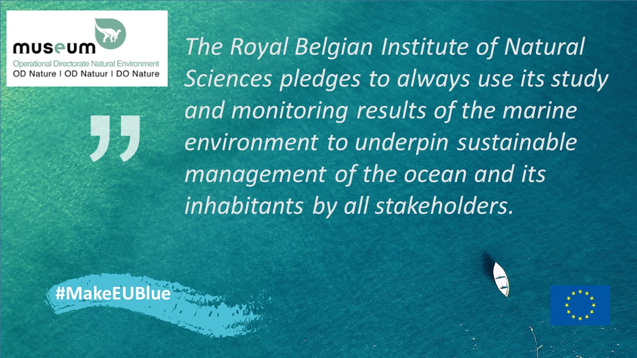
The Royal Belgian Institute of Natural Sciences (RBINS) has joined the EU4Ocean Coalition in 2020, as a founding member of the EU4Ocean Platform. As ocean research, monitoring and communication are important activities of RBINS, this was a logical step. In the EU4Ocean Platform, RBINS engages and collaborates with a diverse set of organisations and initiatives and mobilises its efforts in the field of ocean literacy.
The Make Europe Blue Campaign
No matter where you live, what you do or the size of your contribution, we can all act together for a healthy ocean in Europe and beyond.
Discover the Ocean
The ocean gives us life. Half the oxygen we breathe is generated from the ocean. The ocean regulates our climate, provides us with food, jobs and wellbeing. However, the ocean is in crisis from a multitude of threats including climate change, overfishing and pollution. No single action or entity can reverse this trend. Changing course requires us to work together, changing mind-sets and policies, as governments, business and individuals, on multiple fronts.
“Every action – even the smallest one – brings change to our ocean”
With a commitment from each and every one of us, we can protect the ocean and make Europe blue.
The Make Europe Blue campaign calls on us: citizens, businesses, organisations, authorities, celebrities, educators to make a pledge to help the ocean. Your pledge is a personal promise or action that will keep our ocean healthy.
As a citizen, you can avoid single-use plastics, only eat sustainably caught seafood, or support a charity/NGO working for a healthy ocean. As business, you can ban single-use plastics in the offices, or commit to ocean-friendly sourcing, such as avoiding products from deep-sea mining. As an educator, you can inspire pupils by implementing ocean-related projects. You choose!
Get inspired by exciting facts about the state of the ocean
Make an original pledge for the wellbeing of the ocean
Share it with others using the #MakeEUBlue hashtag
Any type of pledge that serves our ocean will be accepted, so use your imagination, get creative and – together – we will make this happen.
Inspire others
The more we are, the stronger we become. Share your pledge using the #MakeEUBlue hashtag. You can inspire those around you, and send a clear and simple message: We are acting for the ocean, are you? Make EU Blue!
If you are an individual, tag friends, families or peer groups. Challenging others to make a pledge can inspire them to take action
If you are an organisation or institution, communicate the campaign within your network, and amplify the campaign at events you are joining or hosting
If you are a celebrity, engage your followers to bring them on board!
If you are an educator, inspire the young generation
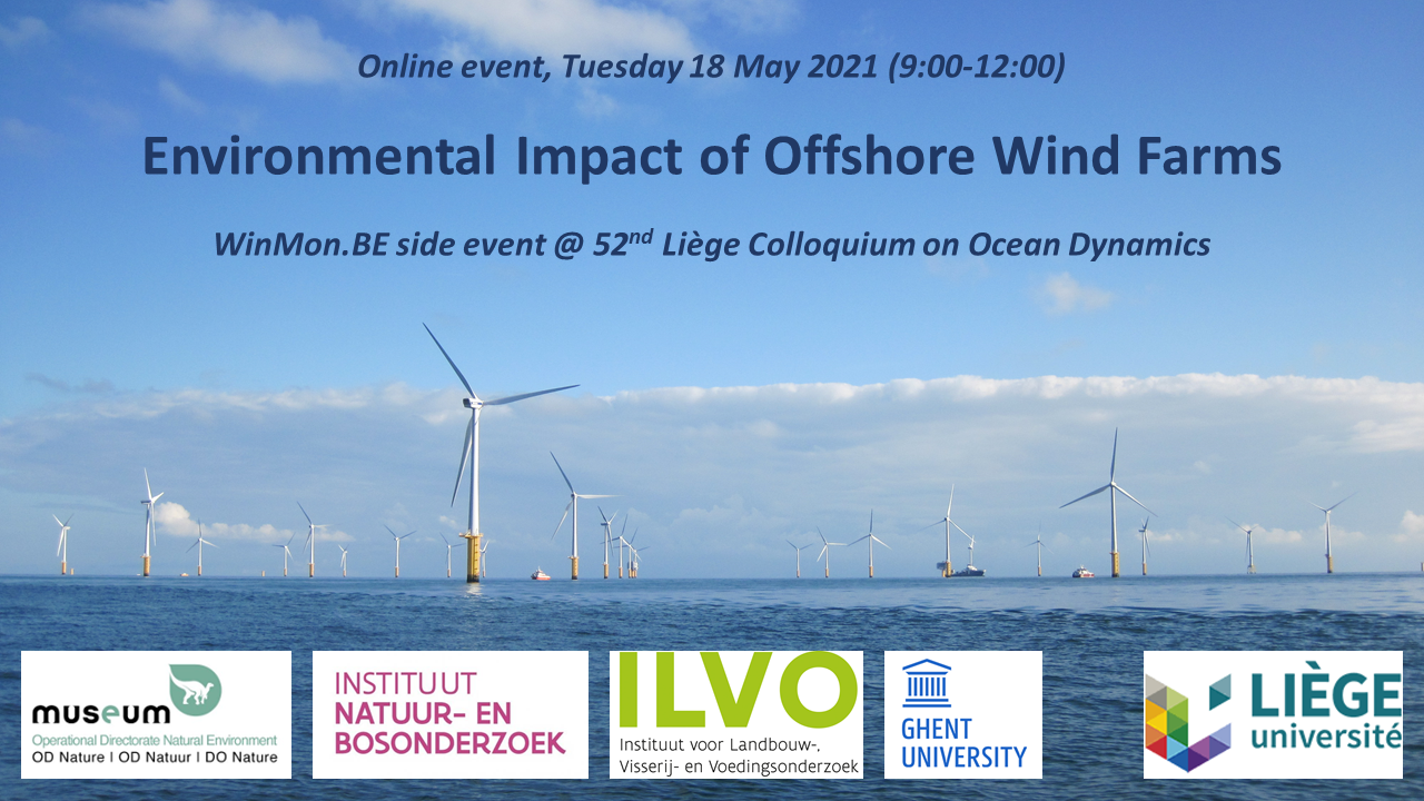
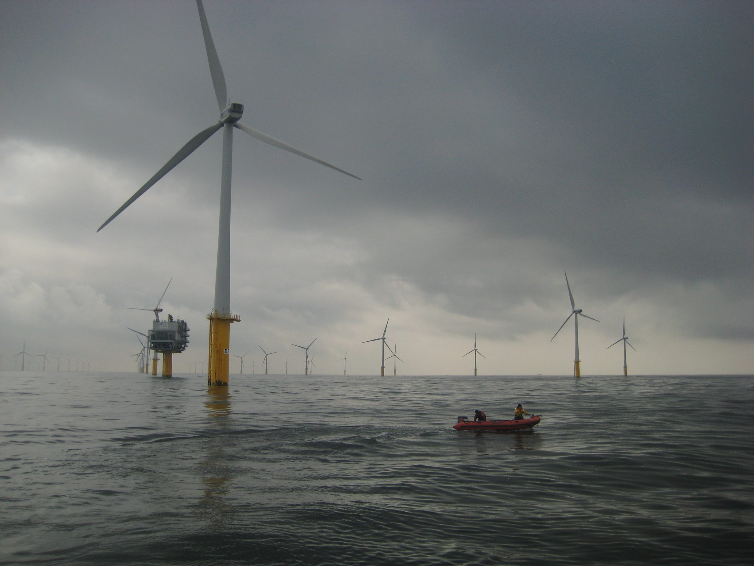
WinMon.BE, the Belgian offshore wind farm (OWF) environmental monitoring programme, started in 2008 and is coordinated by the Royal Belgian Institute of Natural Sciences (RBINS). RBINS and the WinMon.BE partners INBO (Research Institute for Nature and Forest), ILVO (Flanders Research Institute for Agriculture, Fisheries and Food) and Marbiol (Marine Biology Research Group at Ghent University), assess the extent of the anticipated impacts of offshore wind farms onto the marine ecosystem and aim at revealing the processes behind these impacts.
On May 18th, from 9:00 to 12:00, the WinMon.BE consortium is organizing an event to share and discuss results from the monitoring programme. This symposium is hosted as a side event of the 52nd Liège Colloquium on Ocean Dynamics (Towards an understanding and assessment of human impact on coastal marine environments, 17th – 21st of May 2021; http://labos.ulg.ac.be/gher/home/colloquium/colloquium-2021/), and will be conducted in English.
Lessons learned from the WinMon.BE programme will be presented, followed by a panel discussion. During the discussion, special attention will be paid to the science-management-policy nexus as how to best achieve an environment-friendly implementation and an ecosystem-based management of offshore renewables. This session is free of charge and targeted at scientists, industry, managers and policy makers.
Programme:
9:00 – 9:05: Welcome (Vincent Van Quickenborne – Minister of North Sea)
9:15 – 9:40: Keynote: ‘Using a decade of WinMon.BE results to plan for the future’ (Steven Degraer – RBINS)
9:40 – 9:50: ‘The importance of long-term monitoring for environmental impact assessment: epifaunal communities in Belgian OWFs’ (Mirta Zupan, Francis Kerckhof, Bob Rumes & Steven Degraer – RBINS)
9:50 – 10:00: ‘Evolution of piling activities because of increasing insights in associated effects’ (Bob Rumes, Elisabeth Debusschere, Jan Haelters & Alain Norro – RBINS)
10:00 – 10:10: ‘Adaptive survey strategies to assess the impact of OWFs on seabirds’ (Nicolas Vanermen, Wouter Courtens, Marc Van de Walle, Hilbran Verstraete & Eric Stienen – INBO)
10:10 – 10:25: Q&A
10:25 – 10:35: Break
10:35 – 10:45: ‘Functioning of the benthic ecosystem in OWFs: food webs and biogeochemical cycling’ (Ulrike Braeckman, Nene Lefaible, Tom Moens, Jan Vanaverbeke & Steven Degraer – UGent)
10:45 – 10:55: ‘Accounting for opportunities and threats of OWFs for nature conservation’ (Annelies De Backer, Jolien Buyse & Kris Hostens – ILVO)
10:55 – 11:10: Q&A
11:10 – 11:55: Panel Discussion: ‘WinMon.BE: ready for accommodating the future of OWFs?’ Panelists:Ghada El Serafy (Deltares), Annemie Vermeylen (BelgianOffshorePlatform), JesseVerhalle(FPS Health, Food Chain Safety and Environment), Brigitte Lauwaert (RBINS/MUMM)&Steven Degraer (RBINS/MARECO)
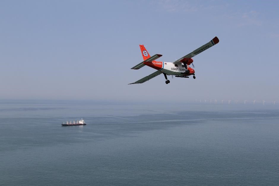
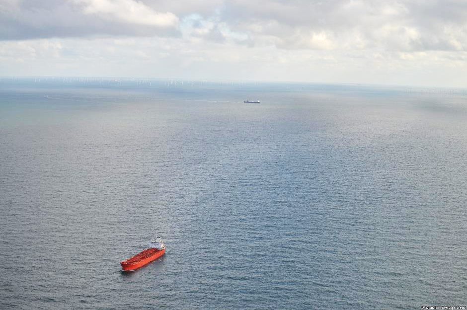
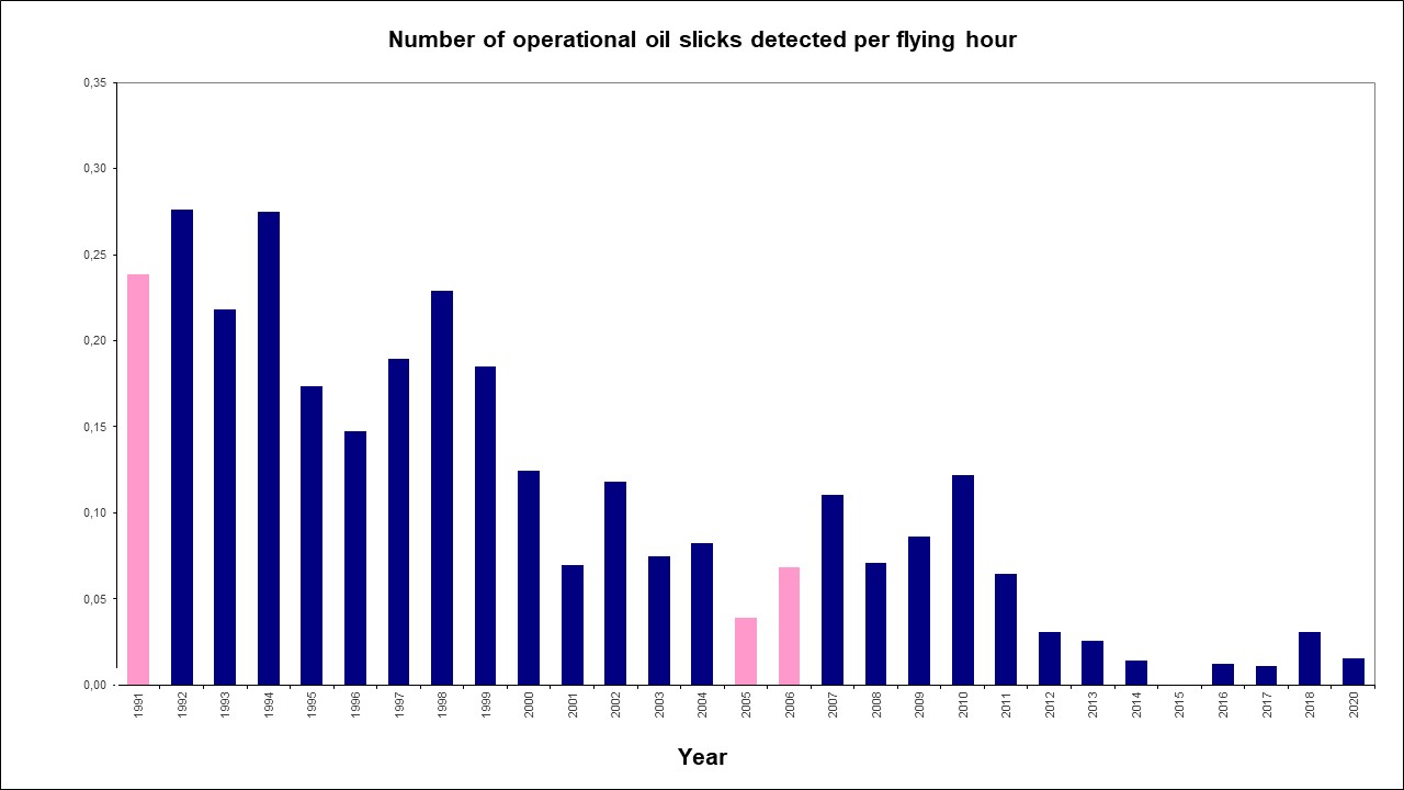
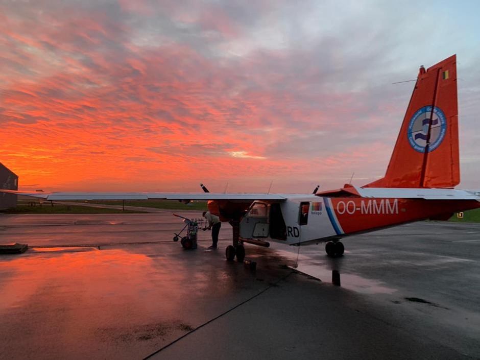
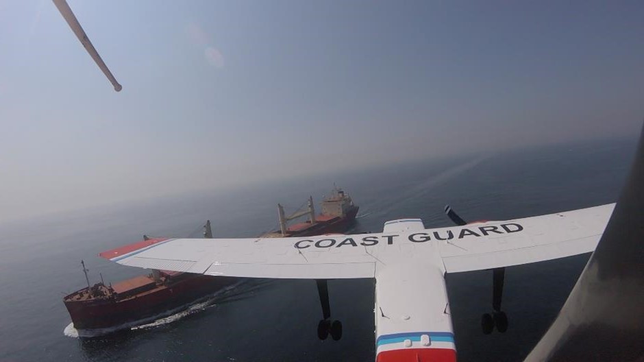
In 2020, the Royal Belgian Institute of Natural Sciences (RBINS) performed a total of 158 flight hours over the North Sea in the framework of the national programme of aerial surveys. Ten cases of operational discharges by ships have been observed, and one case of accidental pollution that resulted from a collision between two tankers. Additionally, suspicious sulphur values have been measured in the smoke plumes of 10 vessels. Since 2020, the sniffer sensor is able to measure nitrogen emissions as well. With this capacity expansion, Belgium keeps on playing an international pioneering rolein the field of ship emission monitoring. Notwithstanding the COVID-19 pandemic, the aircraft also successfully participated in an internationally coordinated surveillance mission of the oil and gas installations in the central part of the North Sea. Furthermore, the annual marine mammal counts were also carried out successfully.
A total of 158 flight hours have been performed in the framework of the national North Sea aerial survey programme in 2020. This programme is organised by the Scientific Service MUMM (Management Unit of the Mathematical Model of the North Sea) of the Royal Belgian Institute of Natural Sciences, in collaboration with the Ministry of Defence. Due to the COVID-19 pandemic, less flight hours could be performed than initially planned. However, due to the elaboration and application of an extensive Covid-19 switching plan, a considerable part of the anticipated hours (approximately 75%) was performed despite the exceptional and difficult circumstances.
Most of the flight hours were for national flights (136 hours):
92 hours for pollution control: 56 hours for the detection of discharges of oil and other harmful substances (MARPOL Annex I, II and V) and 36 hours for the monitoring of sulphur emissions from ships (MARPOL Annex VI / SECA – Sulphur Emission Control Area enforcement;
27 hours for fishery control, on behalf of and in cooperation with the Flemish Fishery Inspection Services;
9 hours in response to a specific alerts: a collision with pollution, a considerable accidental oil pollution in the western Scheldt, an alert for large amounts of brown substances in the water (after verification it turned out to be algae) and a search for a whale in Belgian waters.
8 hours for marine mammal monitoring.
A smaller part (22 hours) has been spent on the international level: the Tour d’horizon-mission for aerial surveillance of offshore oil and gas installations in the North Sea, an international mission framed in the BONN Agreement.
Accidental Pollution
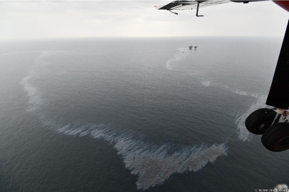
On 12 and 13 May 2020, a small accidental spill of a liquid noxious substance (LNS) other than oil was observed after a collision between the vessels ISOLDE and NAVIGATOR CERES. The pollution originated from the slightly damaged ISOLDE. The traces, which had an oily appearance, could be observed in the vicinity of ISOLDE at the sea surface for 2 days during 4 consecutive flights. The pollution was not a consequence of a loss of cargo but due to an accidental loss of Bioneptan, a bio-oil used to lubricate the screw drive. Given the nature and the limited discharged volume (<100L), this accidental pollution did not pose a major threat to the marine environment.
Besides the accidental spill, 10 cases of operational discharges from ships have been observed throughout the year:
2 minor oil spills (MARPOL Annex I), that could not be linked to a polluter.
8 spills of liquid harmful substances other than oil (MARPOL Annex II). In one of these cases a link could be made with a ship; a port state control was requested in the next port of call. This made clear that it consisted of a permitted discharge of sunflower seed-oil (MARPOL Annex II).
In addition to aerial surveillance with the Coast Guard aircraft, MUMM also regularly receives alerts from satellite detections of possible marine pollutions. This Clean Sea Net (CSN) satellite surveillance service is provided by the European Maritime Safety Agency (EMSA). In 2020, the aircraft carried out 5 verification flights in response to a CSN satellite detection alarm of a possible contamination in the Belgian surveillance area. In one case, a contamination was effectively confirmed by the aircraft, involving a harmful liquid substance other than oil. During the other 4 verifications, no detections of pollutions could be made (anymore). Feedback was provided to EMSA for each verification.
The numbers show that the number of oil spills has been greatly reduced in the last decade (graph 1), while the number of spills of other harmful substances remains a common problem, that even appears to be on the rise (graph 2). It should be noted that it often concerns discharges that comply with international discharge standards, as contained in Annex II of the MARPOL Convention. From 2021, stricter MARPOL Annex II discharge standards are in force for so-called “persistent floaters” such as paraffin-like substances. The impact of these stricter discharge standards at sea will be monitored in the coming years.
Oil Pollution in Belgian Ports and the Western Scheldt
During transit flights from the airport of Antwerp (the home-base of the Coast Guard aircraft) to the North Sea, one oil spill has been observed in the port of Antwerp and one accidental oil spill in the western Scheldt. In the latter case, sludge oil was pumped out by a vessel during debalasting operations as a result of corrosion between the ballast and sludge tanks. Both observations were immediately reported to the competent authorities to ensure follow-up.
Monitoring of Sulphur Emissions from Ships at Sea
Due to application of a ‘sniffer’-sensor in the aircraft our country is known as a pioneer in the international combat against air pollution from ships at sea. The sensor makes it possible to measure pollutants in the emissions of ships on site.
Sulphur measurements have been on the program since 2016. In order to monitor compliance with the stringent fuel sulphur content limits for ships sailing in the North Sea SECA (Sulphur Emission Control Area), 25 sniffer fights (36 hours) were conducted. Of the 394 vessels of which the sulphur exhaust was measured at sea, 10 showed a suspiciously high sulphur value. These cases were systematically reported to the competent maritime inspection services for a further follow-up in port.
Thanks to the successful integration of a NOx sensor, the aircraft can now also measure the concentration of nitrogen compounds (NOx) in the smoke plumes of ships. This new sensor was extensively tested in 2020, where it was also possible to determine the nitrogen emissions of the 394 monitored ships. The associated monitoring and reporting procedures were also worked out, which means that Belgium is the first country ready to start monitoring and enforcing the strict restrictions that will apply in the North Sea from 1 January 2021 regarding nitrogen emissions from ships. Therefore, RBINS continues to play a key role on the international level in the field of MARPOL Annex VI. During the 2020 tests, it was found that the majority of the inspected ships already complied with the new rules, although some were documented with nitrogen concentrations in their emissions that were more than double of the 2021 limit values.
The annual TdH-mission for the surveillance of offshore platforms in the central part of the North Sea (in Dutch, German, Danish, Norwegian and British waters), performed in the framework of the Bonn Agreement, was conducted in September 2020. Due to the COVID-19 pandemic, the team was forced to change the classic flight route (with stops in several North Sea countries) and to operate exclusively from the United Kingdom. The Belgian surveillance aircraft detected 24 pollutions, of which 21 oil could be directly linked to offshore installations. The 3 remaining detections – 2 oil spills and 1 detection of another harmful substance – were made without a vessel or platform in the vicinity. All detections were systematically reported for further follow-up to the competent Coastal State, in accordance with agreed international procedures.
In 2020, RBINS conducted two surveys in Belgian waters to determine the distribution and density of harbour porpoises. Such surveys are also carried out in other North Sea countries in a standardized manner, in order to obtain long-term data that yield a bigger picture of the population dynamics for the entire southern and central North Sea. Due to COVID-19 restrictions, the seasonal surveys could only be carried out at the end of June and the beginning of September. Although these months are not the peak months for the presence of harbour porpoises in our waters, considerable numbers were still spotted during these campaigns.
During the survey in June 34 harbour porpoises were spotted, whereas in the beginning of September 37 individuals were recorded. The resulting estimates of average density in the Belgian part of the North Sea were 0,56 and 0,55 harbour porpoises per km², corresponding to about 1900 animals in Belgian waters. Besides harbour porpoises, other marine mammals were spotted too during the campaigns: in June 3 seals were recorded, in September this number was 13, the highest number recorded since the start of the surveys. Of those 13 seals, 3 were identified as adult grey seals. In September one bottlenose dolphin was spotted in the north-western part of the Belgian waters.
So far in 2021, 22 dead seals have washed ashore along the Belgian coast. Half of them, mostly young grey seals, showed characteristic neck and head injuries. There was talk of decapitations and this caused quite a stir. A forensic analysis by the Royal Belgian Institute of Natural Sciences and the Faculty of Veterinary Medicine of the University of Liège concludes that these seals were unintentional by-catch from professional fishing with trammel or gill nets. The sudden large number of dead animals can be explained by the high number of young grey seals currently present on our coast, following the large population growth in the south-east of England.
Seals, both harbour seals and grey seals, are no longer endangered species in the southern part of the North Sea: populations are growing and, in the case of grey seals, they are larger than at any time in the history of the North Sea. This also means that seals are increasingly present in our waters and on our beaches.
From December 2020 until spring 2021, there was an invasion of very young grey seals: young animals were spotted daily on our coast. Undoubtedly, the vast majority of these animals came from colonies in the south-east of the United Kingdom, where record numbers of grey seals were born in November and December 2020. For example, the largest colony, that at Blakeney Point (Norfolk, England), gave birth to around 4,000 grey seals in the winter of 2020-2021, compared to 3,399 in 2019-2020 and just 25 in 2001.
Dead Seals in 2021
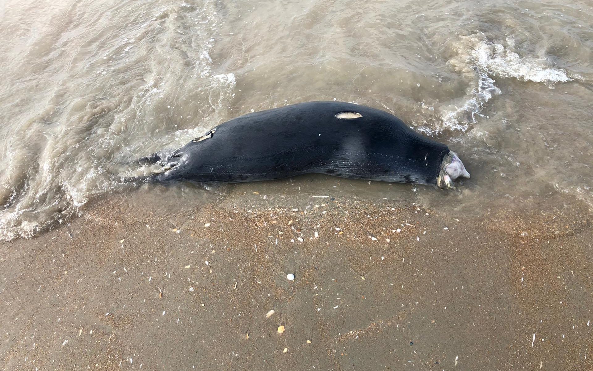
Together with the high number of grey seal sightings, a striking number of seals have washed ashore dead in recent weeks, sometimes several a day: 22 this year. Half of these animals, most of them very young grey seals born last winter, showed a characteristic injury on the neck and head. Most of them washed ashore between Ostend and De Panne. In collaboration with a veterinarian and a forensic pathologist, some of the animals showing typical injuries were examined.
The injuries on the young grey seals are almost identical. The following observations and conclusions were made:
The head is usually not gone, but badly damaged; the skull is often still there, with fractures and exposed bone: the overlying skin and tissue are gone;
The skin is torn off from the head in a circular manner from the neck down (scalping);
The injuries are post-mortem (no bruising in the exposed fatty tissue);
The injury is more of a laceration, in layers; no hairs have been cut, which rules out incision by a sharp knife;
The injuries were caused by mechanical action: not by knives but by a rotating device.
Probable Cause of Injuries
Scavengers have the easiest access to a dead seal through the head. Gulls will quickly peck out the eyes and from there remove fat and meat via the head. Especially decomposing animals often first cause major damage to the head. The injuries to the dead seals in the spring of 2021, however, clearly have an identical background, which is not to be sought in scavenging but in a human factor.
The conclusions of the study are as follows:
The seals have been caught incidentally in professional fishing with warren nets or gill nets, they get stuck in the net on the bottom and drown.
The animals are trapped with their heads in the net; the net retrieval system (system with a large pulley/”drum”), together with the fine nylon thread, causes a circular incision, not typical of a knife cut, and leads to the turning of the seals’ heads through the system with crushing of the lower and upper jaw and scalping of the skull.
After the catch, the fishermen throw the animals overboard.
The following additional remarks are important:
The number of seals washed ashore is only a fraction of the total number of seals caught incidentally.
Animals that are very fresh when washed up have been caught incidentally close to shore. Animals in a state of decomposition may have been caught incidentally both close to and further from shore.
It is highly unlikely that fishermen deliberately kill seals.
A probable explanation for the sudden large number of dead animals is the high number of young grey seals currently present on our coast, something which used to be much less the case.
Possible explanations for why only relatively small seals show such injuries are that (1) larger seals will fall out of the net before coming into contact with the drum due to their weight when hauling it up and (2) many more small seals were present during this period.
The incidental catch of seals is well known, and is dealt with in the context of the OSPAR Convention and implementation of European directives. The incidental catch cannot be considered a violation. What is necessary, but hardly ever happens, is the reporting of by-catch to the authorities if the by-catch is by a Belgian fishing vessel (obligatory according to the Royal Decree of 21 December 2001).
The mortality of seals through incidental catch is not of a level that would endanger seal populations in our waters. However, bycatch is potentially problematic in the context of our obligations under the European Habitat Directive and the Marine Strategy Framework Directive.
Conclusion
The renewed presence of seals leads to conflicts: seals are increasingly caught incidentally during fishing activities, both recreational and professional.
Professional fishing with gill and trammel nets is suspected to be the cause of the typical injuries in at least 11 seals washed ashore in 2021. These are mostly young grey seals born in the winter of 2020-2021 which, after weaning, start to roam the southern North Sea. Passive fishery with gill and trammel nets often involves setting miles of nets from a vessel. The nets are left in place for up to 24 hours. In the southern part of the North Sea, this type of fishing is especially intensive in February to May, the season when sole migrates. It is popular in the north of France, but occurs less in our coastal waters. French fishermen do not have access to our 12-mile zone. The same phenomenon of high numbers of stranded young grey seals is observed in the North of France.
Incidental catches of marine mammals should be considered as one of the negative effects that fishing has on the ecosystem. Because seals are popular, such mortalities often lead to public outcry. It should also be remembered that any form of fishing has an impact on the ecosystem, and passive fisheries, which are dangerous for marine mammals, have environmental advantages over beam trawling in terms of CO2 emissions, selectivity and bottom disturbance.
The Royal Belgian Institute of Natural Sciences (RBINS) has, together with a number of scientific institutes, been carrying out research on marine mammals stranded in Belgium (and to a lesser extent in northern France) since the early 1990s. This is regularly reported in professional journals and in the framework of international obligations. Since 2014, the Institute also publishes annual reports on marine mammals. These can be consulted on www.marinemammals.be/reports.
The RBINS would like to thank the many volunteers who reported strandings, especially those from the NorthSealTeam, the technical and fire services of the coastal municipalities, and the forensic pathologist and veterinarian for their cooperation.
Text: Jan Haelters(1), Francis Kerckhof(1), Kelle Moreau(1) and Thierry Jauniaux(2)
(1) Scientific Service Management Unit of the Mathematical Model of the North Sea (MUMM); Royal Belgian Institute of Natural Sciences (RBINS)
(2) Faculté de Médecine vétérinaire, Département de morphologie et pathologie (DMP) – Faculté des Sciences, Département de Biologie, Ecologie et Evolution; Université de Liège
From 1 March to 30 September 2021 inclusive, the Marine Environment Service of the FPS Public Health is organising a public consultation on the draft “coastal water management plan for Belgian coastal waters”. The general public has the opportunity to give its opinion on this plan, which the public authorities can then take into account when drawing up the final plan.
This management plan for the Belgian coastal waters has been drawn up in accordance with the Water Framework Directive, which was approved by the European Union in 2000. The aim of this directive is to achieve and maintain good status for all water bodies (rivers, lakes, coastal and transitional waters and groundwater). The management of Belgian coastal waters is the responsibility of the Belgian federal authority.
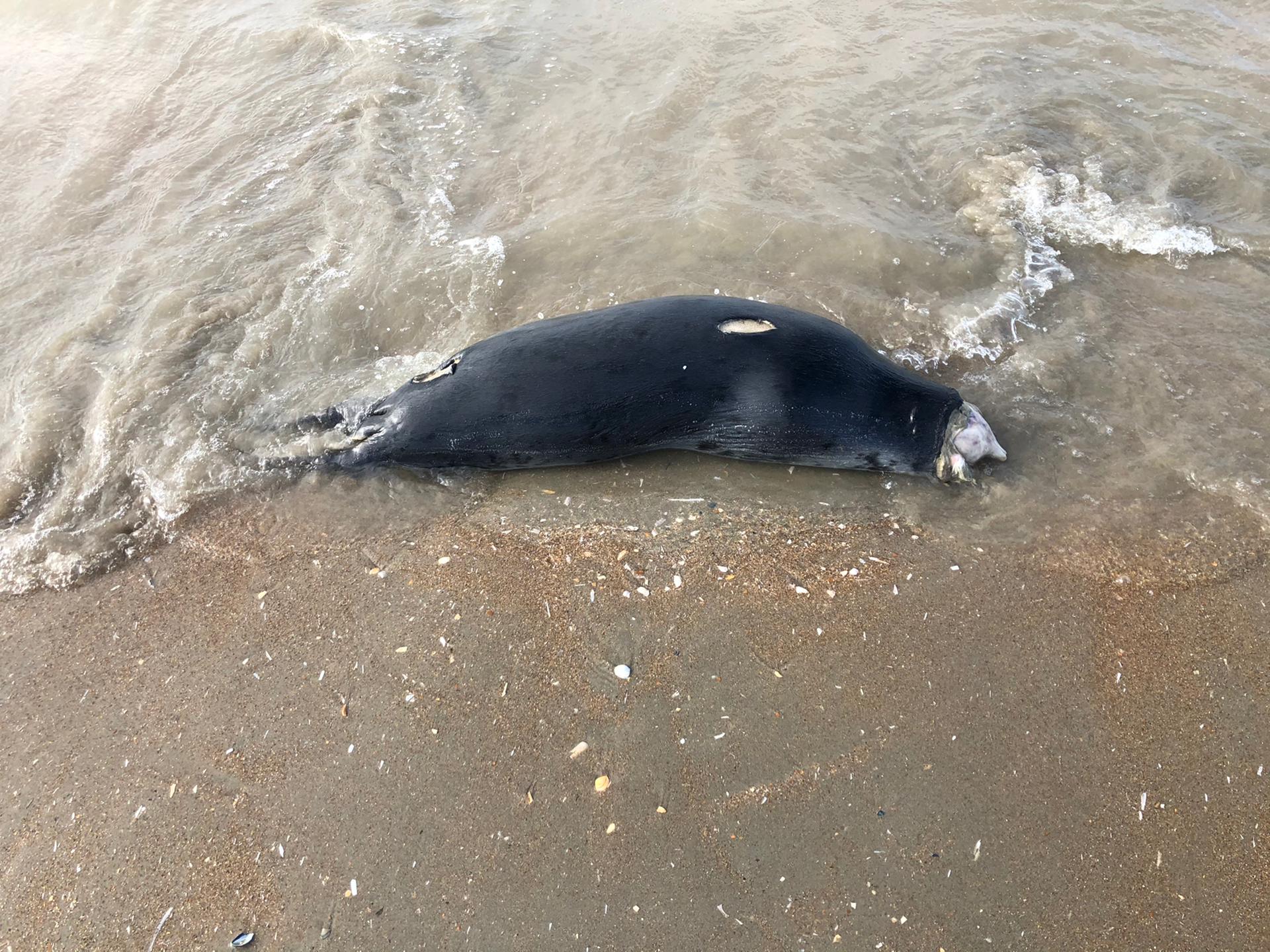
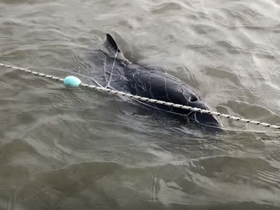
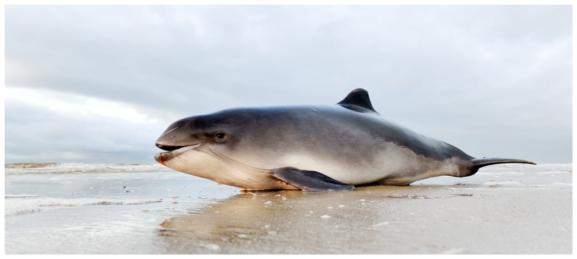
On 8 March 2021 a harbour porpoise got stuck in an illegally placed gill net or entanglement net on the beach of Oostduinkerke (Koksijde). Harbour porpoises that get stuck in such nets drown at the rising tide. This animal (see first picture and subsequent video links) could be rescued just in time by an alert beach visitor. Another porpoise found on the beach in the same area on 4 March appeared to have died very recently and was probably killed in this way (photo at the bottom of the page).
The type of net in question was already banned in Belgium for recreational use at sea in 2001. In 2015, following a court procedure against our country by the European Commission, their recreational use on the beach was also banned. The Royal Belgian Institute of Natural Sciences takes infringements very seriously, and systematically reports violations to the competent authorities. They then take action against the people who placed the illegal nets on the beach.

 The Scientific Committee on Antarctic Research (SCAR) is a thematic organisation of the International Science Council (ISC), and was created in 1958. SCAR is charged with initiating, developing and coordinating high quality international scientific research in the Antarctic region (including the Southern Ocean), and on the role of the Antarctic region in the Earth system. SCAR provides objective and independent scientific advice to the Antarctic Treaty System and other organizations such as the United Nations Framework Convention on Climate Change (UNFCCC) and the Intergovernmental Panel on Climate Change (IPCC) on issues of science and conservation affecting the management of Antarctica and the Southern Ocean and on the role of the Antarctic region in the Earth system.
 The Antarctic Biodiversity Portal (biodiversity.aq) is an international effort of SCAR, that is hosted at the Royal Belgian Institute of Natural Sciences (RBINS). It finds it roots in the Census of Antarctic Marine Life and started in 2005. It seeks to increase our knowledge and understanding of Antarctic and Southern Ocean biodiversity. The SCAR Antarctic Biodiversity Portal is the regional thematic node of the Ocean Biodiversity Information System (OBIS), the Global Biodiversity Information Facility (GBIF) and works closely together with the Southern Ocean Observation System (SOOS). It provides support to publish Southern Ocean biodiversity data and to improve standards and best practices in the collection, management, and publication of marine biodiversity data.