2019 JJ Mehta Award for outstanding contributions to the study of cohesive sediment dynamics goes to RBINS-colleague Michael Fettweis

« Dear Michael, it is my great pleasure to inform you that you have been selected to receive the 2019 JJ Mehta Award for outstanding contributions to the study of cohesive sediment dynamics at the upcoming INTERCOH 2019 meeting in Istanbul, Turkey. » These were the words with which Carl T. Friedrichs, Professor, Research Coordinator & Associate Director of CBNERR-VA at the Virginia Institute of Marine Science, United States, announced the great news to our colleague Michael Fettweis.

The Mehta Award is a given to an individual who has made significant contributions to the advancement in the theory or application of cohesive sediment transport in the marine or aquatic environment. The award, which carries a plaque and a financial prize, is named in the memory of Jayant J. Mehta (1916-1996) by his son Ashish J. Mehta. Jayant J. Mehta (MS, MIT, 1938) was a pioneer in the inception and growth of the petrochemical industry in India, contributing significantly to the country’s industrial expansion starting in the 1970s.”

The selection committee was especially impressed by Michael’s record of combining diverse field observations and innovative analyses to successfully characterize naturally complex cohesive sediment processes while recognizing and quantifying the inherent uncertainties involved. As an awardee, Michael was asked to present an extended keynote lecture during the conference.

The award was presented at the INTERCOH 2019 conference banquet on the evening of Tuesday October 15th, 2019.

Congratulations on this well-deserved recognition of your work, Michael!

RBINS and the Next Generation European Research Vessels

With the construction of the new Belgian Ocean Class RV that is currently ongoing, Belgium is well preparing for a bright ocean science future.

In a new Position Paper, the European Marine Board together with the European Research Vessel Operators (ERVO) group provide a comprehensive look at the European research vessel fleet. The publication presents an overview of the current fleet, its capabilities, equipment and management. It also looks to the future, highlighting what will be needed to ensure that the European fleet can continue to provide the same high level of support to science, in particular in specialized areas such as the deep-sea and Polar regions. It also goes beyond the fleet itself, to consider the training of fleet personnel, fleet management, and the role of research vessels in the wider context of ocean observations.

The further development of our understanding of the ocean is fundamental to address many of the global challenges that society faces today, such as climate change and food security. Although new and autonomous data collection platforms (fixed and mobile continuous measuring equipment and satellites) are increasingly used to investigate, monitor and evaluate the marine environment, research vessels (RVs) remain a key infrastructure that enable scientists to gather data and conduct the research required to expand our knowledge for the purpose of both fundamental understanding and policy support. Physical sampling of the seabed, water column and marine fauna, as well as multi-beam mapping of the seabed, are examples of activities for which RVs remain critical. Also deploying and recovering tools such as moorings, remotely operated vehicles (ROVs), autonomous underwater vehicles (AUVs) and gliders, often relies on RVs.

However, research vessels and their equipment are large and sophisticated, and inevitably costly, infrastructures. It is therefore critical that their importance and indispensable role is clear and that appropriate investments are made to ensure the ongoing provision of scientific support. On November 6th 2019, the European Marine Board (EMB, a strategic pan-European Forum of 33 Member Organizations, including key marine research performing institutes, funding agencies and university consortia) launched a new Position Paper that provides an overview of the current European research vessel fleet and its capabilities, and recommends ways in which it should evolve to meet future science needs. The Position Paper #25 is titled « Next generation European research vessels: Current status and foreseeable evolution » and is the result of a collaboration with the European Research Vessel Operators  (ERVO) group. ERVO is a European platform where RV operators discuss their national activities, projects, problems and plans for the maintenance, modifications and renewal of their research vessels.

Research vessels to address future science needs

The Position Paper describes the current fleet to be highly capable and leading on the world stage. However, with a typical life expectancy of a research vessel of 30 years, the fleet is ageing and urgently requires (re)investment to continue to be as efficient and capable as the scientific community and an effective policy require. Meantime also technology is developing fast and new research arises in specialized areas such as the deep-sea and Polar regions, and research vessels need to keep up the pace. Besides looking to the future needs, the Position Paper also goes beyond the fleet itself, and considers the training of fleet personnel, fleet management, and the role of research vessels in the wider context of ocean observations and the European Ocean Observing System (EOOS).

General recommendations

  • Information and data on the capabilities and equipment of the European research vessel fleet should be kept up to date and be periodically reviewed by the infrastructure owners with support from the European Research Vessel Operators (ERVO) group
  • For the European research vessel fleet to remain capable and fit-for-purpose, both the fleet and its scientific equipment and instruments should be renewed and developed as a matter of urgency
  • The research vessel community should continue on its path towards greater collaboration in order to aim for equal access to research vessel time based on excellent science and not (constrained by) the country of origin of the scientist, for more effective use of resources, for appropriate training for all parties, and for strategic planning of the research
  • Funding agencies should engage in discussions with the research vessel and marine science communities as well as other relevant stakeholders to identify key funding needs
  • The research vessel operator community should continue to look forward to the emerging science and technological developments (e.g. towards real-time data delivery, new autonomous systems, new science frontiers) and work together with relevant parties to ensure that the fleet is ready to support these

Belgian contribution

Belgium is represented in the EMB by the Fonds National de la Recherche Scientifique (FNRS), het Fonds voor Wetenschappelijk Onderzoek – Vlaanderen (FWO), en the Belgian Science Policy Office (BELSPO). BELSPO works closely with the Operational Directorate Natural Environment of the Royal Belgian Institute of Natural Sciences (RBINS) in support of selected EMB Position Papers and for communication aspects. Dr. Lieven Naudts, coordinator of the « Measurement Service Ostend & RV Belgica » group (part of RBINS-OD Nature), was one of the work package leaders in the EMB Expert Working Group on Next Generation European Research Vessels (WG Research Vessels) and is a contributing author of the resulting Position Paper. In June 2019, Dr. Naudts also was elected chairman of the European Research Vessel Operators (ERVO) group during their annual meeting in Hamburg, Germany. « Apart from exchanging experiences, the focus of ERVO in the following years will go to exploring collaboration opportunities to promote common interests and improve the service of RVs to the scientific community, policy makers, funding agencies and even private companies. Requesting the EMB to prepare a new Position Paper on RVs, was a logical thing to do », says Naudts. « With the construction of the new Belgian Ocean Class RV that is currently ongoing at Freire Shipyard (Vigo, Spain), in collaboration with Rolls-Royce Marine AS (now Kongsberg Maritime CM AS), Belgium is well on its way to be prepared for a bright RV future. The new RV Belgica will be technologically cutting edge and ensures the continuation of the Belgian contribution to the much-needed data collection in the marine environment, not only in the North Sea but also in the deep-sea and polar regions. » he adds.

Klas Lackschewitz (GEOMAR, Germany) hands over the chairmanship of ERVO to Dr. Lieven Naudts (RBINS-OD Nature, Belgium) at the University of Hamburg (June 2019).

50 years of protection of the North Sea

On Friday 11 October 2019, the North Sea countries celebrated the 50th anniversary of their Bonn Agreement cooperation in Bonn (Germany). Under this agreement, Belgium, the Netherlands, Germany, the United Kingdom, France, Denmark, Ireland, Sweden and Norway are fighting pollution of the North Sea together with the EU. This regional agreement was founded to combat the pollution of the North Sea by ships and other maritime activities. At the 2019 meeting, Belgium took the initiative to extend the scope of the agreement to include the prevention of illegal air pollution by shipping.

Evolution of the agreement

In 1967 the oil tanker ‘Torrey Canyon’ lost 117.000 tons of oil after being shipwrecked. Shortly after this first major oil spill, in 1969, the countries bordering the North Sea joined forces and concluded to the Bonn Agreement. In this way they help each other in the fight against pollution caused by disasters at sea, chronic pollution from ships and offshore installations. Moreover, they work together in exercising supervision and control.

Oil pollution in the North Sea has fallen sharply over the years, mainly due to the fact that nowadays, illegal oil discharges at sea are rare. This is the result of thirty years of coordinated efforts within the framework of the agreement to detect illegal discharges and to prosecute the polluters caught. However, it is still important to be able to act quickly and collectively in the event of an environmental disaster.

The Belgian delegation. From left to right: Eric Donnay (Head of Unit for Environmental Enforcement at Sea, FPS Public Health, Food Chain Safety and Environment) – Pierre Kerkhofs (Director-General DG Environment, FPS Public Health, Food Chain Safety and Environment) – Ronny Schallier (team leader SURV, MUMM, Royal Belgian Institute of Natural Sciences).

Results of the meeting

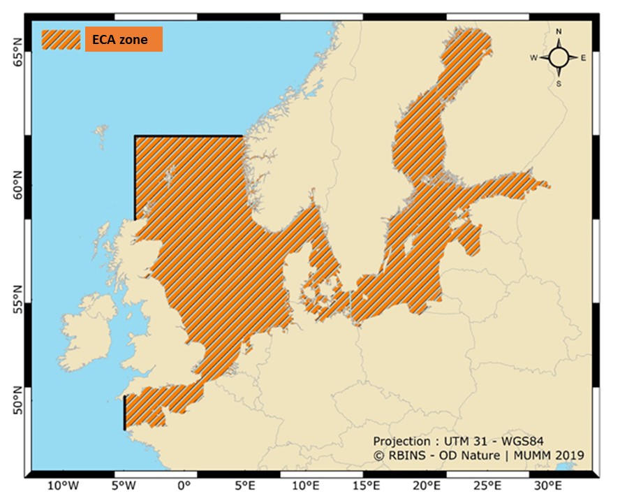
The Bonn meeting took a number of important decisions for the future of the agreement, which were adopted at a ministerial meeting. A new ambitious Strategic Action Plan of the Accord for the next six years was completed. Spain’s accession to the agreement – resulting in the extension of the agreement’s zone to the Bay of Biscay – was formally approved. Another important decision is the extension of the scope of the agreement to include emissions of polluting gases from ships. This was done at the suggestion of Belgium, which is in charge of the organisation of these new activities.

North Sea Minister Philippe De Backer: “This is an international recognition of Belgium’s expertise and pioneering role in protecting the seas and oceans. There is no doubt that this expertise will ensure even more effective controls on compliance with the standards for emissions of gaseous pollutants from ships in the North Sea”.

Implementation in Belgium

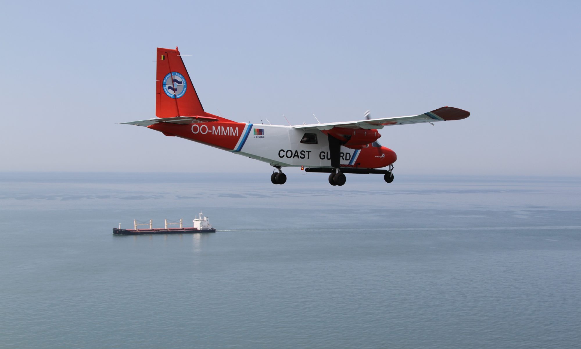
In Belgium, the Bonn Agreement is implemented by MUMM (Management Unit of the Mathematical Model of the North Sea) of the KBIN and the Marine Environment Service of the FPS Public Health. With the new action on the control of emissions from ships, the DG for Maritime Affairs of the FPS Mobility is now also actively involved. They jointly monitor marine pollution with aircraft and patrol vessels and control on board the vessels in the port.

Belgium is internationally regarded as a blue leader in the field of the protection of the seas and oceans. Our country was a pioneer in the field of marine spatial planning, the construction of offshore wind turbines and the fight against plastic waste in the sea. It has also taken international action to halve the CO2 emissions of ships by 2050, and Belgian shipowners are working hard to achieve zero-emission shipping. Moreover, one third of the Belgian part of the North Sea is protected as a Natura 2000 area and Minister De Backer recently confirmed to the United Nations the ambitious ’30×30′ plan to protect 30% of the ocean by 2030. The initiative to extend the scope of the Bonn Agreement in order to better protect the North Sea once again illustrates Belgium’s pioneering role.

More information: www.bonnagreement.org

Minke whale in Belgian waters on 10 November 2019

Big surprise on Sunday 10 November in one of the wind farms in the Belgian part of the North Sea: maintenance technicians observe a whale and can make a short video before the animal disappears under water. The images are delivered to RBINS: it turns out to be a minke whale. A rarity of which only five other cases from Belgian waters are known from the past 20 years. Only two of these earlier cases concerned live animals.

On Sunday 10 November, maintenance technicians were left stunned when they saw nothing less than a whale swimming past a wind turbine. The observation took place in the Norther concession zone, about 23 km from the port of Zeebrugge. Kenny De Groote succeeded in making a short video, which was sent to scientists of the Royal Belgian Institute of Natural Sciences for documentation.

« The images unmistakably show a rorqual, and the short fragment is fortunately of sufficient quality to identify the animal as a minke whale. » says Kelle Moreau, who was the first to receive the images and forward them to his colleagues. « Based on the overall impression of size and shape of the animal, and especially because of the extensive white zones at the base of the pectoral fins (flippers), I immediately thought of a minke whale » adds Jan Haelters, marine mammal expert from RBINS. « The shape and location of the dorsal fin, and the presence of a lighter zone behind the pectoral fins (the so-called « chevron »), also contribute to the identification that was confirmed by several consulted experts. »

Characteristics of the minke whale (© Whale Watching Handbook, International Whaling Commission)

Adult minke whales (Balaenoptera acutorostrata) reach a maximum size of 9 to 11 meters, with females becoming slightly larger than males. The minke whale is one of the smaller species of baleen whales, and is not considered a rare or endangered species.

A minke whale usually doesn’t show more than its back (© Mike Baird)

Although the minke whale is part of the fauna of the North Sea, its range is mainly limited to its northern and central part. The species is rarely found south of the Dogger Bank. However, research has shown that minke whales more often occur more to the south in recent years, probably as a result of changes in the ecosystem. From the Belgian waters, only the following cases are known to us from the last 20 years:

  • 2004: found dead at sea and landed; victim of by-catch
  • 2013: stranding; died by swallowing a large amount of plastic
  • 2013: observation at sea
  • 2017: decomposed carcass at sea
  • 2017: observation at sea

The skeleton of the minke whale from 2004 (owned by RBINS) can currently be admired in the permanent exhibition ‘Sea Change’ in the Provincial Visitor Centre Duinpanne in De Panne.

Skeleton of the Belgian minke whale from 2004, exhibition ‘Sea Change’, Duinpanne, De Panne (© RBINS/Kelle Moreau)

‘The Ocean We Need’ – Europe’s Leading Ocean Experts Launch Advice For Governments

The European Marine Board has recently launched a publication, titled ‘Navigating the Future V’, which will provide European governments with robust, independent scientific advice and expert opinion on future seas and ocean research to 2030 and beyond. To achieve this, leading ocean experts have identified the key areas of marine science where there are still gaps in knowledge.


The European Marine Board (EMB) is a leading European think tank in marine science policy. It is an independent non-governmental advisory network with a membership comprising more than 10,000 marine scientists from the major national marine/oceanographic institutes, research funding agencies and national networks of universities from countries across Europe. The Board provides a platform for its member organizations to develop common priorities, to advance marine research, and to bridge the gap between science and policy to meet future marine science challenges and opportunities.

Navigating the Future V

The knowledge gaps that Navigating the Future V (NFV) advises to prioritise in the research agenda is critical in understanding the four-dimensional ocean, to predict tsunamis and the impact of multiple stressors on biogeochemistry and biology, and to understand the impact of the future blue economy on our marine ecosystems. NFV shows that we need transdisciplinary science and sustainability science to address the management of a holistic four-dimensional ocean. It also highlights the technological advances and modelling needed for a possible future virtual ocean that would enhance public engagement and understanding of the ocean.

NFV proposes the science we need for the forthcoming United Nations Decade for Ocean Science for Sustainable Development (2021-2030), the next European Framework Programme, Horizon Europe, and its Mission on Healthy Oceans, Seas, Coastal and Inland Waters. The report was officially launched on 11 June 2019 in Paris, France, at the EurOCEAN 2019 Conference (High-level science-policy conference co-organised by European Marine Board, the European Commission and the Intergovernmental Oceanographic Commission of UNESCO).

Key Messages

Specifically, the report recommends a solutions-oriented marine research agenda, co-designed with all stakeholders, and with the governance of sustainability at its core. It should address the following key knowledge gaps:

  • The four-dimensional ocean (changes in the three-dimensional ocean over space and time) and functional links between the components of the marine system, i.e. physics, chemistry, biology, ecology and humans;
  • The impact of multiple stressors (e.g. climate change, pollution, overfishing) on the functioning of marine ecosystems, their interactions, evolution and adaptation over time, and the ecosystem services they provide;
  • The characteristics, probability and impacts of climate-related extreme events and geohazards (e.g. marine heat waves, meteotsunamis and submarine earthquakes, landslides, volcanic eruptions and their associated tsunamis) and how these might change under climate change; and
  • Ocean technologies, modelling, data and artificial intelligence needed for sustainable ocean observations to understand, predict and manage human impacts on the ocean.

Key actions include the development of a business model ensuring the long-term economic sustainability of ocean observations. We also need to develop a new generation of sustainability scientists and establish a sustainability forum within Europe bringing together all actors including industry and civil society.

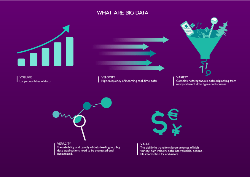
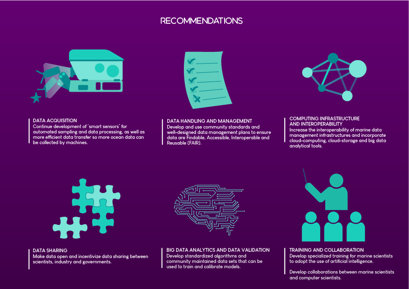
The key messages and actions are also explained in a set of infographics (see below).

The report has been a collaborative effort starting in November 2017 with a planning meeting of 19 leading European experts in the field of marine science and related disciplines to decide on the high-level content. Larger collaborative working groups with representatives from 13 European countries then worked to identify knowledge gaps and draft the recommendations of the report.

The Belgian Federal Government is represented in the European Marine Board by the Belgian Science Policy Office (BELSPO). A scientific communicator from RBINS is delegated for communication aspects and membership of the European Marine Board Communications Panel (EMBCP).

Reanalysis of the first results

Sunday 13th of October 2019

After 10 busy days full of working and adjusting our work, we finally managed to make the temperatures measured at the port presentable and in a good format.

After ten days of hard work the team (Zacharie, Katrijn, Sylvain, Wilfried, Medard and field expert Victor) finally have the confidence to test there sensors in the field

After reanalysing the data of 3 and 4 October and comparing them with the GPS shield output we can come up with the following results:

Results of the sensor left at the port of Cotonou

The conclusion of these measurements is that the system is too unstable to produce good results and the gps module uses a lot of battery. After removing the GPS module and stabilizing the system we found the following results:

The conclusion of these measurements is that the addition of shock absorbers  proved very beneficial, there was one power cut that happened during the recollection of the system. The results can be positioned in time in a reliable manner.

On monday, when we will analyse the results gathered during the weekend, we will see if these conclusions can be hold in a real experimental set up.

Putting the system to the test

Friday, October 11th 2019

Report and pictures: Medard Honfo, Katrijn Baetens

After several days of preparation, a stable system was developed so we have the confidence to put the system to the test on the lake itself. After the last verifications our team (Zacharie Sohou, Katrijn Baetens, Medard Honfo, Sylvain Amoussou) and Mr Victor Okpeitcha,an oceanographic ingeneer of IRD/IRHOB took “une pirogue”, a local type of boat, to deposit three thermometers. The stations were next to existing stations of IRD/IRHOB, this will help the validation of our system and avoid double work.

Map of the positions were the sensors are released.
Station 1 (yellow) in the middle of the canal.
station 2 (orange) in the middle of the lake, this was not evident, luckily we got help from local fishermen
Station 3: A permanent station installed by IRD/IRHOB (blue)

Methodology used to install the sensors:

Step 1: fix a perforated pipe in the water

Step 2: Put the sensor inside, the sensor will float on the water

Step 3: close the system and put a lock on it

Fixing the sensors was not always straightforward

Production of more sensors and connection to the internet

Thursday October 10th 2019

Reporter: Wilfried Sintonji

Photos: Katrijn Baetens et Wilfried Sintonji

Today the students working on this project have assembled and configured their sensors independently. They also tested other types of containers made of local materials.

The new container type indeed was waterproof
The students working together to get the configuration of their sensor right.

Today we finally managed to attach the module system to our sensor, unfortunately we did not arrive to make it reliable enough to attach it to the operational system.

The first succesfull messages sent by the sensor

We ended the day by recollecting the second testtype we deposited at the port yesterday.

Adding a shock absorber to the system

Tuesday the 8th of October 2019

Reporter: Médard Honfo

Pictures: Katrijn Baetens

Today we kept improving the system, we noticed the data gaps originated from small shocks that the batterie containers were not able to absorb, hence we searched for different methods to add a shock absorber to the system. The pictures show some of the ideas we had, in the end we kept it simple and just added some padding to the box. In the evening we put the box back to the port for a second test.

Investigating different methods for a shock absorber


First data gave insights in how to improve the sensor

Monday 7th of October 2019

Report and figure: Sylvain Amoussou

Pictures: www.lastminuteengineers.com

We analyzed the data of the first prototype. The prototype has been activated at 5 pm on Friday, October 2019 as Wilfried described in the last report.
The figure shows the temperature measured by the prototype from 5 pm local time on Friday. The figure1 (a) shows that the temperature is almost constant from 5 pm to around 7 pm, the temperature decreases and oscillates overnight. The figure 1 (b) show the temperature from 12 am to 8am UTM time. The temperature still oscillated from 12 am to 5 am UTM. But after that, the temperature is almost constan, the oscillations started  when the sun went down and stopped when it went under.

Data gathered with the prototype during 3 October (a) and 4 October (b)at the port of Cotonou.

Today we also further improved our model:

  • The prototype has stopped for during the night, luckily it started back independently.
  • We verified the voltage on the batteries. We noticed that the remaining voltage was 6,28 V which is half of the 12V of the fully charged battery pack. We still need to further investigate if this is acceptable.
  • In the future we would like to use a gsm module in stead of a gps module, this will allow to transfer data without having to open the box. We found a solution to charge the lithion/ion battery that charges this module.
Electronic scheme from https://lastminuteengineers.com, a very helpfull site for developing arduino projects