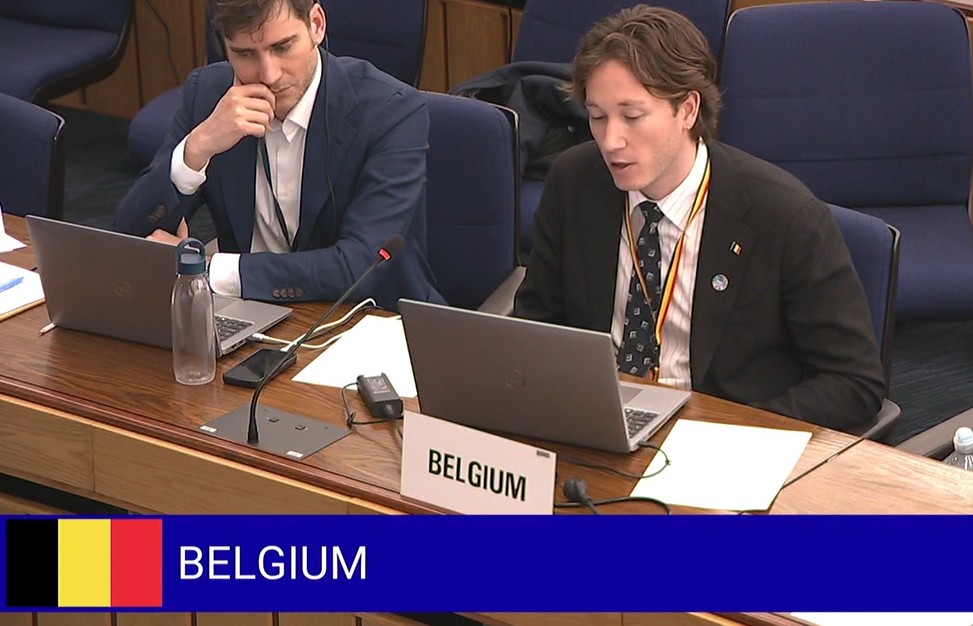
From 9 to 13 February, Marie-Lucie Susini (FPS Mobility and Transport, Head Of Delegation), Diederik Wéreau (FPS Mobility and Transport) and Jean-Baptiste Merveille (Institute of Natural Sciences) represented Belgium at the 13th meeting of the Sub-Committee on Pollution Prevention and Response (PPR13) of the International Maritime Organisation (IMO) in London, United Kingdom.
Belgium actively contributed to discussions on atmospheric emissions from ships, with a particular focus on nitrogen oxides (NOx). Our delegation supported the development of effective international regulations in this area and engaged in technical debates to ensure that future standards deliver real and measurable emission reductions.
A key strength of the Belgian contribution is evidence-based monitoring: since 2020, Belgium has been monitoring NOx emissions from ships at sea with the coast guard aircraft, providing valuable insights to inform international policy development.
The PPR13 session laid a constructive foundation for further work, marking the beginning of a multi-year process that will continue for at least two more years.
In parallel, the Belgian study on black carbon emissions was referenced several times during discussions on reducing the impact of black carbon in the Arctic, highlighting the relevance of our research at the global level.
Belgium remains fully engaged throughout the discussions, reaffirming its commitment to sustainability, science-based policy, and international knowledge sharing.
Researchers from the Institute of Natural Sciences confirm the survival and growth of juvenile European flat oysters introduced in July 2025 as part of the BELREEFS project. The follow up is possible through a smart monitoring programme that allows for rigorous, long-term mapping of reef development. The results of the first monitoring campaign evidence a promising start for Belgium’s offshore restoration of European flat oyster reefs.
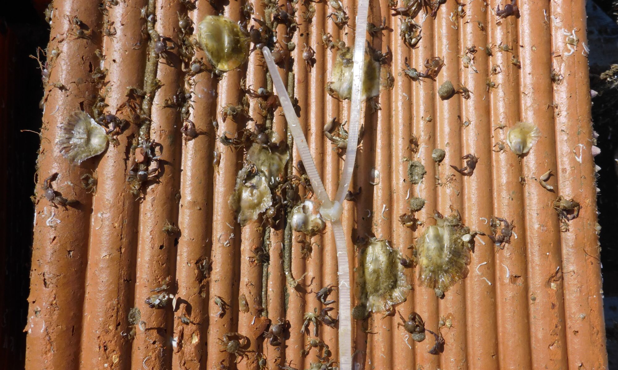
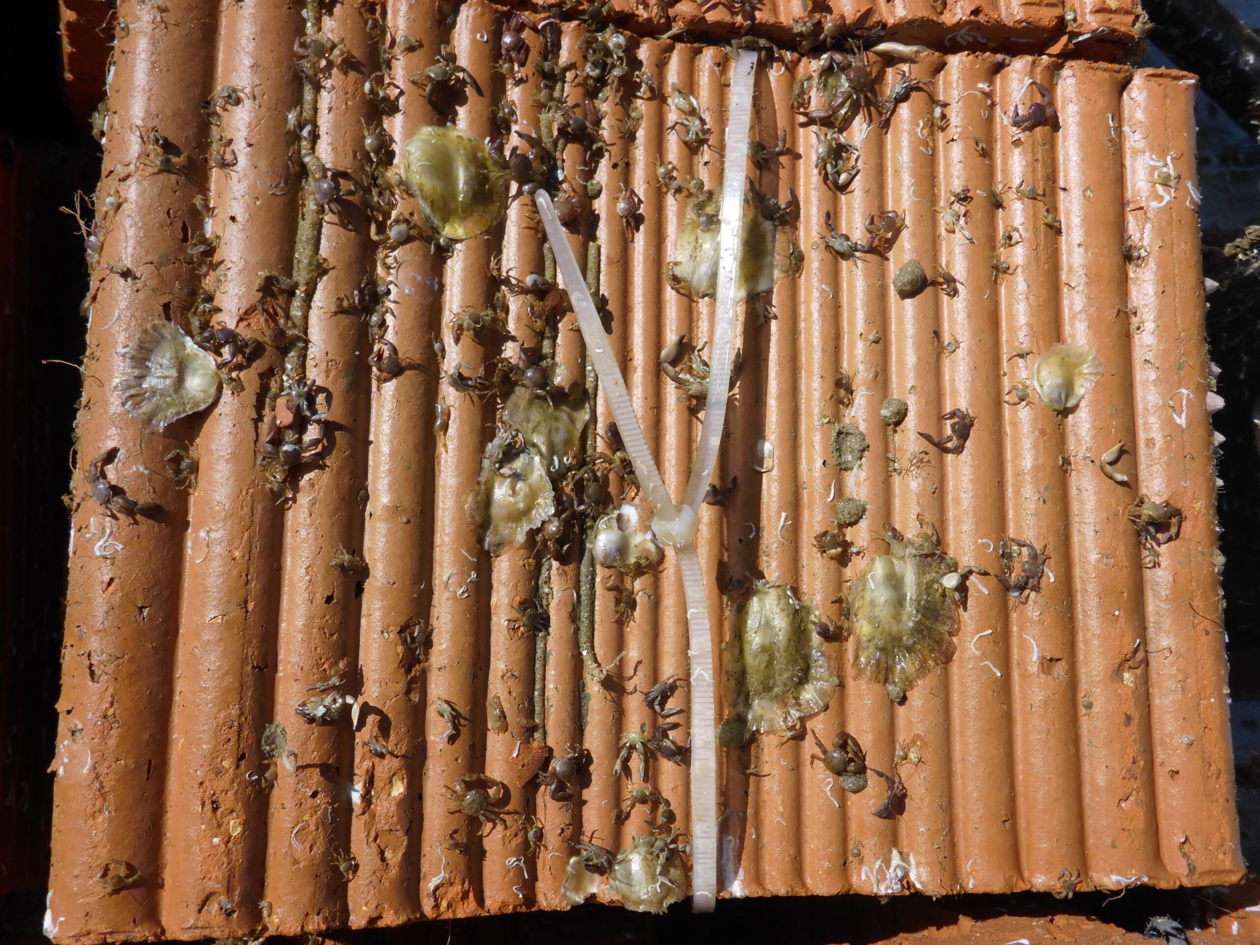
In July 2025, more than 200,000 juvenile European flat oysters (Ostrea edulis) were installed on the seabed of the Belgian part of the North Sea, approximately 30 km off the coast at a depth of 30 m. The oysters were seeded onto biodegradable clay bricks, making so-called “spat-on-substrate”, which were then installed at a carefully selected location with natural hard substrate (gravel) within the Natura 2000 area ‘Vlaamse Banken’. European flat oysters are so-called ecosystem engineers: they form reefs that create habitat for countless other species, and as filter feeders they help to keep the water clear. However, due to overfishing and habitat destruction, this important native species almost completely disappeared from our country.
The extensive deployment was part of BELREEFS, the first offshore pilot project which focuses on restoring European flat oyster reefs in Belgian marine waters. The BELREEFS project, commissioned by the Belgian Federal Government (Department for the Marine Environment of the Federal Public Service Health, Food Chain Safety and Environment), brings together expertise from Jan De Nul Group, the Institute of Natural Sciences (Marine Ecology and Management team – MARECO), Shells & Valves and Mantis Consulting. The techniques tested in the project will inform future large-scale restoration efforts, contributing to Belgium’s broader vision for meeting nature restoration targets, particularly within protected Natura 2000 areas.
Smart monitoring
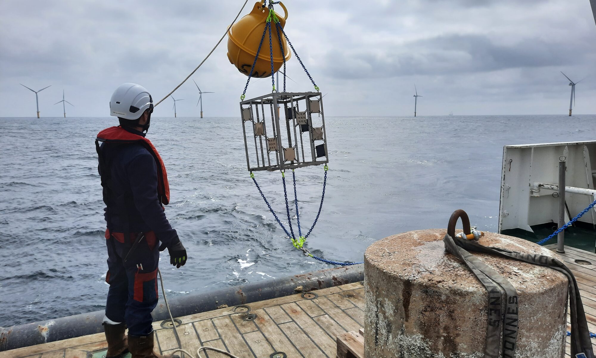
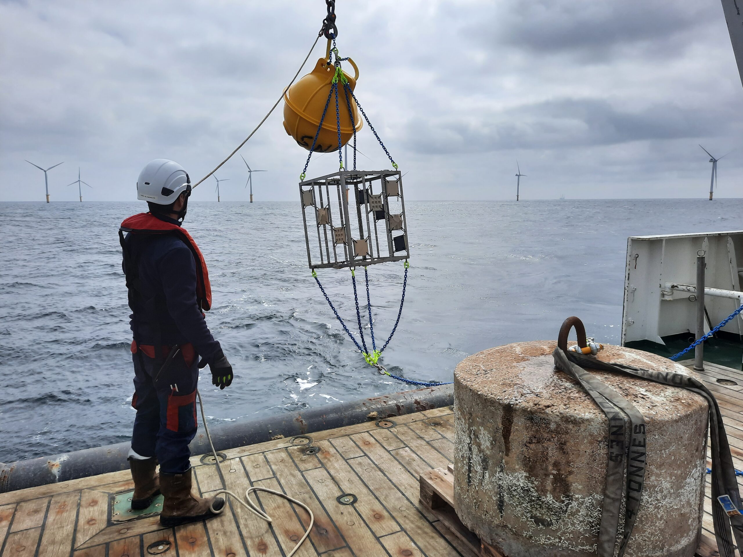
The BELREEFS monitoring team of the Institute of Natural Sciences has developed a thorough plan to monitor the reef development, closely following key metrics developed by the Native Oyster Restoration Alliance (NORA), while adapting protocols to the challenging offshore conditions of the North Sea. This approach will enable BELREEFS to generate data that are comparable across European restoration initiatives. Several of these metrics require retrieving spat-on-substrate for analysis, necessitating a tailored monitoring approach.
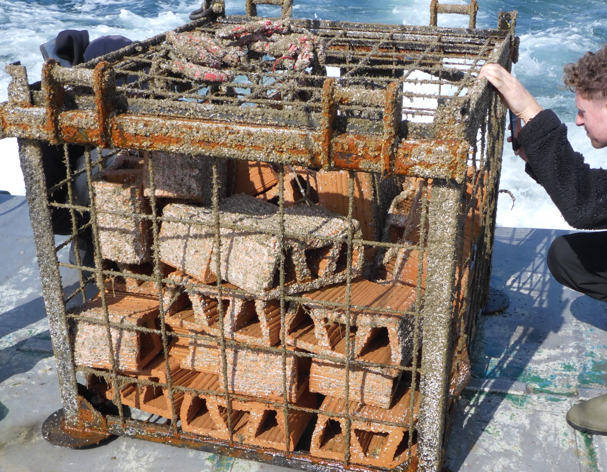
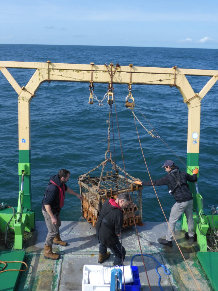
To ensure effective data collection, custom-built monitoring cages were designed by Jan De Nul to enable long-term monitoring in a reliable and standardised manner. Each cage contains a selection of clay bricks, seeded and un-seeded, with wide spaces to allow exposure to the surrounding environment. The cages can be routinely deployed and retrieved either through the integration of an acoustic release mechanism, provided through the activities of the Institute of Natural Sciences within the European Marine Biological Resource Centre Belgium (EMBRC Belgium), or by scientific diving.
With the help of the crew of the STREAM, the first monitoring cage was successfully brought up to the surface in September 2025 using the acoustic release system. On site, the researchers measured oyster survival, growth, density and successfully inspected for new oyster spat settlement. Biodiversity assessments included the identification of sessile and mobile fauna on the substrate, with several smaller and challenging specimens collected for lab identification.
All samples have now been processed. While oyster survival and growth were confirmed, observations also revealed the occurrence of active ecological interactions on the reef substrate. Signs of competition for space and presence of potential predators were noted, and these dynamics will be further investigated during the follow up monitoring phases in the coming years.
“The first monitoring yielded some promising results. We are looking forward to the results of the coming years and hope that the small oysters will grow into a self-sustaining reef, right at the spot where large oyster reefs existed more than a century ago. The fact that we also found colonization by wild oyster spat makes us even more enthusiastic. This is a highly encouraging sign for future restoration efforts.” – Thomas Kerkhove – MARECO, Institute of Natural Sciences
The BELREEFS monitoring programme will continue over the coming years with the retrieval of two more monitoring cages. These long-term observations will provide additional insights into reef development, ecological interactions and overall restoration success in the dynamic offshore conditions. Such information will be crucial for upcoming large-scale restoration plans in the Belgian part of the North Sea, and will further contribute to the shared knowledge gathered over the last decades on flat oyster restoration across Europe.
BELREEFS is a collaboration between Jan De Nul, the Institute of Natural Sciences, Shells & Valves, and Mantis Consulting. It is being carried out on behalf of the Federal Public Service Health, Food Chain Safety and Environment as part of action T4.8 of the LIFE B4B project (101069526).
The oysters were cultivated in collaboration with the Dutch Stichting Zeeschelp and Oyster Heaven (Mother Reef). For all our projects, we collaborate with international experts from the Native Oyster Restoration Alliance (NORA) and follow their guidelines. This allows us to utilize the best available knowledge, advanced technologies, and leading experience.
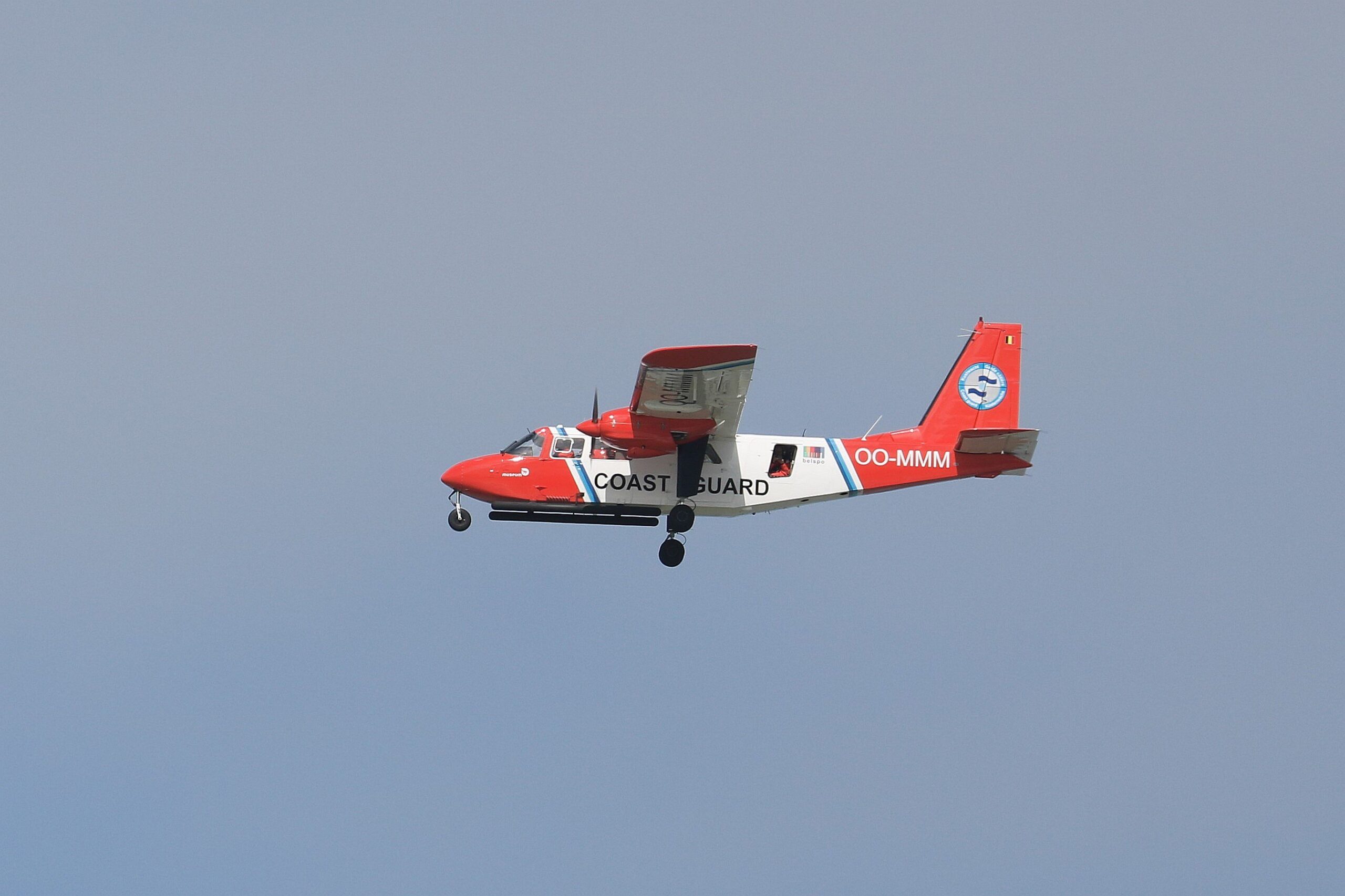
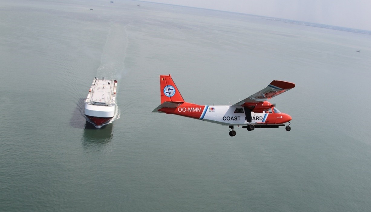
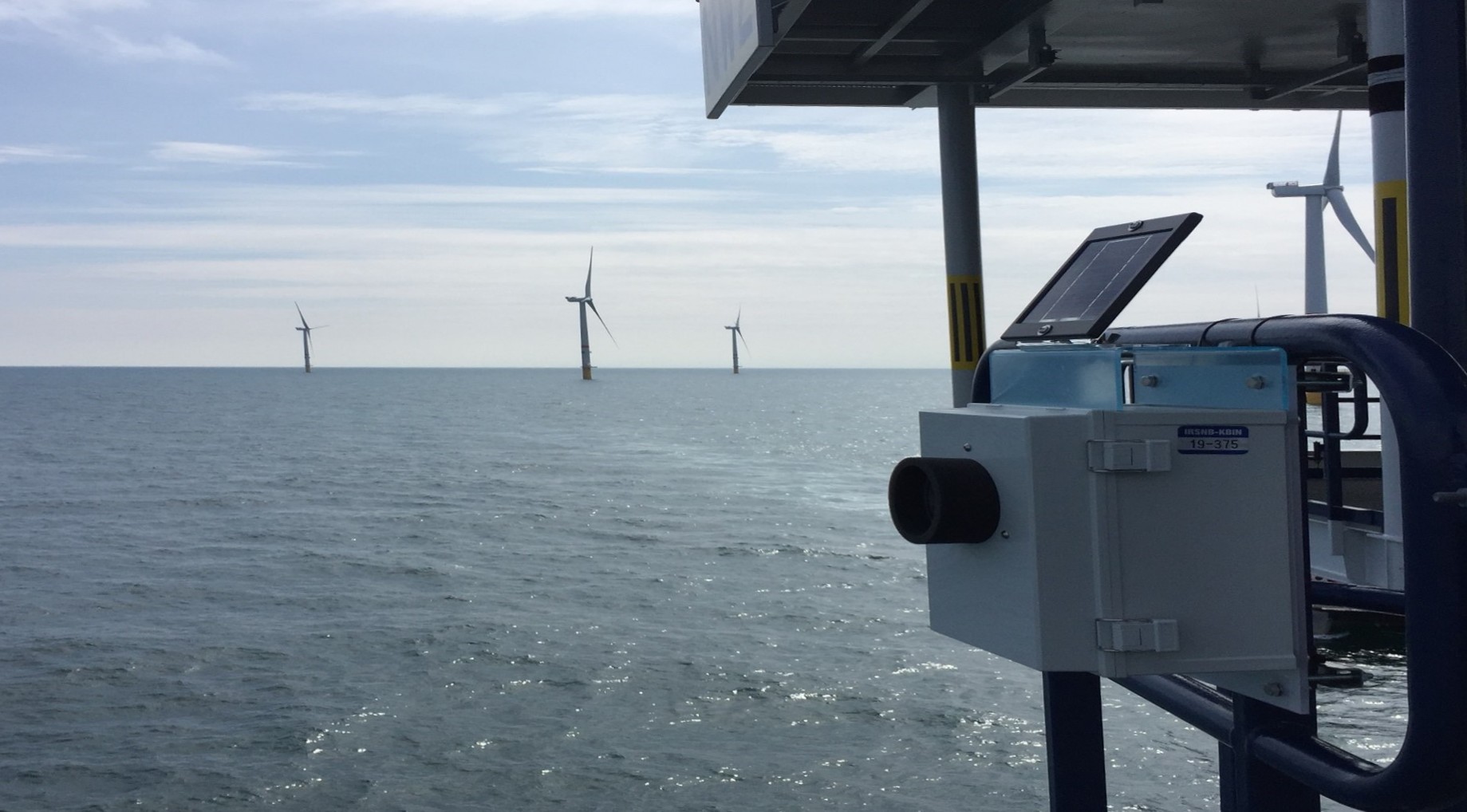
Black carbon emissions from ships in the southern North Sea were surveyed using the sniffer sensor of the Belgian coastguard aircraft. The preliminary results show that these emissions are higher than previously assumed and provide scientific support for the development of international regulations and sustainable maritime policy.
Since 2015, the Belgian coastguard aircraft has been equipped with a sniffer sensor that can measure the concentration of pollutants in emissions from ships at sea. Initially, the system was integrated into the aircraft to monitor and analyse sulfur oxide (SOx) emissions, but over the years it has been expanded to include the ability to detect other pollutants. Since 2020, nitrogen oxides (NOx) have also been measured, and in 2021, black carbon also became part of the air monitoring mission.
In June 2025, the aerial surveillance team published a scientific article in Atmosphere describing black carbon emissions from maritime traffic in the southern North Sea and the English Channel based on 886 measurements taken between 2021 and 2024. This is the first scientific study of this scale to compile and analyse actual measurements of black carbon from ships. The measurements were taken in the maritime areas of Belgium, the Netherlands, France and the United Kingdom.
What is “black carbon”?
Black carbon is a category of carbon-containing fine particles smaller than 2.5 micrometres (1 micrometre or 1 µm is equal to one thousandth of a millimetre). It mainly comes from the incomplete combustion of carbon-containing fuels such as fossil fuels (like diesel and coal) but also biomass (wood) and biofuels.
As a fine particle, black carbon has an impact on the health of the population exposed to it. Although the exact climate impact of black carbon remains a subject of debate and it is not classified as a greenhouse gas, it is clear that it contributes significantly to climate change. This is partly due to its ability to absorb solar radiation when it settles on polar ice, making it darker.
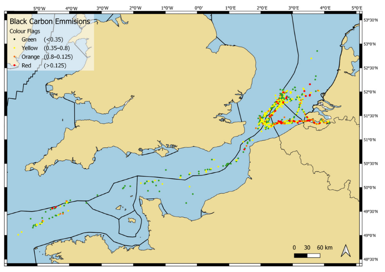
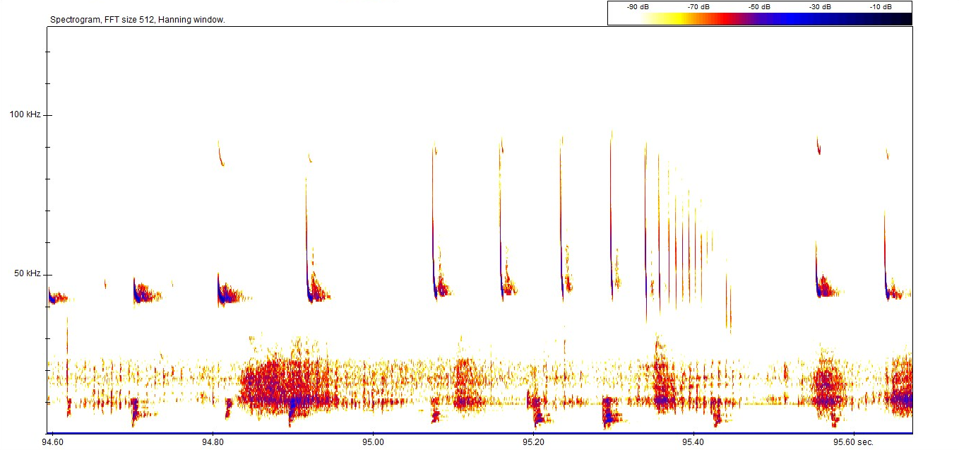
Spatial distribution of black carbon emission measurements, with colours indicating the measured levels (in g black carbon/kWh)
Interpretation of the results
The long-term research led to a number of conclusions that will be refined in the future with additional data. The main conclusion is that air measurements of black carbon emissions from ships at sea are feasible and that the accompanying observation protocol provides valuable information about the actual extent of these emissions. Until now, such information has been derived from measurements taken under controlled and simulated conditions rather than at sea under real conditions.
The data also suggest that black carbon emissions from ships may have been underestimated. It also appears that ECA-compliant fuels (low-sulphur fuels permitted in the “emission control area” to which the North Sea belongs) contribute to a significant reduction in black carbon emissions. In addition, it also appears that engine load is a determining factor for black carbon emissions.
Science in the service of enhanced sustainability
Black carbon emissions from shipping are not yet regulated, although discussions have been ongoing since 2011 to find the best ways to limit these emissions and their impact. These discussions are taking place within the International Maritime Organisation (IMO), a specialised agency of the United Nations responsible for establishing international rules relating to the safety and security of maritime transport, but also in relation to the prevention of marine and atmospheric pollution by ships.
As a basis for such discussions, the IMO naturally needs robust scientific data, and this is where the new Belgian insights can play a valuable role. Belgium, represented in the IMO by the Directorate-General for Shipping (Federal Public Service Mobility and Transport), brought the research conducted by the Institute for Natural sciences to the attention of the international maritime community here on 21 November 2025. In this way, Belgium aims to raise awareness of the issue of black carbon and provide concrete elements to support the development of effective regulations on black carbon emissions from shipping.
On 26 November 2025, Belgium was also elected as a member of the IMO Council in London, thanks to the ongoing efforts of DG Shipping. The election, formalisation and presentation of Belgian scientific insights to the IMO demonstrate the importance our country attaches to international scientific and political cooperation and its strong support for the transition to a sustainable and less polluting shipping sector.
The coastguard aircraft is owned by the Institute for Natural sciences and is piloted by Defence pilots. The scientific service Management Unit of the Mathematical Model of the North Sea (MUMM) of the Institute of Natural Sciences is responsible for implementing the national programme for aerial surveillance of the North Sea and provides the scientific operators of the aircraft.
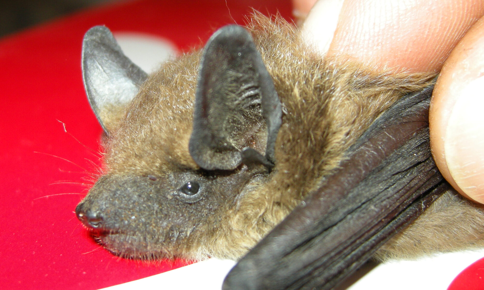
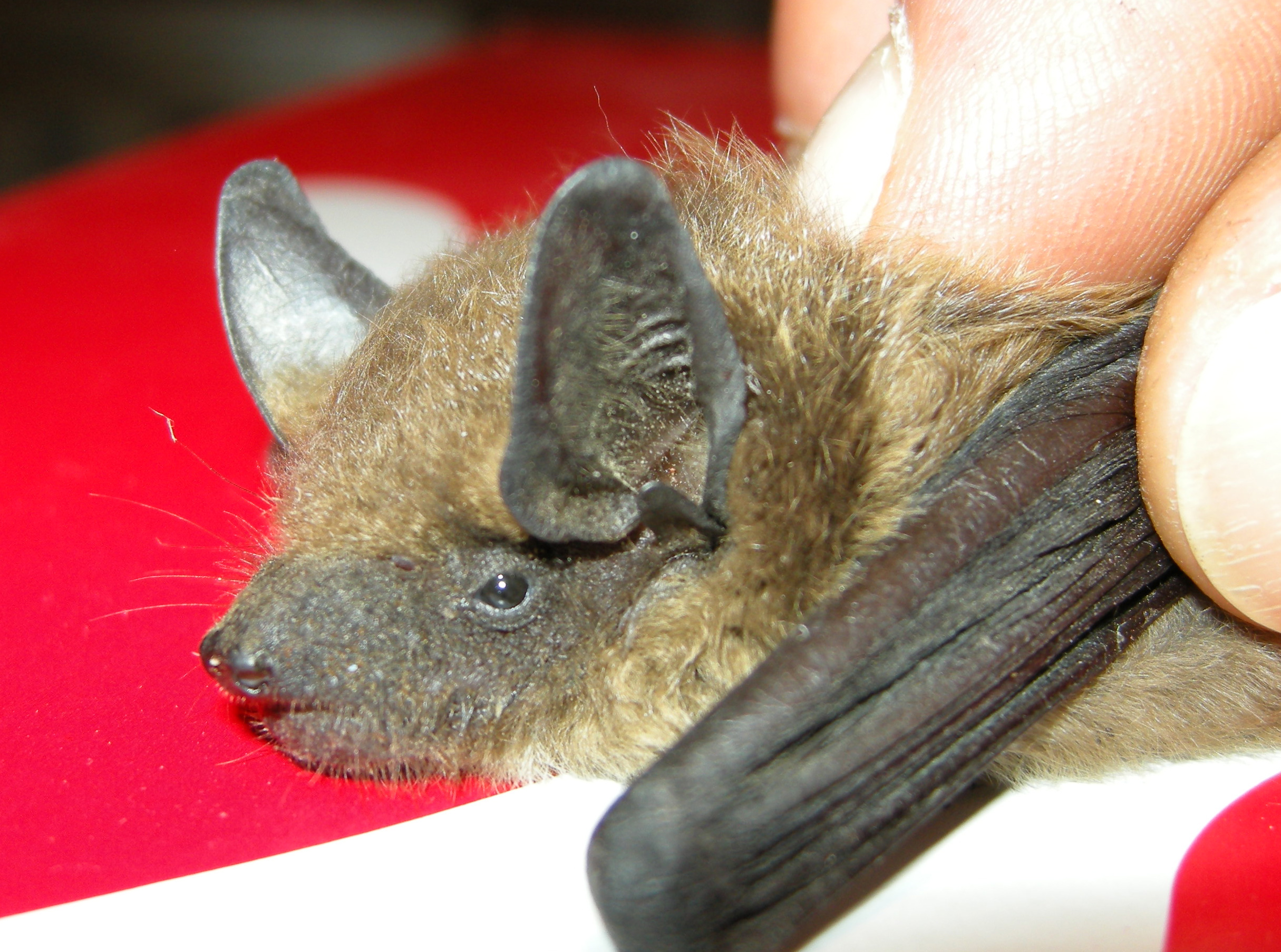
Researchers and nature enthusiasts can now listen to nearly two million Belgian bat recordings through the Digital Animal Sound Archive. The platform provides central access to this extensive sound material, supports scientific research, and encourages its use in environmental impact analyses and policy development.
Like many other animal species (including whales, insects, birds, etc.), bats produce sound, partly to locate prey or for orientation. These are high-frequency ultrasonic sounds that are often inaudible or difficult for humans to hear, but can be recorded. Such recordings have great potential for research into the distribution and behaviour of various species, and for assessing the impact of human activities. This applies both on land and at sea, as bats are also observed in the marine environment.
Until now, the available Belgian bat sound files were stored only in the difficult-to-access archives of individuals or organizations. There, they ran the risk of disappearing in the short term, for example, because they were deleted after analysis. The Digital Animal Sound Archive (DASA) now brings the recordings together in a single, standardized, secure, and searchable system.
DASA is more than a passive audio archive of professional scientists. After creating an account, anyone interested, both professionals and volunteers, can download and listen to audio recordings. Furthermore, every member can upload recordings to DASA. This allows citizen scientists to preserve their own recordings for the future, thereby expanding the collection and increasing its potential for scientific and policy-supporting applications. To date, 24% of observations have been collected by citizen scientists, a share that will undoubtedly increase in the future.
Furthermore, anyone can contribute to assigning recordings to one or more suspected species, or assign an alternative species option to an existing identification. Identifying which species a recording refers to is not always easy in the case of bats and requires extensive knowledge of the subject. Therefore, bat specialists are specifically engaged to validate observations, meaning they are assigned to the correct species with a high degree of certainty.
A wealth of information
“DASA currently bundles nearly two million bat detections by professional and citizen scientists. It’s a unique database that future-proofs the application of observations and sound recordings for Belgian nature research,” says project coordinator Robin Brabant of the Institute of Natural Sciences.
About half of these bat observations are linked to sound files. However, the remaining observations are also very valuable because they can be used to determine the distribution and trends of the various species.
Bob Vandendriessche, chair of Natuurpunt’s Bat Working Group, further elaborates on the added value of a dedicated platform like DASA: “Existing platforms like observation.org (waarnemingen.be in Dutch, observations.be in French) aren’t designed to receive and share such massive datasets. While the number of individuals collecting acoustic data on a large scale may be relatively small, the data volume can quickly become very large. The size and importance of the accompanying metadata is also much greater than with other biological data, making a separate platform desirable.”
DASA is the first Belgian platform to structure bioacoustic data according to international standards and link it to international biodiversity platforms such as the Global Biodiversity Information Facility (GBIF). The infrastructure is also scalable. In addition to bat sound recordings, recordings from other animal groups, such as marine mammals and insects, will later be added. However, the focus remains on Belgian data.
The Digital Animal Sound Archive (DASA) project is a collaboration between the Institute of Natural Sciences, Natuurpunt, and Natagora. The platform was developed with funding from the Belgian Science Policy (BELSPO).
All data comply with the FAIR principles (Findable, Accessible, Interoperable, Reusable) and the European Open Data Directive, making them usable worldwide for science, policy and education.
On December 9th, the tenth anniversary of the Belgian branch of the European Marine Biological Resource Centre was celebrated at the Institute of Natural Sciences. Over the past decade, the initiative has significantly strengthened access to high-quality research infra-structure, expertise, and international collaborations. The anniversary day provided the ideal opportunity to reflect on this impact and to set a course for the coming years, emphasizing collaboration, sustainability, and scientific innovation.
The Belgian branch of the European Marine Biological Resource Centre (EMBRC-BE) looked back on ten years of work on Tuesday, December 9, 2025. EMBRC-BE is part of the pan-European research network EMBRC-ERIC (European Research Infrastructure Consortium), which aims to increase our knowledge of the biodiversity and functioning of European coastal seas. EMBRC-ERIC supports and streamlines marine research throughout Europe by providing researchers with access to highly equipped laboratories in marine stations and research institutions.
The marine environment covers 71% of our planet’s surface and is crucial for all life on Earth and a wide range of human activities. Seas and oceans produce approximately half of all the oxygen we breathe. They store large amounts of CO2, thus buffering the effects of climate change. At the same time, they are a source of food, energy, and employment for millions of people worldwide.
“The marine environment is also increasingly being used as a location for renewable energy production or aquaculture. It’s therefore crucial to fully understand how the marine ecosystem works and how we can sustainably use marine resources,” explains Jan Vanaverbeke of the Institute of Natural Sciences and Ghent University, who was involved in launching EMBRC-BE.
Marine research remains a challenge
However, researching the marine ecosystem is no easy task. Access to the sea is not always straightforward, and the specialized instruments required are often expensive and difficult for many research groups to obtain. EMBRC Belgium helps remove these barriers. The consortium combines the strengths of Belgian marine research institutions and makes high-quality infrastructure and expertise accessible to anyone who wants to conduct research on or with marine organisms.
“This way, excellent science is not hampered by practical concerns, and potentially groundbreaking research is not hindered by local constraints,” says European EMBRC Director Nicolas Pade, who has come to the celebration at the Institute of Natural Sciences for the tenth anniversary of the Belgian branch.
Since 2025, Marleen De Troch (Ghent University) has been at the helm of the Belgian hub as its new director. Her ambitions for the coming years are clear: further promoting collaboration between research groups, supporting young researchers, and strengthening the bridge between science, policy, and the blue economy.
Marleen De Troch: “This funding makes a significant difference. We support important Belgian innovation areas in the blue economy, ecology, and nature conservation, such as the development of floating solar panels, sustainable aquaculture, and oyster reef restoration. EMBRC-BE’s scientific services have also led to more than 300 scientific publications over the past ten years.”
The ever-expanding expertise and resulting international reputation of the Belgian marine scientific community have also allowed Belgian researchers to participate in 40 European research projects. This way, a significant amount of funding flows back to our research institutions.
“Our goal remains the same: lowering barriers, encouraging collaboration, and strengthening marine research in Belgium. We also want to focus even more on innovation, knowledge sharing, and sustainability over the next ten years,” concludes De Troch.
EMBRC-Belgium is a collaboration between various research groups from Ghent University, the Flanders Marine Institute (VLIZ), Hasselt University, KU Leuven, and the Institute of Natural Sciences, and is funded by Flemish and federal research funds. Within this EMBRC collaboration, the Institute of Natural Sciences strengthens the consortium with its monitoring activities and specialized research on artificial reefs.
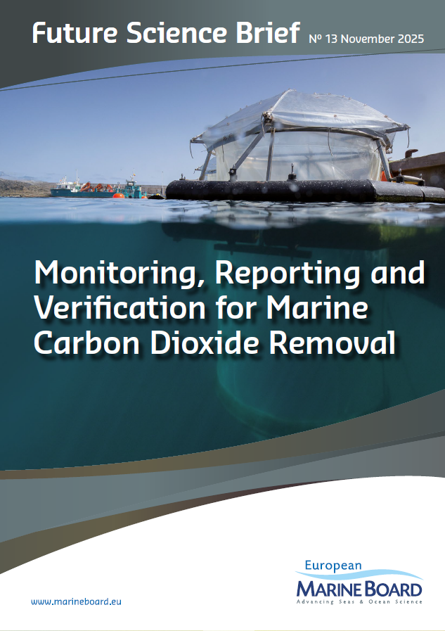
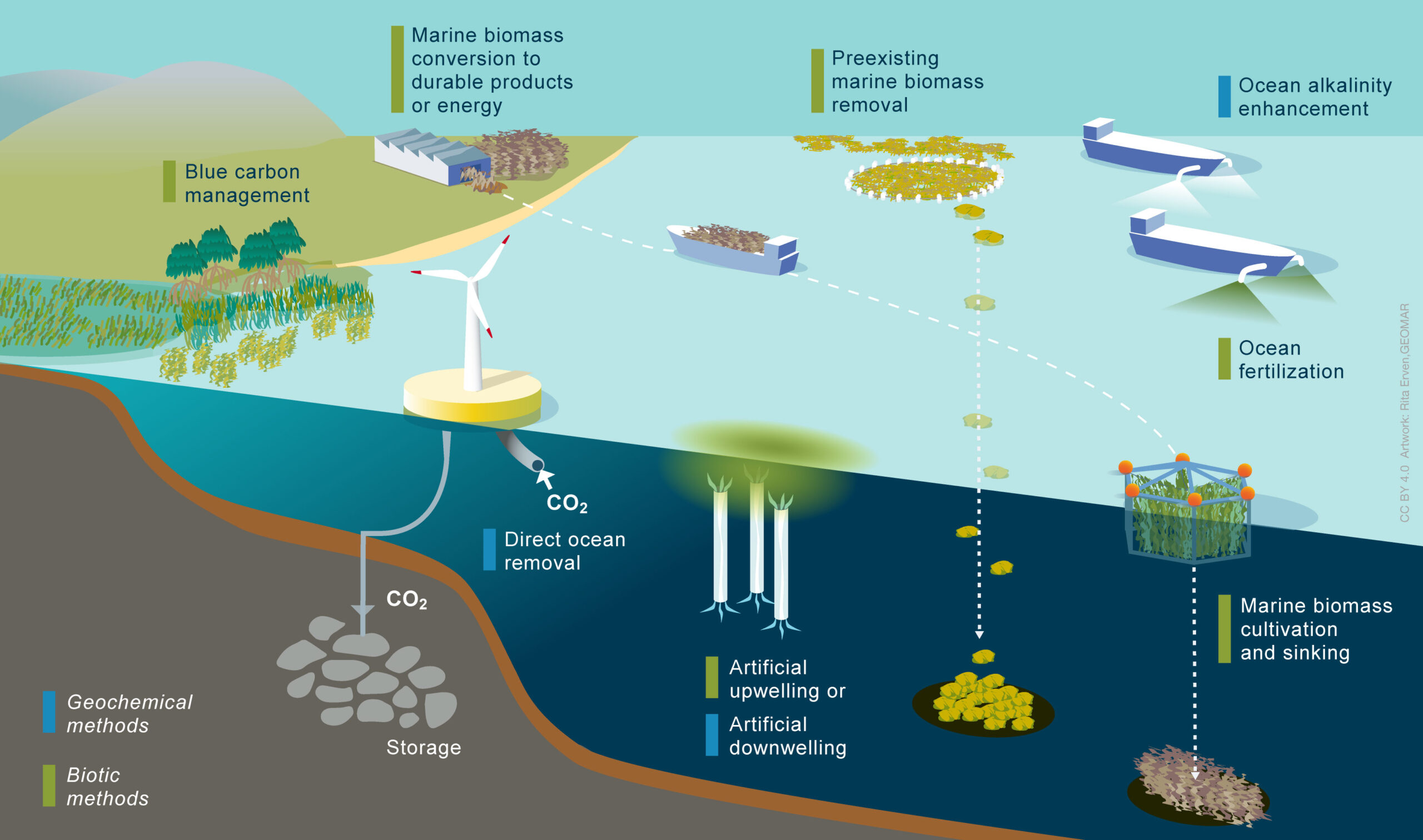
A group of internationally renowned marine scientists under the European Marine Board has published the Future Science Brief on ‘Monitoring, Reporting and Verification for marine Carbon Dioxide Removal’. The report is clear: rapid CO2 emissions reduction is the top priority. Carbon Dioxide Removal is not a substitute for emissions reductions; (marine) CDR can only be considered as a potential supplementary measure to support achievement of net-zero emissions. The report clarifies the current scientific, technical and regulatory challenges that must be addressed to develop appropriate and reliable MRV for any future mCDR activities, to safeguard Ocean health and those who depend on it. According to the State of Carbon Dioxide Removal report, marine CDR methods contribute less than 0.1% to current removal efforts, but this field is growing rapidly. The potential impacts on the marine environment are not yet clear but could be significant.
Carbon Dioxide Removal (CDR) methods, including those focused on marine environments, are currently being researched and piloted. They are seen as a means to address residual emissions and remove legacy carbon from the atmosphere once greenhouse gas emissions have been reduced, and to achieve the Paris Agreement’s climate goals.
Monitoring, reporting and verification (MRV) is a structured process to collect, disclose and independently verify data on mCDR activities. The process includes quantifying CO2 removals, durability, uncertainties and environmental impacts. Going forwards, science-based guidance to develop these robust, transparent and scientific MRV frameworks for mCDR is needed.
The international working group of thirteen researchers has presented its findings and clear recommendations on the Monitoring, Verification and Reporting for mCDR activities. Under the leadership of Dr Helene Muri, Senior Researcher at NILU and Norwegian University of Science and Technology (NTNU), Norway, and Dr Olivier Sulpis at CEREGE – Aix-Marseille University, CNRS, IRD, France, the team produced the report, which was launched on November 17th, 2025, by the EMB in a webinar.
The document emphasises, among other points, research knowledge gaps that present major challenges for the practical implementation and efficiency of mCDR methods in the Ocean. Among them are uncertainties about the processes and impacts, and the duration for which the carbon could be stored in the Ocean.
“No mCDR method currently has a sufficiently robust, comprehensive MRV in place,” says Helene Muri. “This means that efficient and safe deployment of mCDR methods cannot be ensured at the moment”.
Building the foundations for responsible development
The working group emphasises that investing in science and innovation, such as Ocean observations and modelling approaches and infrastructure, can help to advance the MRV field. “If we would like to consider the use of mCDR, we have to invest in knowledge generation for MRV now,” says Helene Muri. “That will enable the development of fit-for-purpose MRV frameworks if or when we reach large-scale mCDR implementation.”
The researchers also call for the development of robust governance to underpin MRV for mCDR. Helene Muri: “We do not currently have dedicated governance frameworks for MRV for mCDR”. There is a need for a comprehensive, regulatory framework for MRV that will overcome the fragmentation, inconsistencies and lack of global governance of existing MRV systems.
Find out more about the Future Science Brief and download it here.
The Belgian Federal State is represented in the EMB by the Belgian Science Policy Office (BELSPO) and in the EMB Communication Panel by the Institute of Natural Sciences.
Elia Asset NV has submitted an application for the modification of the ministerial decree of 26 september 2023 granting Elia Asset NV an authorization for the construction, an operating license, and a Natura 2000 permit for the Modular Offshore Grid 2 in the maritime areas under Belgian jurisdiction.
Construction of the energy island started on April 1, 2024, based on the environmental permit and Natura 2000 authorization granted on September 26, 2023. Elia Asset NV plans to use an alternative landing method for the export cables, with access channels and turning basins in the coastal zone near Blankenberge/Zeebrugge. This technique is not included in the above-mentioned environmental permit and Natura 2000 authorization and is therefore subject to an additional environmental impact assessment procedure.
The application, which also includes the supplementary environmental impact assessment report prepared by the applicant, the draft appropriate assessment, and a non-technical summary, can be consulted at the offices of MUMM (Management Unit of the Mathematical Model of the North Sea) in Brussels (Institute of Natural Sciences, Vautierstraat 29, 1000 Brussels; mdevolder@naturalsciences.be; tel. 02 627 43 52) or in Ostend (3de en 23ste Linieregimentsplein, 8400 Ostend; jhaelters@naturalsciences.be; tel. 02 788 77 22), by appointment only and during office hours between 9:00 a.m. and 5:00 p.m. The file has also been forwarded to the coastal municipalities.
The documents can also be consulted electronically (in Dutch) :
The first agenda item was to approach the tools or systems we have available from a legal perspective.
This included reflection on the so-called shadow fleet, a network of ships or vessels that use cloak-and-dagger tactics to avoid sanctions, circumvent safety or environmental regulations, evade insurance costs, or engage in other illegal activities.
Professor Kristina Siig (Professor of Maritime Law and Law of the Sea, University of Southern Denmark) emphasized the importance of the principle of “innocent passage.” The United Nations Convention on the Law of the Sea (UNCLOS) stipulates that innocent passage of ships through territorial waters must be permitted as long as they do not threaten the peace, order, or security of the coastal state concerned.
Several recent maritime incidents were also analyzed. What legislation applied? And, above all, how can we better anticipate and respond in the future?
Feedback from working groups
On a more operational and technical level, the Summit regularly provides feedback from the chairs of the various expert groups. These groups met in Aalborg, Denmark, in May 2025 and reported on the most important findings, new techniques, and trends.
The approach to recent incidents such as those involving the Solong and the Stena Immaculate, and the MSC Baltic III, were also discussed in more detail.
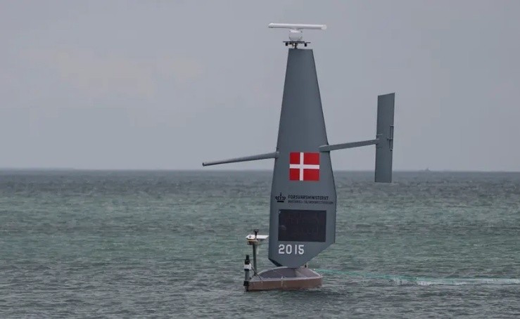
Denmark has several systems that it integrates to obtain the most comprehensive picture possible of activities above its waters. Its long-term vision is supported by systematic training of all coastguard personnel, enabling them to work smoothly with European data systems. Since the launch of this initiative in 2017, more than 600 employees have been trained. Denmark uses, among other things, the RPAS (Remotely Piloted Aircraft System) service of the European Maritime Safety Agency (EMSA) and has developed its own manual for its operational use.
Last year, several saildrones were also tested in Danish waters. Four drones were deployed simultaneously and controlled by a single operator on shore. They proved exceptionally resilient to the unpredictable weather conditions and even withstood a Category 5 hurricane. This project, carried out by a private company, is a prime example of successful collaboration between government and industry, aimed at knowledge building and market exploration.
In addition, all participating Member States collaborated last year on a thematic paper on “Safety and Security in Windmill Parks.” Belgium also has experience in this area and contributed to the project.
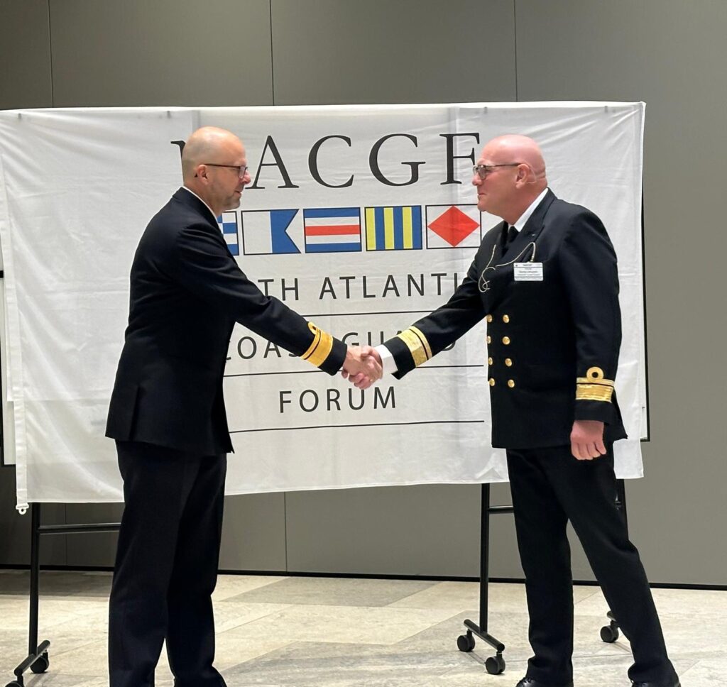
Finally, during the closing session, the presidency of the NACGF was officially handed over to Iceland.
The Scientific Service “Management Unit of the Mathematical Model of the North Sea (MUMM)” of the Institute of Natural Sciences is a partner in the Belgian Coast Guard cooperation and is closely following the developments discussed during the NACGF Summit.
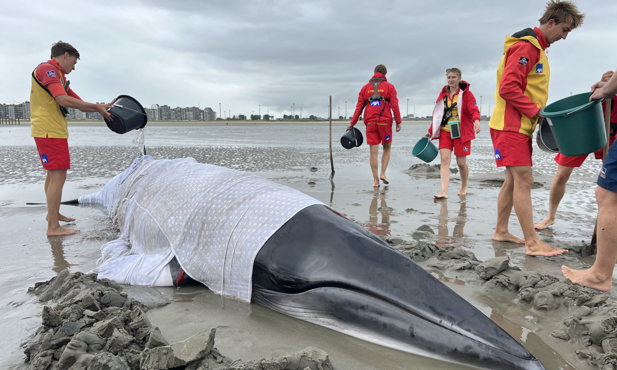
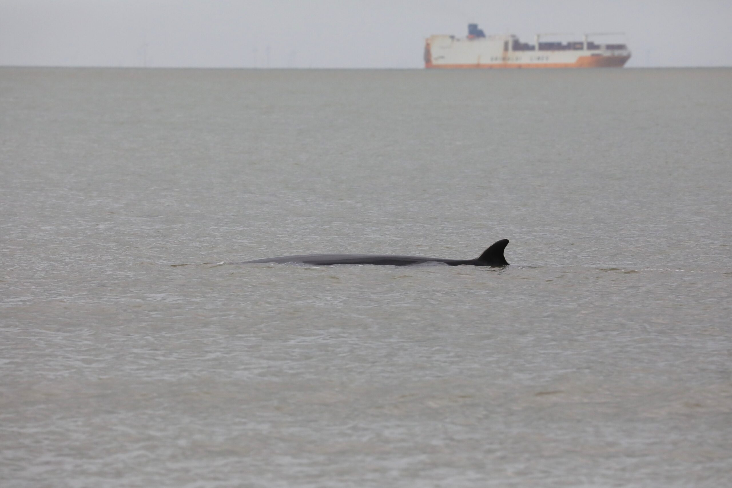
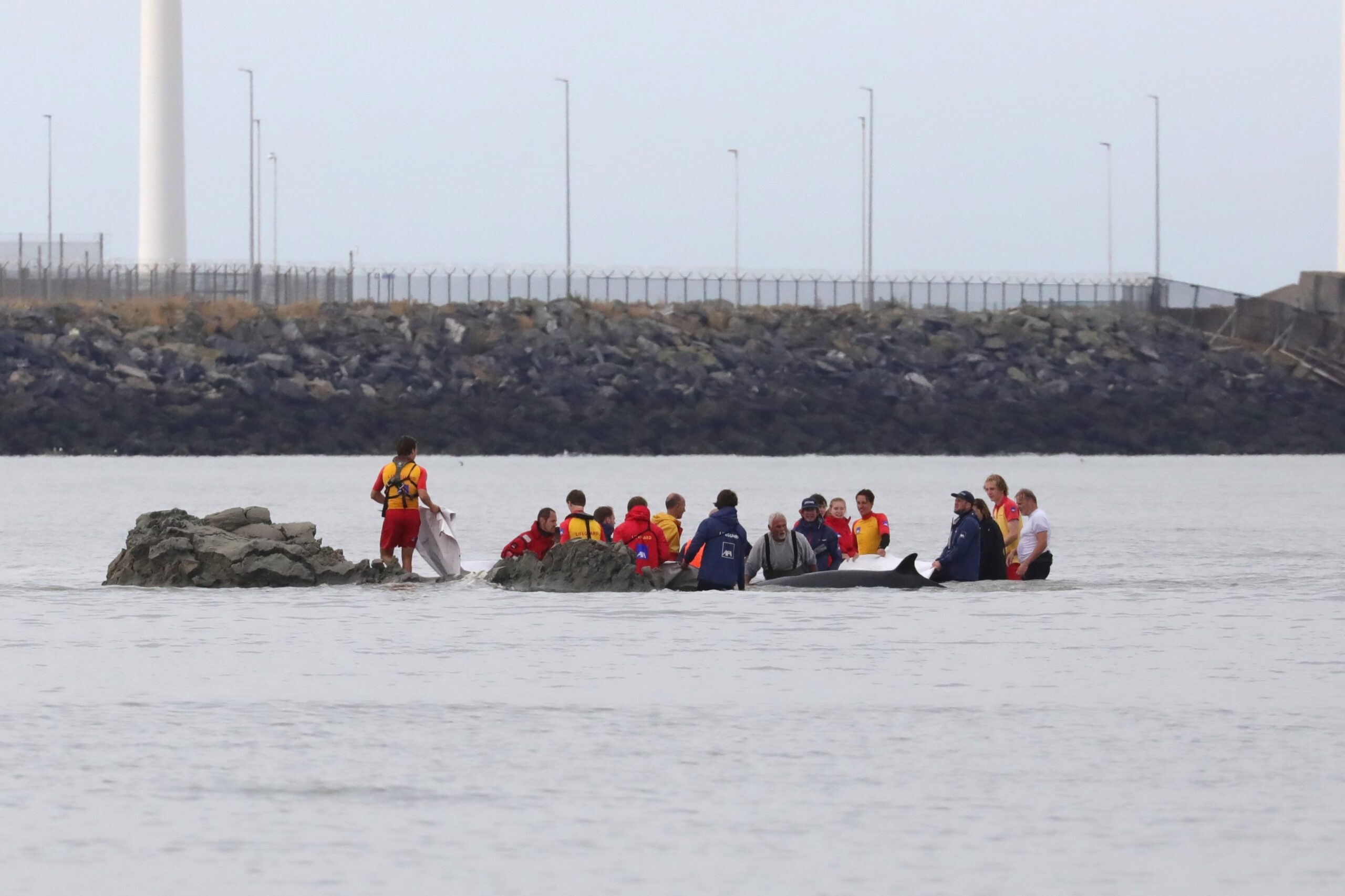
A minke whale, approximately 6 meters long, ran into trouble in the shallows of Heist Bay on August 31st. Lifeguards and emergency services kept the animal wet in a shallow pool for hours, and a quickly dug channel allowed the whale to be guided back to sea as the tide rose. Although the animal returned to shallow water twice more, they succeeded in guiding it deeper each time. However, doubts remained about the chance of survival.
On Sunday, August 31st, a minke whale (Balaenoptera acutorostrata) ran into trouble off the Belgian east coast. Just before noon, the animal ended up in the treacherous shallows of Heist Bay, and as the tide receded, it was completely exposed.
Reducing the pressure of weight
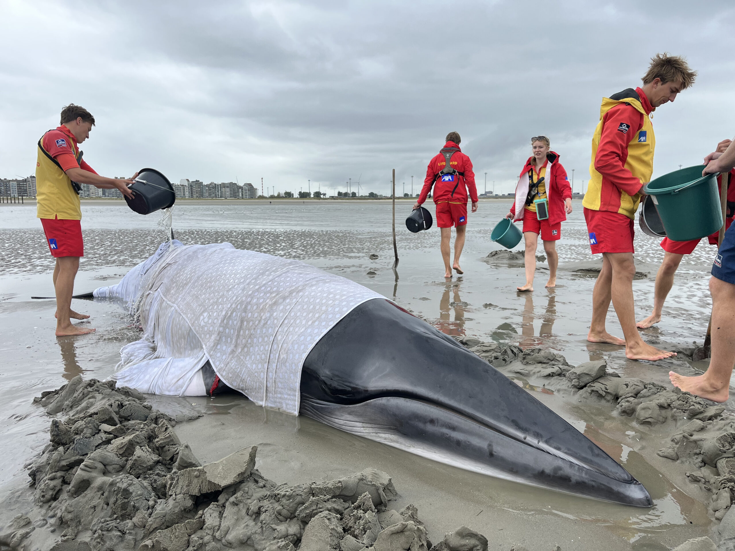
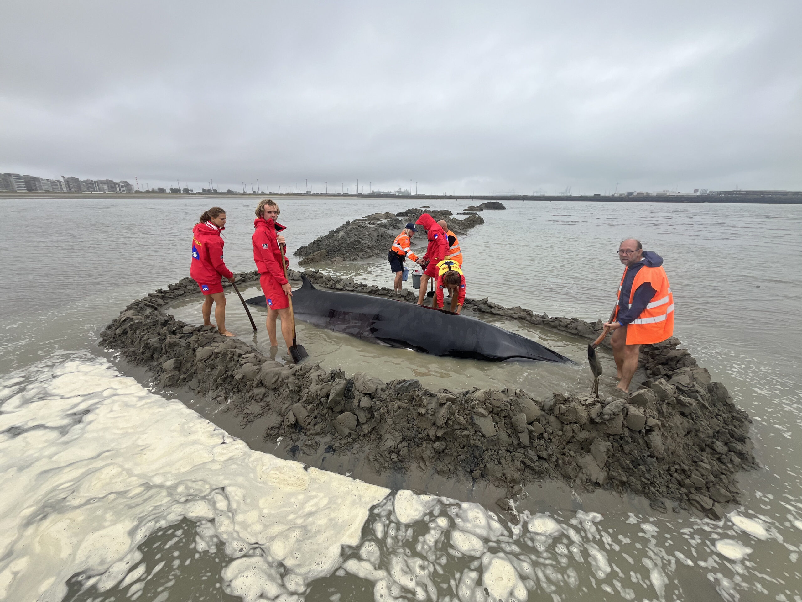
Lifeguards worked all afternoon to rescue the unfortunate minke whale. They built a wall of sand around the animal and kept it wet in a shallow pool. It’s important that a cetacean on dry land is supported as much as possible to reduce the pressure of its own weight on its organs. Even a water depth of just 25 cm is better than simply lying dry.
The minke whale, approximately 6 m long and estimated to weigh 4 tons, remained relatively calm. The animal was very alert, its eyes constantly darting in all directions. Only occasionally did it swat its tail or open its mouth, briefly revealing its perfectly aligned cream-colored baleen. The minke whale otherwise appeared healthy: it seemed well-fed, its skin was perfectly intact, and it carried few parasites.
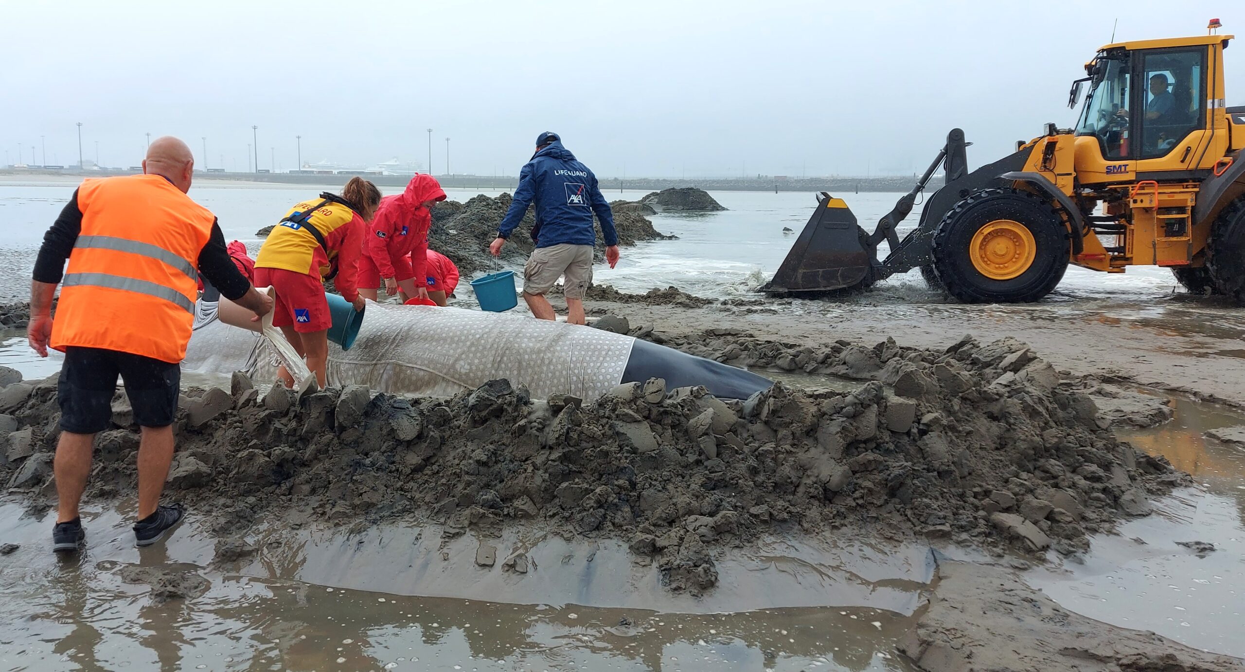
Marine biologists from the Institute of Natural Sciences advised on appropriate actions. A municipal bulldozer was used to dig a small canal: by deepening the shortest route to the sea, the animal could return more quickly with the rising tide.
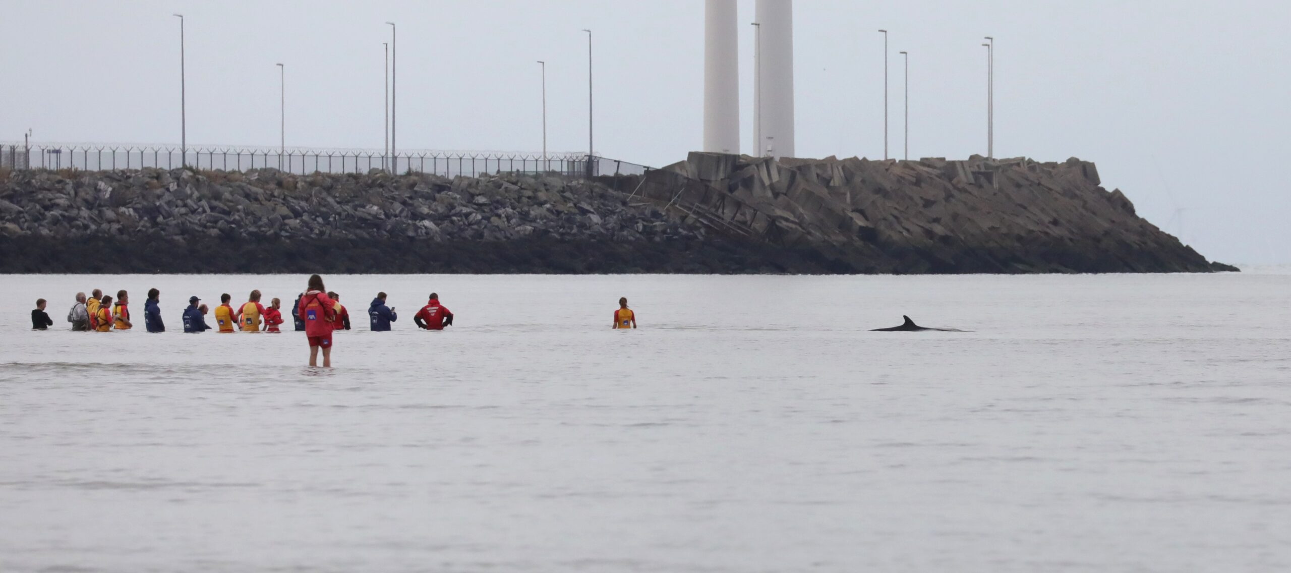
The lifeguards, along with several firefighters, a veterinarian, and a few volunteers, remained in the water for hours, initially knee-deep, but later waist-deep as the tide rose. Finally, around 4 p.m., they were able to guide the animal through the deepened channel to deeper water. After swimming back and forth for about an hour and a half further out to sea, the animal returned to shore twice. Each time, the minke whale became stuck in shallow water, but was quickly pushed back. The animal was last seen in the evening.
Shortly after the last action, the animal disappeared underwater near the coast. The minke whale was not seen again in the last hours before nightfall. This is somewhat strange, as a cetacean that experiences stress during strandings and exerts itself physically in attempts to free itself is expected not to immediately dive deeply, but to remain at the surface to breathe regularly. Moreover, deep diving is not possible in the shallow Bay of Heist.
Prompted by the repeated return of the minke whale to coastal waters, but also mindful of the possibility of a carcass washing ashore, the emergency services and the Institute of Natural Sciences remained vigilant in the hours that followed. On Monday, September 1st, when two more low tides had already occurred and no more minke whale was found—dead or alive, the final alert was called off shortly after noon.
While August 31st was a wonderful end to the summer season for the lifeguards – a team-building exercise they will never forget, and the many others who contributed (including the fire brigade, police, technical service, the veterinarian, and several volunteers) also deserve praise, fears about the future fate of the Belgian minke whale now appear to be well-founded.
On Friday evening, September 5th, a dead minke whale washed ashore in Katwijk, the Netherlands. This animal, too, was approximately 6 meters long and turned out to be a male. The carcass was taken to Utrecht University. Based on a detailed comparison of photographs of the Heist minke whale and the Katwijk carcass, the Dutch and Belgian researchers concluded that the animals at both locations were the same. A scar on the left flank, among other things, was decisive.
This conclusion was reinforced by a reconstruction of the dead minke whale’s trajectory in the days before it washed ashore. This “back-in-time” simulation, based on a scientific model in which currents play a key role, was performed by the Institute of Natural Sciences. The model brought the minke whale remarkably close to the location where it was last seen on August 31st. This result also indicates that the animal likely died shortly after its last sighting off the Belgian coast, as a living whale would not simply be carried along by the currents.
Minke whales remain rare in Belgium. For an overview of the most recent strandings and sightings in Belgium, please refer to the 2024 marine mammal report (available in Dutch and French) and a web article about a young minke whale that washed ashore in Ostend in 2024.

 Monitoring, reporting and verification (MRV) is a structured process to collect, disclose and independently verify data on mCDR activities. The process includes quantifying CO2 removals, durability, uncertainties and environmental impacts. Going forwards, science-based guidance to develop these robust, transparent and scientific MRV frameworks for mCDR is needed.